Ljósufjöll
| Ljósufjöll | ||
|---|---|---|
|
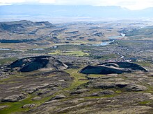
View from Eldborg crater to the mountain range of Ljósufjöll |
||
| height | 1063 m | |
| location | Iceland | |
| Mountains | Ljósufjöll | |
| Coordinates | 64 ° 52 '12 " N , 22 ° 13' 48" W | |
|
|
||
| Type | Central volcano with its own column system | |
| rock | predominantly rhyolite | |
| Last eruption | 1148 (active) | |
|
Berserkjahraun |
||
The Ljósufjöll are a volcanic mountain range in western Iceland . They are located away from the actual rift zone in a so-called flank zone on Snæfellsnes .
One has to distinguish the Ljósufjöll in the narrower sense, the actual mountain range and central volcano , from the Ljósufjöll in the broader sense, the surrounding volcanic system .
The Ljósufjöll mountain range
The mountain range lies in the east of the Snæfellsnes peninsula and is the central volcano of the system.
The name means mountains of light or light mountains in Icelandic and stems from the fact that the six peaks v. a. consist of liparite rock and therefore glow widely, similar to the Móskarðshnjúkar near the Esja or the mountains around Landmannalaugar , such as the Brennisteinsalda . You can see them from Reykjavík on some days .
The actual Ljósufjöll, d. H. the central volcano with the magma chamber are located west of the Hnappadalur and reach a height of 1063 m. This makes them the highest mountains on the Snæfellsnes peninsula after Snæfellsjökull . It is a series of five wedge-shaped peaks in a northwest-southeast orientation, with another peak in front of them to the north.
You can climb the mountains from the south side.
The Ljósufjöll volcanic system
This volcanic system is of considerable size as we know today. It extends from the Berserkjahraun in the north of Snæfellsnes near Stykkishólmur over the actual Ljósufjöll and the entire Hnappadalur to the Grábrók craters adjacent to the Baula , extends over 90 km and is one of the longest in Iceland.
The volcanic system is still considered active, as the last eruption took place around 1000 years ago in the Hnappadalur.
The Hnappadalur
See also: main article Hnappadalur
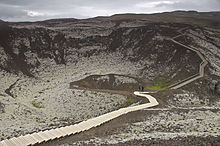
The bowl-shaped Hnappadalur is about 40 km north of Borgarnes on the Snæfellsnes peninsula and at the foot of the central volcano of the Ljósufjöll. There are numerous cinder cones there , including the Eldborg welding cinder cone .
The Grábrókkrater
There are three craters, the main one is called Stóra-Grábrók, the smaller one is called Litla-Grábrók. A third crater called Grábrókarfell is to the west of them. They border directly on the Hringvegur north of Borgarnes in Norðurárdalur . The village and the University of Bifröst are at their feet in the lava field they created.
Numerous hiking trails can be found on and around the craters, including on lovely Hreðavatn .
See also
Web links
Photos and videos
Scientific contributions
- Ljósufjöll in the Global Volcanism Program of the Smithsonian Institution (English)
- S. Flude, R. Burgess, DW McGarvie: Silicic volcanism at Ljósufjöll, Iceland: Insights into evolution and eruptive history from Ar – Ar dating. In: Journal of Volcanology and Geothermal Research. 169, 2008, p. 154, doi : 10.1016 / j.jvolgeores.2007.08.019 . (On the eruption history of the Ljósufjöll, engl.)
- E. Martin, ea: Crustal thermal state and origin of silicic magma in Iceland: the case of Torfajökull, Ljósufjöll and Snæfellsjökull volcanoes. ( Memento April 15, 2010 on the Internet Archive ) Contrib Mineral Petrol (2007) 153: 593-605; doi : 10.1007 / s00410-006-0165-5 (PDF file, English)
Individual evidence
- ^ Ari Trausti Guðmundsson, Pétur Þorleifsson: Íslenk fjöll. Gönguleiðir á 151 tind. Reykjavík (Mál og Menning) 2004, p. 194 f.


