Baula
| Baula | ||
|---|---|---|
|
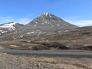
Baula from the driveway to the Brattabrekka pass |
||
| height | 934 m | |
| location | West - Iceland | |
| Coordinates | 64 ° 50 ′ 57 ″ N , 21 ° 26 ′ 17 ″ W | |
|
|
||
| Type | Laccolith | |
| rock | Rhyolite | |
| Age of the rock | Pliocene | |
| First ascent | Halldór Bjarnason (1851) | |
|
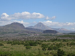
Baula surrounded by from left to right. Hraunsneföxl , Grábrók and Litla-Baula |
||
|
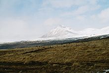
Baula from the south |
||
Baula [ ˈbœyːla ] is a mountain in western Iceland with a height of 934 m . The mountain is located in the north of the municipality of Borgarbyggð .
location
Baula is located near the ring road at the Bifröst boarding school, northwest of the Grábrók crater . Borgarnes is about 50 km southwest . There are numerous weekend houses in the nearby Hreðavatn in particular . The Norðurá River flows by not far away .
In the northeast of the Baula, a somewhat lower rhyolite dome of darker color rises up , the Litla-Baula (840 m). The smaller volcano was active about 3.5 million years ago. Further east is another cone called Skildingsfell . There are deep valley cuts between the mountains.
geology
The mountain with its distinctive shape is not, as one might assume, a stratovolcano or a palagonite cone , but a large intrusion ( laccolith ) of rhyolite rock , which is only visible because the Ice Age glaciers above Borgarfjörður about 1500 m Have sanded off rock.
Baula is characterized by its almost perfect cone shape. The intrusion came from the Reykjadals volcano , a central volcano in Dalir, which has long since been extinct , and is around 3.5 million years old; it thus originated at the end of the Tertiary .
The mountain is made up of a type of liparite or rhyolite . He explains the bright, light color scheme of the mountain. Man held the stone long for unique and called him Baulit or Baulasteinn . The term is no longer used today. The rock is also not unique, but can be found in the vicinity of other central volcanoes throughout the country.
The pointed shape explains itself u. a. because the mountain probably protruded from an ice age glacier for a longer time than Nunatak .
In contrast to the Baula itself, Litla was Baula before cs. An active volcano for 4 million years.
Legends and stories about the Baula
Litla-Baula is a household name for Baula's daughter and Skildingsfell is her grandson.
In the 19th century, locals made a popular joke with strangers by telling them that the top of the Baula was the entrance to a beautiful and rich country with dwarfs who raised fat sheep. It was a kind of Icelandic land of milk and honey story .
Another legend reports that there is a pond on the mountain. There was a wishing stone there that would only float to the surface once a year and would fulfill all wishes of those who could grasp it.
Mountain hiking on the Baula
Baula can, for example, be climbed from the west from the Bjarnadalsá valley. However, the rock is very loose in places and the slopes are steep. So it is a more demanding mountain hike. If the weather permits, you will be rewarded with an exceptionally beautiful view.
As far as is known, Halldór Bjarnason from Litla-Gröf was the first to climb the mountain in 1851.
See also
Web links
Individual evidence
- ↑ a b Freysteinn Sigurðsson: Borgarfjarðarhérað milli Mýra og Hafnarfjalla. (= Ferðafélag Íslands. Árbók. 2003). sl, Reykjavík 2005, ISBN 9979-9499-9-6 , p. 247.
- ↑ http://www.researchgate.net/profile/Agust_Gudmundsson/publication/266386787_Dykes_sills_laccoliths_and_inclined_sheets_in_Iceland/links/542efd600cf277d58e91eclinede.pdf A. Gudmundsson et al., Dykes sills , p. 7 in Icelandic and inc . 2014; sheets . Retrieved November 8, 2015
- ↑ cf. z. B. Ari Trausti Guðmundsson , Pétur Þorleifsson: Íslensk fjöll. Gönguleiðir á 151 tind. Mál og Menning, Reykjavík 2004, ISBN 9979-32493-7 , p. 24 f.
- ↑ cf. z. B. Ari Trausti Guðmundsson, Pétur Þorleifsson: Íslensk fjöll. Gönguleiðir á 151 tind. Mál og Menning, Reykjavík 2004, ISBN 9979-32493-7 , p. 25.
- ↑ cf. z. B. Ari Trausti Guðmundsson, Pétur Þorleifsson: Íslensk fjöll. Gönguleiðir á 151 tind. Mál og Menning, Reykjavík 2004, ISBN 9979-32493-7 , p. 24.
- ↑ cf. also Vegahandbókin. Ed. Landmælingar Íslands. 2006, p. 60


