Norðurá (Hvítá)
| Norðurá | ||
| Data | ||
| location | Iceland | |
| River system | Hvítá (Borgarfjörður) | |
| Drain over | Hvítá → Borgarfjörður → Atlantic | |
| source | on the Holtavörðuheiði plateau | |
| muzzle |
Hvítá coordinates: 64 ° 39 ′ 0 ″ N , 21 ° 39 ′ 0 ″ W 64 ° 39 ′ 0 ″ N , 21 ° 39 ′ 0 ″ W.
|
|
| length | 62 km | |
| Catchment area | 575 km² | |
| Communities | Borgarbyggð (formerly: Bifröst ) | |
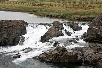
| Waterfalls: Glanni , Laxfoss | ||

Norðurá is a river in west Iceland in the municipality of Borgarbyggð and in the district of Mýrasýsla .
Geographical data
The average amount of water in summer is 10–40 m³ / sec. and in winter 6–30 m³ / sec. The river has a length of 62 km.
course
The river begins in Holtavörðuvatn on the Holtavörðuheiði plateau . From there it flows through the Norðurárdalur and flows into the Hvítá .
Cumulative flow
It is a so-called confluence river, ie a river that absorbs numerous other rivers and can swell strongly in summer after heavy rainfall and in spring when the snow thaws. Therefore the vegetation does not reach down to the water surface. (In contrast, there are source rivers such as the suction or glacier rivers such as the Jökulsá á Fjöllum .)
use
Salmon river
The river is known to be one of the best salmon rivers in the country. You can recognize fishing areas by the fact that there are signs with numbers or place names on a path on the riverbank at irregular intervals.
Hiking opportunities
There are marked hiking trails along the river, e.g. B. to the waterfalls Laxfoss and Glanni just south of Bifröst .
The Norðurártal
The valley of the river Norðurá (isl. Norðurárdalurinn) is the longest valley of the administrative district Mýrasýsla , up in the mountains of the Holtavörðuheiði narrower and then broadly tapering from about the height of the rest area Baula.
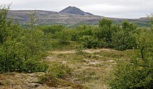
At Bifröst the massif of the old and cooled central volcano Hallamúli with the Grjótháls spreads to the east . On the western bank, however, other volcanic mountains are even more visible, the cone of the Baula and the smaller Litla Baula , witnesses of the active volcanism in the area 4 million years ago, the cliff-like slope of the Hraunsneföxl and the Grábrók crater, the northernmost foothills of the Ljósufjöll volcanic system , a volcanic system that is still active today , the central volcano of which is about 90 km away on Snæfellsnes .
Here, too, there are many hiking opportunities, from alpine mountaineering on the Baula to hikes of medium difficulty such as over the mountains in the west to the lakes Langavatn and Hítarvatn as well as walks around the lake Hreðavatn with its modern tree plantings.
See also
Web links
- Info page of the Association of Icelandic Fishing Associations for Norðurá (English)
- IMO (Isl. Staatl. Wetteramt), Hydrology (latest data on the river in real time) (English)
Individual evidence
- ↑ a b angling.is
- ↑ a b Íslandshandbókin. Náttúra, saga og sérkenni. 2. bindi. Edited by T. Einarsson, H. Magnússon. Örn og Örlygur, Reykjavík 1989, p. 140.
- ↑ Angling.is: Norðurá ; accessed: September 6, 2012.
- ↑ s. Ari T. Guðmundsson, among others: Land im Werden. An outline of the geology of Iceland. Vaka-Helgafell, Reykjavík 1996, p. 24.
- ↑ Angling.is ; accessed: September 6, 2012
- ↑ cf. Freysteinn Sigurðsson: Borgarfjarðarhérað á milli Mýra og Hafnarfjalla. Ferðafélag Íslands, árbók 2004. Reykjavík 2004, 243ff.


