It yes
| It yes | ||
|---|---|---|
|
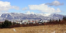
Esja in winter as seen from Reykjavík |
||
| height | 914 m | |
| location | Iceland | |
| Coordinates | 64 ° 14 '24 " N , 21 ° 37' 48" W | |
|
|
||
The Esja [ ˈɛːsja ] is a mountain range in the southwest of Iceland , approx. 10 km north of the capital Reykjavík . It is a mountain range made up of various volcanic products and sediments, the highest point of which reaches a height of 914 m .
Surname
The origin of the name is unclear. In the Kjalnesinga saga , a wealthy widow Esja is mentioned among Irish immigrants, but conversely (aitiologically) the personal name is derived from the place / mountain name.
geography
The elongated mountain range is approx. 20 km long and stretches in the narrower sense from Kollafjörður to Hátindur, but actually to Kjós to Mount Skálafell , where it touches the areas of three extinct central volcanoes, namely the Stardals volcano at Kjós (with the center about under today's mountain Skálafell), the Kollafjörður volcano and the Hvalfjörður volcano .
Some peaks and cuts characterize the mountain range. The easternmost peak is Hátindur (909 m). For a long time it was thought to be the highest peak, but it turned out that the hill north of Gunnlaugsskarð is even higher, namely 914 m.
Particularly noticeable is the mountain Kistufell , which protrudes the most to the south and is roughly at the height of Mosfellsbær .
geology
Esja is located in the western active volcanic zone of Iceland, but is no longer an active volcano itself. On the contrary, the rock at its base is one of the oldest rocks in the vicinity of the capital.
The mountain range Esja formed in the Tertiary . In the warm periods lava flowed out, and in the cold periods emerged subglacial mound under the glacier .
The oldest signs of volcanic activity are in the west (approx. 3.2 million years old) and the youngest in the east of the mountain (approx. 1.8 million years old).
The oldest layers come from eruptions of the Hvalfjörður volcano, the somewhat younger ones from those of the Kollafjörður volcano and the Stardals volcano.
The rock layers of the Esja incline slightly to the southeast. This is explained by the fact that the Stardals central volcano was located there, central volcanoes always weigh more heavily than the layers in their vicinity and thereby cause them to tip over.
The plate tectonics move the rock layers over time to the west from the active volcanic belt away, about one centimeter per year. Intrusions , ie extensive magma channels, starting from the old central volcanoes at Kjalarnes and Stardal, later penetrated the existing rock layers. Thick layers of lava were created and piled on top of each other. The Ice Age glacier then abraded these stacks, leaving the highest intersection points, of which Esja is one. The mountain massif becomes younger towards the top and towards the east, which is explained by the shift away from the active volcanic belt.
The mountain range is criss-crossed by colorful intrusions of gabbro , parts of old magma chambers and formerly active volcanic vents, which can be seen particularly well on its eroded west side near Kjalarnes.
The uppermost layers of the mountain range consist alternately of basalt lava pyroclastics and hyaloclastites and other products of subglacial volcanic eruptions.
Finally, there are also layers of sediment in between.
Moskarðshnúkar and the beauty of the mountain range
The easternmost peaks of the mountain range, the Moskarðshnúkar , shine unusually brightly. A Reykjavík writer, it is said, said he saw the sun rise there after a long period of rain. When he looked more closely, he discovered that it was only the rock that had such luminosity. In reality, it is rhyolite (also called liparite), which is always found in the center of old (and active) central volcanoes, here in the center of the Stardals volcano.
Esja is also known for its aesthetic shape and the richness of color of the rock. The writer Þórbergur Þórðarson wrote a famous poem about the mountain.
Hiking on the Esja
Due to its close proximity to the capital of the country, Esja is a very popular local recreation, hiking and climbing destination.
Numerous paths and via ferratas lead to the various peaks. A parking lot for hikers is located directly at Hringvegur .
The two signposted hiking trails lead to the Þverfellshorn and the Kerhólakambur ( 851 m ), and helicopter flights for tourists are also offered.
See also

Web links
- Iceland Review , walking on the Esja with slideshow link (English)
- Photo: Móskarðshnjúkar
- Sigrún H. Þorgrímsdóttir: Bæjarfjallið Esja. IN: Morgunblaðið November 25, 2000; Accessed: April 21, 2011 (detailed description of hiking options on and around the Esja) (Icelandic)
- Hiking on the Móskarðshnjúkar (PDF, Icelandic; 11 kB)
Individual evidence
- ↑ [1] Guðrún Kvaran: Hvað þýðir nafnið Esja? , Vísindavefurinn Háskóla Íslands; Accessed April 21, 2011 (Icelandic)
- ↑ a b c d e f g h Thor Thordarson, Armann Hoskuldsson: Classic geology in Europe 3. Iceland. Harpenden 2002, p. 50f.
- ↑ a b Íslandshandbókin. Náttúra, saga og sérkenni. 1. bindi. Edited by T. Einarsson, H. Magnússon. Reykjavík (Örn og Örlygur) 1989, p. 75
- ^ A b Thor Thordarson, Armann Hoskuldsson: Classic geology in Europe 3. Iceland. Harpenden 2002, p. 48
- ↑ Íslandshandbókin. Náttúra, saga og sérkenni. 1. bindi. Edited by T. Einarsson, H. Magnússon. Reykjavík (Örn og Örlygur) 1989, p. 75; "Esjan er yndisfögur / útanúr Reykjavík (...)" (free translation into German: "Esja is extremely beautiful, seen from Reykjavík (...)")
- ↑ cf. z. B. Iceland Review , Hiking the Esja with a slide show link ; Accessed: April 21, 2011 (English)
- ^ Ari Trausti Guðmundsson, Pétur Þorleifsson: Íslensk fjöll. Gönguleiðir á 151 tind. Reykjavík (Mál og Menning) 2004, p. 158f.


