Esjufjöll
| Esjufjöll | ||
|---|---|---|
|
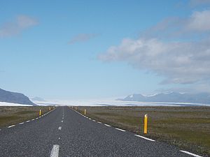
Esjufjöll behind the Breiðamerkurjökull |
||
| height | 1522 m | |
| location | Iceland | |
| Mountains | Esjufjöll | |
| Coordinates | 64 ° 15 ′ 16 ″ N , 16 ° 32 ′ 17 ″ W | |
|
|
||
| Type | Stratovolcano | |
| Last eruption | 1927 (active) | |
|
View from the south of Breiðamerkurjökull and Esjufjöll (right) |
||
The Esjufjöll (pronounced "Ä: sjüfjötl") is a volcanic system in the south of Iceland . It is largely covered by the Vatnajökull glacier cap .
Location and shape
The Esjufjöll lie between the volcanic systems of Öræfajökull and Snæfell and together with them form the Öræfi volcanic belt , a so-called flank zone, which is 40 to 50 km east of the actual rift zone .
Most of the system including a large caldera of 40 km² lies under the Vatnajökull glacier .
Probable eruption in 1927
As far as is known, the volcano only erupted once in historical times, probably in 1927, which, however, resulted in considerable glacier runs . However, a series of earthquakes was also found in October 2002, which could indicate possible magma movements .
Volcanism
The mountain tends to produce alkaline (basaltic) lavas and pyroclastic currents .
Nunataks
Some peaks protrude from the glacier as nunataks , including Esja , the highest mountain in the subglacial massif at 1522 m .
hut
In Esjufjöll there is a hut belonging to the Icelandic Glacier Association Jöklarannsóknarfélag .
See also
Web links
- Esjufjöll in the Global Volcanism Program of the Smithsonian Institution (English)
- Fredrik Holm, ea: Petrology and geochemistry of the Esjufjöll central volcano, Iceland , Nordic Volcanologic Institute, University of Iceland, Report 0303, Summer School 2003, p. 18. (PDF file, abstract, English; 2.4 MB)
- Ski touring, English
Individual evidence
- ↑ a b Esjufjöll in the Global Volcanism Program of the Smithsonian Institution (English), accessed September 20, 2010.
- ↑ T. Einarsson, H. Magnússon (Eds.): Íslandshandbókin. Náttúra, saga og sérkenni. 2. bindi. 1989, p. 936.


