
Landmannalaugar
Landmannalaugar [ ˈlantmanˑaˌløyˑɣar ] is an area near the Hekla volcano in southwest Iceland . It is located in the municipality of Rangárþing ytra , 180 km east of Reykjavík .
Surname
The name, German for the warm springs of the people of the country (sveit) , is explained on the one hand from the hot and cold springs on site, on the other hand from the fact that it is the high pastures of the people from the Landssveit district (namely Landmannaafréttur ).
Volcanism
The protected area is considered to be one of the most beautiful on the island, thanks to the numerous volcanic phenomena and the very colorful mountains.
These are effects of the vicinity of an active central volcano, the Torfajökull . Gray-blue Pechstein is the volcano Bláhnjúkur . Reddish-brown slopes ( rhyolite rock or quartz trachyte ) can be found on the Brennisteinsalda volcano , which in parts also show gray, bluish and white colors due to sulfur and lime precipitation . Green moss and white remains of snow, which are present even in midsummer, add additional color accents. A black, shiny obsidian lava field , the Laugahraun , extends from the solfataras on the Brennisteinsalda to the river, where a hut of the Icelandic Trekking Association stands and where you can bathe in a steaming stream.
Hiking opportunities
In the vicinity of Landmannalaugar lies the delightful Frostastaðavatn lake , up to which one can hike on marked trails. Other paths lead from there to Landmannahellir or the Ljótipollur crater . The Laugavegur trekking path is famous and leads from here via Þórsmörk to Skógar on the coast. Further hikes lead on partly steep, marked and exposed paths to the panoramic mountain Bláhnjúkur .
A marked, relatively easy to walk circular route leads along its foot through the Grænagil gorge , to the Laugahraun lava field and past the fumaroles and mud pots at the Brennisteinsalda volcano over the Laugavegur back to Landmannalaugar. A more demanding circular hike leads from the hut in Landmannalaugar, over the Litla Brandsgil gorge , the Skalli mountain and past the Brennisteinsalda back to Landmannalaugar.
photos


View from the Brennisteinsalda

Landmannalaugar
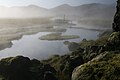
Hot spring in Landmannalaugar in the morning mist

View over the Laugahraun lava field to the Brennisteinsalda volcano
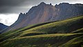
Suðurbarmur near Landmannalaugar, from the direction of Frostastaðavatn

Part of the Laugavegur or the circular route around the Laugahraun lava field (right in the picture), in front the pinnacles of the Suðurbarmur


.jpg)
See also
Web links
.jpg)
Photos and videos
- Photos of a trekking tour
- Panorama: View from Bláhnúkur over Landmannalaugar, on Brennisteinsalda u. a.
Tours
- Tour description, map view and track download from Laugavegur and Fimmvörðuháls
- Mountain tour from Landmannalaugar to the Bláhnúkur
Individual evidence
- ↑ cf. z. BHU Schmid: Dictionary Icelandic-German . Hamburg (Buske) 2001, p. 139.
- ↑ cf. Íslandshandbókin. 2. bindi. 1989, p. 945 f.
- ↑ Chr. Handl, G. Schießl: Iceland. Rother hiking guide. Munich, 1997, p. 36 f.
Coordinates: 63 ° 59 ′ 19 ″ N , 19 ° 3 ′ 50 ″ W.