
Þórsmörk
Coordinates: 63 ° 41 ′ 2 " N , 19 ° 29 ′ 2" W.

.jpg)
The rugged and wooded ridge Þórsmörk (also Thorsmörk , isl. Forest of Thor , [ ˈθour̥sˌmœr̥k ]) is located between the glaciers Tindfjallajökull and Eyjafjallajökull in the south of Iceland , in the municipality of Rangárþing eystra .
location
It lies between the Krossá , Þröngá and Markarfljót rivers . The natural, widely branched glacial river Krossá has dug a bed between the two mountain ranges. In the protected valley of the Krossá and on the surrounding slopes there is a green vegetation of mosses, ferns and light birch forest .
The valley is enclosed on three sides by glaciers, as Mýrdalsjökull rises into the sky at the upper end of the valley in the southeast . On the one hand, this harbors the risk of glacier runs , but on the other hand - similar to Skaftafell - it requires a pleasant microclimate with more sunny days than in the rest of southern Iceland.
Surname

The area is named after the Germanic god Thor / Donar (Isl. Þór ). Typically for Iceland, the field name does not apply to the entire valley, but to the mountain range that borders it to the north, while the valley side south of the mountain river is called Goðaland (Land of the Goden, Land of the Gods). Out of ignorance, however, Þórsmörk is usually used as a nickname for the entire valley.
history
The former settlement of Þórsmörk originally consisted of three farms, all of which no longer exist. Since erosion is a problem, an area particularly threatened by erosion was excluded from grazing and placed under nature protection. Agriculture in the area has traditionally been difficult, today tourism provides an additional source of income.
traffic
Þórsmörk can be reached from Hvolsvöllur via the ring road (no. 1). Road No. 249 branches off directly at the bridge over the Markarfljót stream , which is maintained as a partially unpaved road as far as the hamlet of Stóra Mörk. Then it continues as a gravel road into the valley for a good 20 km. There are, however, some fords that are not entirely harmless, especially in the rear part of the valley . The slope at Gígjökull glacier is impassable due to the volcanic eruption in 2010 due to silted up volcanic ash.
During the main travel season in summer and mostly also at Easter, bus tours to Þórsmörk are offered from the bus station in Reykjavík .
The hiking trail from Skógar to Landmannalaugar also crosses Þórsmörk.
tourism
Þórsmörk offers accommodation, three campsites and a shop. The valley is popular not only with tourists , but also with local young people, who until a few years ago met in their hundreds on the first weekend in July to celebrate the summer.
The area is one of the most rewarding destinations for hikers in Iceland. There are many tours available from there, from mountain and glacier tours to trekking trails such as the famous Laugavegur to short hikes such as the Stakkholtsgjá gorge with its waterfall.
Impressions
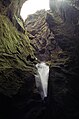
Stakkholtsgjá

Þórsmörk

Þórsmörk in June 2010
after the eruption of
Eyjafjallajökull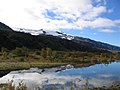
Grove near Þórsmörk


See also
literature
- Karl A. Jørgensen: The Thorsmörk ignimbrite: An unusual comenditic pyroclastic flow in southern Iceland , in: Journal of Volcanology and Geothermal Research, Vol. 1, issue 1, 1980, pp. 7–22 ( Science direct, abstract, English )