Rangárþing eystra
| Basic data | |
|---|---|
| State : |
|
| Region: | Southurland |
| Constituency : | Suðurkjördæmi |
| Sýsla : | Rangárvallasýsla |
| Population: | 1924 (January 1, 2019) |
| Surface: | 1841 km² |
| Population density: | 1.05 inhabitants / km² |
| Post Code: | 860, 861 |
| politics | |
| Community number | 8613 |
| Mayor: | Unnur Brá Konráðsdóttir |
| Contact | |
| Website: | www.hvolsvollur.is |
| map | |

Coordinates: 63 ° 45 ′ N , 20 ° 14 ′ W |
|
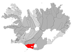
Rangárþing eystra is an Icelandic municipality in the South Urland region . On January 1, 2019, the community had 1924 inhabitants.
geography
The municipality borders the Mýrdalsjökull in the east . In the municipality are the Eyjafjallajökull and the smaller Tindfjallajökull . The municipality is located north of the Vestmannaeyjar .
history
It was formed on March 16, 2002 from the previous rural communities Austur-Eyjafjallahreppur, Vestur-Eyjafjallahreppur, Austur-Landeyjahreppur, Vestur-Landeyjahreppur, Fljótshlíðarhreppur and Hvolhreppur.
places
The largest towns in the municipality are Hvolsvöllur and Skógar .
traffic
The community can be reached via the Hringvegur . The municipality is connected to the Vestmannaeyjar via the Landeyjahöfn harbor . The Laugavegur trekking trail leads from Landmannalaugar into the municipality.
