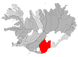
Skaftárhreppur
| Basic data | |
|---|---|
| State : |
|
| Region: | Southurland |
| Constituency : | Suðurkjördæmi |
| Sýsla : | Vestur-Skaftafellssýsla |
| Population: | 583 (January 1, 2019) |
| Surface: | 6946 km² |
| Population density: | 0.08 inhabitants / km² |
| Post Code: | 880 |
| politics | |
| Community number | 8509 |
| Contact | |
| Website: | www.klaustur.is |
| map | |

Coordinates: 63 ° 47 ′ N , 18 ° 3 ′ W |
|
Skaftárhreppur is an Icelandic municipality in the South Urland region . On January 1, 2019, the community had 583 inhabitants.
geography
The municipality borders in the west on the municipality Mýrdalur and Mýrdalsjökull , in the north on the municipalities Rangárþing ytra and Ásahreppur and Vatnajökull and in the east on the municipality Hornafjörður . The eponymous river Skaftá flows through the municipality, which rises from Vatnajökull and is fed by a branch of Langisjór . The Eldgjá Gorge and the Laki Crater are also located in the municipality.
history
The municipality was formed on June 10, 1990 from the municipalities Álftavershreppur , Leiðvallarhreppur , Skaftártunguhreppur , Kirkjubæjarhreppur and Hörgslandshreppur .
places
The largest town in the municipality is Kirkjubæjarklaustur with around 130 inhabitants.
traffic
The municipality can be reached from Vík í Mýrdal in the west or Skaftafell in the east via the Hringvegur ring road.
