Hornafjordur

|
|
| Basic data | |
|---|---|
| State : |
|
| Region: | Austurland |
| Constituency : | Suðurkjördæmi |
| Sýsla : | Austur-Skaftafellssýsla |
| Population: | 2389 (January 1, 2019) |
| Surface: | 6280 km² |
| Population density: | 0.38 inhabitants / km² |
| Post Code: | 780 |
| politics | |
| Community number | 7708 |
| Contact | |
| Address of the municipal administration: | Hafnarbraut 27 780 Höfn Hornafirði |
| Website: | www.hornafjordur.is |
| map | |

Coordinates: 64 ° 15 ′ N , 15 ° 12 ′ W |
|
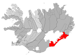
The municipality Hornafjörður ( isl. Sveitarfélagið Hornafjörður ) is located in the southeast of Iceland in the Austurland region .
On January 1, 2019, the community had 2389 inhabitants. The largest and only town in the municipality is Höfn with 1710 inhabitants; 95 inhabitants lived in Nesjahverfi.
Origin of the community
The municipality was created on June 6, 1998 by the merger of the following four municipalities:
- Hornafjarðarbær, formed in 1994 by the merger of the municipality Höfn í Hornafirði with the rural communities Mýrar ( Mýrahreppur ) and Nes ( Nesjahreppur )
- Rural municipality of Bær ( Bæjarhreppur )
- Borgarhöfn ( Borgarhafnarhreppur )
- Rural community of Hof ( Hofshreppur ).
geography
The municipality is located southeast of Vatnajökull . The main town of Höfn is located on a headland between the fjords of Hornafjörður and Skarðsfjörður .
In the western part of the municipality is Morsárfoss, the highest waterfall in Iceland . Parts of the Vatnajökull National Park are on the municipal area. The Kristínartindar and the Svartifoss are nearby . In the southwest lies the large sand area of the Skeiðará river , the Skeiðarársandur , to the north of it the Skeiðarárjökull . Further to the east is the Öræfajökull with the peak Hvannadalshnúkur , which is the highest point in Iceland at 2110 m.
Further east are the Breiðárlón and Jökulsárlón , a large glacial lake and the deepest lake in Iceland.
Transport and infrastructure
In addition to Þorlákshöfn in the town of Höfn, which is located further to the west, the community has the only port on the mainly agricultural south coast, which is flat for shipping.
The municipality is connected to the ring road ( Hringvegur ), the country's main road.
The distance to Reykjavík is 459 kilometers, to Egilsstaðir further north it is 247 kilometers.
Hornafjarðarflugvöllur Airport (English Hornafjörður Airport ; IATA: HFN, ICAO: BIHN) is located around 7 km north of the city of Höfn.
Sons and daughters of the church
- Þórbergur Þórðarson (* 1888 or 1889 in Hali í Suðursveit, † 1974), writer
Town twinning
-
 Kungälv , Sweden
 -
 Risør , Norway
 -
 Samsø , Denmark
 -
 Taivassalo , Finland
See also
Web links
Individual evidence
- ↑ Website of the municipality on the town twinning ( memento of the original from March 6, 2016 in the Internet Archive ) Info: The archive link was inserted automatically and has not yet been checked. Please check the original and archive link according to the instructions and then remove this notice. (Icelandic); Accessed August 13, 2011
