Samsø
| Samsø | |
|---|---|
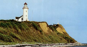
| Vesborg Fyr lighthouse above the cliff | |
| Waters | Kattegat |
| Geographical location | 55 ° 50 ′ N , 10 ° 36 ′ E |
| length | 27 km |
| width | 7.6 km |
| surface | 112.06 km² |
| Highest elevation | Ballebjerg 64 m |
| Residents | 3657 (January 1, 2020) 33 inhabitants / km² |
| main place | Tranebjerg |
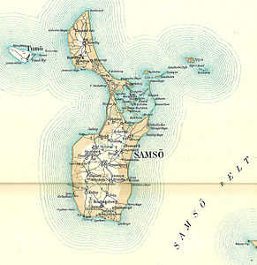
| Map of Samsø and Tunø (1900) | |
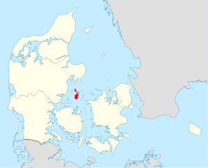
Samsø is a Danish island in the Kattegat , between the Jutian east coast, the Zeeland peninsula of Røsnæs and Fyn . The island has 3657 inhabitants (January 1, 2020) and is 112.06 km² in size. Samsø has been a separate municipality since 1962 and has been part of the Midtjylland region since 2007 .
Samsø recorded the most hours of sunshine in Denmark in 2014 , beating the traditionally sunniest island of Bornholm .
There are ferry connections from Hov (Jutland) to Sælvig and from Kalundborg (Zealand) to Ballen.
Island parts
north
The island is very indented. The northern part was originally an island of its own. The Nordby Bakker are like the sand hills and erosion valleys on the neighboring Mols peninsula, terminal moraines of the Pomeranian phase . The highest point is the Ballebjerg at 64 meters. The Langdal glacial valley runs through the area.
As a result of the post-glacial land uplift, the fairway between the North and South Island silted up. The seafaring Vikings exposed it again by digging the Kanhave Canal .
The main town is Nordby, founded in the Middle Ages (213 inhabitants); some houses from the 18th century have been preserved.
Stavns Fjord
In the Stavns Fjord, which is roughly in the middle of the island, there is a small archipelago . The whole area is a bird sanctuary and game reserve with an interesting fauna and flora in the brackish and salt water zones. Islets and sandbanks offer areas of retreat undisturbed by humans. Here you can also find salt-loving plants such as the vitamin C-rich spoonwort and the salt aster .
In the north of the Stavnsfjord is the small port of Langør. The Stavns Fjord is shielded from the Samsø Belt in the east by a five-kilometer-long headland Besser Rev with the northern tip Havnehage .
The following islets are located in the Stavns Fjord:
- Middle: Hjortholm, Karlskold, Mejlesholm, Yderste Holm and Kolderne
- North-west: Sværm, Ægholm and Hundsholm
- South: Eskeholm, Brokold and Barnekold; all three are connected to Samsø by a mudflat path at low tide (30 cm tidal range ) .
Upstream of the Stavns Fjord are in the Samsø Belt:
- Kyholm, Lindholm Rumpen
- Vejrø and Bosserne
south
The south of Samsø is mainly used for agriculture. The number of organic farmers is increasing.
In Onsbjerg, the first small farmers' association was founded in 1888 to improve the economic situation of farmers. Tranebjerg Church was both a control room and a fortified church.
The lighthouse Vesborg on the southwest coast marks approximately the geographic center of Denmark. It is open to visitors and offers a panoramic view of the neighboring coasts of Jutland, Funen and Zealand.
The largest place is Tranebjerg (814 inhabitants). The highest point of the southern part of the island is Dyret at 51 meters.
tourism
The South Island has a number of prehistoric monuments:
- North of Lushagen is the Knøsen dolmen
- the Janeshøj is for backfilled passage grave
- The Ilsemade kilde is on the beach
- the Rævebakkerne (Fox Mounds) are six burial mounds near Sælvig. Rævebakken is also the name of a double passage grave (Danish: Dobbelt or Tvillingejættestuer )
- the stone box of Better , is now set up outside the museum
- the passage grave of Ørby , is north of the village.
- the Tyvhøj or Kongehøjen lies at Tranebjerg
- Nils Halses Høj is an ancient dolmen on Sælvig Bay.
- Stenstuen is one of the better preserved dolmens.
Samsø is a popular holiday destination, for example due to the ten kilometer long sandy beach in the shallow Sælvigbugt. The narrow connecting roads between the small towns are attractive for cyclists and hikers. There is an old post mill in Brundby.
There are ports of interest for yachtsmen in Langør, Mårup and Ballen.
history
Samsø was settled in the Stone Age. Due to its central location in the Baltic Sea , the island was used as a meeting place in the Viking Age . The name of the island comes from this time. The verb "samle" means to gather and "Ø" means island. The island developed into a strategic place. The Vikings dug a shallow canal around 726 at the narrowest part of the island, the Kanhave Canal . It was originally 500 meters long and eleven meters wide and made it possible to move ships and fleets.
Samsø later became the crown property of various Danish kings. Even in later wars, Samsø did not lose its strategic importance. In the Stavns Fjord, at the end of Besser Rev, you can still find the remains of defensive ramparts.
Around 1675 the island was acquired by Magdalena Gersdorff for her lover, Chancellor Peder Schumacher Griffenfeld . A short time later he was sentenced to death by King Christian V and then to life imprisonment. Sophie Amalie Moth , the 15-year-old daughter of his bourgeois personal physician and lover of the king, then received the island as a gift, and Sophie Amalie became "Countess of Samsø". Landgravine Charlotte Amalie von Hessen-Kassel, the king's wife, tolerated his mistress.
On April 1, 1962, the island became a separate municipality in the Holbæk Office , which was transferred to the Århus Office on April 1, 1970 as part of the local government reform . Today the municipality belongs to the Midtjylland region . It is the third smallest municipality in Denmark after Læsø and Fanø . These three - all of them island municipalities as well as the next largest municipalities Ærø and Langeland - are the only Danish municipalities with fewer than 5,000 inhabitants.
Parish division until 2014
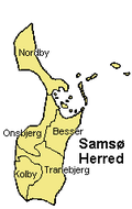
Until 1962 the five parishes ( Danish : Sogn ) on Samsø formed their own harde ( Samsø Herred ). On May 1, 2014, the island's five parishes were merged. The new Samsø Sogn belongs to the Århus diocese . The amalgamation of the Sogne only relates to ecclesiastical issues. In its capacity as Matrikelsogne , i.e. as land register districts of the cadastral authority Geodatastyrelsen , such changes have not had any effect since the abolition of the Harden structure in 1970.
| Parish | Population as of April 1, 2014 |
map | Locality | Population as of January 1, 2020 |
|---|---|---|---|---|
| Nordby Sogn | 430 |  |
Nordby | 213 |
| Onsbjerg Sogn | 664 | Onsbjerg | 229 | |
| Better Sogn | 499 | |||
| Tranebjerg Sogn | 1,674 |
Tranebjerg Brundby (a) |
814 200 |
|
| Kolby Sogn | 479 |
Locations with more than 200 inhabitants are also listed; with entry 0 the actual number is between 0 and 199.
economy
The island advertises its ecological awareness. The island is largely energy-independent thanks to wind power plants (including an offshore wind park consisting of ten 2.3 MW plants from Siemens Windenergie ), a solar power plant and biogas plants and already exports 40% of its energy generation. One example of this energy island project is the involvement of the local population: "In a project like this, as many people as possible have to become owners (...) Then they get a really positive attitude towards it."
traffic
The island can be reached by ferry from Jutland or Zealand . The connection with Jutland is with the ferry Prinsesse Isabella between Sælvig and Hov, to Zealand there is a ferry between Ballen and Kalundborg .
Samsø has an airfield with a 695 m long runway (grass). ⊙
See also
literature
- Thomas Wrede & Ronald Berg: Samsø. Weidle, Bonn 1996, ISBN 3-931135-24-1 .
- Thomas Nykrog: Doors går til Samsø . Politiken, Copenhagen 2002, ISBN 87-567-6675-0 .
- Gudrun Krüger: Tourism in the Kattegat area - Analyzing the travel behavior of Samsø tourists toenhance the tourism potential of the island. VDM, Saarbrücken 2009, ISBN 3-639-14849-5 .
- Karsten Kjer Michaelsen: Politics bog om Danmarks oldtid . Copenhagen 2002 ISBN 87-567-6458-8 pp. 113–114 (description Kongehøjen)
Individual evidence
- ↑ a b statistics banks -> Befolkning og valg -> BEF4: Folketal pr. January 1st demands på øer (Danish)
- ↑ Danmarks Statistics : Statistical Yearbook 2009 - Geography and climate, Table 3 Area and population. Regions and inhabited islands (English; PDF; 39 kB)
- ↑ Annual overview 2014 (Danish), PDF Danmarks Meteorologiske Institut, accessed on January 16, 2015
- ↑ Bornholm Day: Danmarks solskinsø er Samsø Ekstrabladet, September 21, 2014, accessed on January 16, 2015
- ↑ SamsøFærgen January 2015.
- ↑ Statistics banks -> Befolkning og valg -> KM1: Befolkningen January 1st, April 1st, July 1st and October 1st, so and folkekirkemedlemsskab (Danish)
- ↑ Statistics banks -> Befolkning og valg -> BY1: Folketal January 1st efter byområde, alder og køn (Danish)
- ↑ Clemens Höges: Energy: Bigger than Schwarzenegger . In: Spiegel Online . October 19, 2009
- ↑ Elizabeth Kolbert : The Island in the Wind. A Danish community's victory over carbon emissions. In: The New Yorker . July 7, 2008
- ↑ Sebastian Balzer: The miracle of Samsø. In: Frankfurter Allgemeine Zeitung . June 26, 2009, p. 12 ( PDF; 767 kB )
Web links
- Samsø Kommune Official Website
- Visit Samsø Tourist Office
- Description Kongehøjen dän.


