Mols Bjerge National Park
| Mols Bjerge National Park | ||
|---|---|---|
| View of the Kaloe from Mols Bjerge | ||
|
|
||
| Location: | Denmark | |
| Surface: | 180 km² | |
| Founding: | 2007 | |
| Trehoje | ||
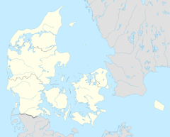
The Mols Bjerge National Park is a protected area in the east of the Jutland Djursland peninsula in Denmark . The national park is 180 km² and includes large areas of forest, heather and grassland as well as lakes and coastal areas. The hills of Mols Bjerge gave the area its name. The highest point is Agri Bavnehøj with a height of 137 meters.
nature and landscape
The landscape was formed by the last ice age, whose sand and stone materials left behind form the present-day hills. Today you can find a varied landscape here, which provides a livelihood for many plants and animals. This is especially true for species that need light and warmth that live on the dry, sandy, sunny slopes. These are plants such as the pasque flower , pink rose and straw flower . Butterflies and many other insects as well as cold-blooded animals such as lizards and adders can also be found here.
history
Burial mounds document the early settlement of the area. As early as the Stone Age, the forest here was cleared. Due to fire management , the continued logging and grazing of the area, there were only three smaller forests around 1688, while the rest were used as pastures, partly as fields or as heather areas.
Web links
- Information about the national park on the homepage of Visit Danmark, German
- National park site, German
- National park map, pdf
Individual evidence
- ↑ a b Information brochure about the National Park, pdf, German ( page no longer available , search in web archives ) Info: The link was automatically marked as defective. Please check the link according to the instructions and then remove this notice.


