Læsø
| Læsø Vor Frue Land |
|
|---|---|
| Marsh-like landscape on Læsø | |
| Waters | Kattegat |
| Geographical location | 57 ° 14 ' N , 11 ° 2' E |
| length | 21.4 km |
| width | 12 km |
| surface | 101.22 km² |
| Highest elevation | Højsande 24 m |
| Residents | 1786 (January 1, 2020) 18 inhabitants / km² |
| main place | Byrum |
| Harde Læsø parishes in 1921 | |
Læsø (also Laesoe or Vor Frue Land ) is a Danish island in the northern Kattegat . As a whole municipality it has 1786 inhabitants (January 1st, 2020). The approximately 101 km² large island (in 1916 it was 116.4 km²) is the most sparsely populated municipality in Denmark. Originally Læsø formed its own harde in Hjørring Amt , consisting of the parishes Byrum Sogn (43.89 km², main town Byrum , 435 inhabitants), Hals Sogn (24.55 km², main town Østerby Havn , 271 inhabitants) and Vesterø Sogn (48, 06 km², main town Vesterø Havn , 371 inhabitants). (Population: January 1st, 2020) From 1970 the island formed its own municipality in the Nordjyllands Amt , which remained untouched in the course of the municipal reform on January 1st 2007 and is now Denmark's smallest municipality Region Nordjylland belongs.
etymology
The name Læsø comes from the legendary giant Aegir , also called Lær or Hlér. He is the god of the sea in Norse mythology . The Danish word ø means "island" in German, so Læsø is the "island of Aegir".
Geography, geomorphology and geology
After the Ice Age inland ice melted about 12,000 to 10,000 years ago, Northern Europe was freed from ice pressure and the region has since experienced a postglacial uplift . At first, however , the postglacial sea level rise occurred faster than the land uplift and Læsø was largely inundated by the sea. The inland ice that covered Læsø in the Pleistocene , left boulders there. A particularly large example with 4 × 3 × 2 meters is the "Topstenen ved Kringelrøn" in the south of the island.
With the slowing of the postglacial sea level rise and the ongoing land elevation, Læsø finally penetrated sea level in the Neolithic, about 4000 years ago. Pottery shards and arrowheads show the presence of people who were probably crossed from southern Sweden or Jutland.
Today the island rises at 6 mm per year, about three times as fast as the Alps. In addition, it grows through the landing of sediment, and old (fossil) beach ridges made of stones and blocks are visible in many places on the island. The skeleton of a stranded sperm whale found in 1872 near Byrum , roughly in the middle of the island's main town , which was dated using the radiocarbon method, proves that the south coast of the island ran far inland around 3,000 years ago.
The Læsø stone in Nordmarken is probably the oldest elevation (“Her fœdtes Læsø af havet” - “Here Læsø rose from the sea”). The most recent surveys of Læsø in the west of the island include the Stokken , an island only overgrown with beach grass and a few bushes, about 150 m from the main island (emerged around 1920 and can be reached on foot through a shallow tidal creek), and the Lille Knot . There is a chain of dunes along the north side . The highest dune hill, Højsande , reaches a height of 24 meters. Seven kilometers north of Vesterø Havn are the small rocky islands Nordre Rønner , which are connected to Læsø by the shallow sandbank Rønnerev . The lighthouse Nordre Rønner Fyr is on the main island of Spirholm .
The climate is different than on the mainland. Together with the southeastern island of Anholt , Læsø is part of the “Danish desert belt” as the summers are comparatively dry. During the summer months, the amount of precipitation is so low that streams and ponds sometimes dry out to the ground.

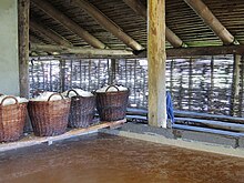
In the Middle Ages the island was famous for its salt production . Here, the salt was extracted from shallow groundwater with a relatively high salt content in evaporated salt pans . The salt marshes of the so-called Rønner on the south side of the island are regularly flooded during winter storms, so that the sandy subsoil there is saturated with seawater . The sand layer, which is only one to two meters thick, is sealed at the bottom with clay . In summer, the salty, shallow groundwater is concentrated by wind and sun, as well as by water extraction by salt-loving plants , to a salinity of up to 17%. Due to its higher density, this brine migrates to the deepest points of the uneven contact surface between clay and sand. From there it was brought to light and evaporated in hundreds of salt-boiler huts. The salt obtained in this way was delivered to Viborg . Due to the high demand for firewood in the salt pans, the island was completely deforested in the late Middle Ages, so that sandstorms buried entire villages (see also → Soil erosion ). In 1652 salt boiling was therefore banned.
The reforestation of the island did not begin until the 1920s, so that today barely a dozen trees on Læsø are more than 100 years old. The reforestation was not without controversy among the population, as many Læsøer lived from beach piracy and were dependent on a clear view in order to detect stranded ships early on. The new trees disturbed the view.
Since the late 1980s, salt boiling huts have been rebuilt and operated as a project for experimental archeology and for tourism. Læsø salt is now available all over Denmark. Since 2002, dermatological products against psoriasis, neurodermatitis and other skin diseases have been made from the brine that is left over from boiling salt.
Churches and architectural features
There are five churches on Læsø, four of them have towers. The church in Byrum has a carillon in the tower, and Læsø's oldest bell hangs in Vesterø Søndre Kirke . It was cast in 1640 by the French bell founder Franciscus Voillardi. The second oldest bell has the Østerby Kirke . It was cast by Hans Meyer in 1658. The larger bell was made in 1955 by the English bell foundry John Taylor & Co. The old bell originally comes from the so-called Hals Kirke . Only a few stones of the Hals Church can be seen today, because shifting dunes have buried this little church. All church bells on Læsø ring together at 6 a.m. The White Church in Vesterø was profaned in 2005 . The nave was torn down, the tower remained as a landmark. A luxurious brine bath was built in place of the nave.
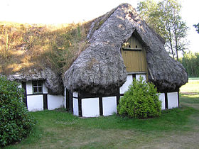
A peculiarity of the island are roof coverings made of seagrass (Danish "bændeltang" ). Since the 1930s, fungal infestation hit the roofs heavily. Today only 20 residential buildings remain, including the museum farm På Lynget and Hedvigs Hus , which can be visited.
Other noteworthy structures
The Kontiskan HVDC line crosses the island of Læsø as an overhead line. There is a 160 meter high radio mast on Læsø .
economy
Major industries on Læsø are tourism, the wool industry and fishing. Especially the Norway lobster ( Nephrops norvegicus , locally, "Jomfruhummer") is one of the main export products of the island; In addition to tourism, “Læsø Fiskeindustri” is the island's largest employer.
traffic
The island can be reached by ferry from Frederikshavn . The island also has an airport with regular connections to Sindal , Aalborg and Copenhagen .
literature
- Steen Andersen, Steen Sjørring (Red.): Det nordlige Jylland (published as the third of five volumes in the Geologisk set series ) - 208 p., Numerous. Fig. And maps, Geografforlaget, Brenderup (DK) 1997 (2nd edition).
- Peter G. Vornlocher: The Danish island of Læsø. A regional geographic study. Self-published, Buckenhof 1998 ( PDF 7.8 MB)
swell
- ↑ a b www.statistikbanken.dk → Befolkning og valg → Folketal → Table BEF44 (Folketal pr. January 1st, demands på byer) .
- ↑ Danmarks Statistics : Statistical Yearbook 2009 - Geography and climate, Table 3 Area and population. Regions and inhabited islands (English; PDF; 39 kB).
- ↑ Danmarks Statistics : Statistisk Aarbog 1920 - Table 3: Arealets Fordeling paa de forskellige større og minre Landsdele including Folkemængde og Befolkningstæthed on February 1, 1916, footnote 9 (Danish / French; PDF; 1.1 MB).
- ↑ Front Punch: The Danish island Læsø. A regional geographic study. 1992 (see literature )
- ↑ Topstenen på Kringelrøn. Photo and brief description of the boulder or the area in which it is located in the gallery of the "Wanderblog" on a private, local history-oriented website (Danish)
- ^ Jens Morten Hansen: Sedimentary history of the island Læsø, Denmark. Bulletin of the Geological Society of Denmark. Vol. 26, 1977, pp. 217-236.
- ^ Niels Oluf Jørgensen: Origin of shallow saline groundwater on the Island of Læsø, Denmark. Chemical Geology. Vol. 184, No. 3, 2002, pp. 359-370.
Web links
- Læsø Kommune (Danish, German, English)
- Ferry connections to the island of Læsø
- Information on salt production (Danish)
- Website of the port of Vesterø (Danish)


