Langeland
| Langeland | |
|---|---|
| Waters | Baltic Sea |
| Archipelago | Danish South Seas |
| Geographical location | 54 ° 56 ' N , 10 ° 47' E |
| length | 52 km |
| width | 11 km |
| surface | 283.84 km² |
| Highest elevation | Skøvlebjerg 46 m |
| Residents | 12,280 (January 1, 2020) 43 inhabitants / km² |
| main place | Rudkøbing |
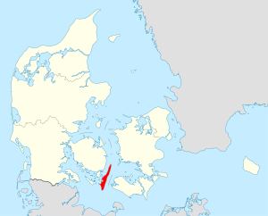
Langeland [ lɑŋəlanʔ ] is a 52 km long and up to 11 km wide Baltic Sea island in the South Denmark in Denmark . It is accessible via a bridging system that the islands Siø and Tåsinge including and to the north-west location Fyn ( dt. : Fyn ) is attached. With 12,280 inhabitants (January 1, 2020) on 283.84 km², the island of Langeland also forms a municipality (since the municipal reform in 2007 ). The Langelandsbelt extends east of Langeland . It is a southern extension of the Great Belt , which forms one of the Danish Baltic Sea accesses. Langeland is part of the island world of the so-called Danish South Sea (in Danish: Sydfynske øhav). On February 12, 2003 there was a referendum only in the Sydlangeland municipality for or against amalgamation island-wide with the other two municipalities. The vote was in favor. There were referendums across the island in 1992 and 2000 , and Sydlangeland was against amalgamation in both.
Geography, Administration and Transport
The 284 km² island of Langeland was originally divided into two Harden , the North ( Langelands Nørre Herred ) and the Südharde ( Langelands Sønder Herred ) in the Svendborg Office , which was divided into three historical administrative districts (municipalities) from north to south with the local reform in 1970 that belonged to the then Fyns office :
- Tranekær
- Here's the Tranekær Castle one of the main attractions. In 1663, the governor and Danish chancellor, Count Friedrich von Ahlefeldt , inherited the rule of Langeland and since then the castle has belonged to his descendants, the Counts of Ahlefeldt -Laurvig. The small port town of Lohals is located on the northern tip of Langeland . The ferry from here to Korsør on Zealand (crossing the Great Belt) was stopped in 1998.
- Rudkøbing
- Rudkøbing is the main town in Langeland municipality and forms the center of the island. Rudkøbing is home to Denmark's most southerly main traffic axis in a west-east direction. The connection to the west is established after the closure of the Svendborg – Rudkøbing ferry connection in 1962 via Langelandsbroen to Rudkøbing, and the connection to the east with the Spodsbjerg – Tårs (island Lolland ) ferry connection . A modern ferry from Rudkøbing to Marstal on the neighboring island of Ærø ran through extremely shallow waters off the west coast of Langeland until January 21, 2013 .
- South Langeland
- The southern part of the island is away from the major traffic routes. In November 2003 the ferry line to Germany ( Bagenkop – Kiel ) with a car / passenger ferry with a capacity of up to 140 cars was finally discontinued, as it could no longer be operated economically after the end of duty-free shopping within the EU ( butter journey ). The former ferry terminal in Bagenkop has now been completely dismantled.
In the course of the Danish administrative reform on January 1, 2007 , these three municipalities were merged to form Langeland municipality .
Several long-distance cycle paths lead across the island, including a. the Baltic Sea Cycle Route , which as EuroVelo route 10 circles the Baltic Sea once.
Localities on the island
The following parishes ( Danish : Sogn ) and villages with over 200 inhabitants ( byer according to the definition of the Danish statistical office ) are located on the island , with a registered population of zero the place had more than 200 inhabitants in the past.
| No. | Parish | Residents | Locality | Residents |
|---|---|---|---|---|
| 18th | Bagenkop Sogn (a) | 530 | Bagenkop | 456 |
| 4th | Bøstrup Sogn | 425 | ||
| 15th | Fodslette Sogn | 92 | ||
| 12 | Fuglsbølle Sogn | 187 | ||
| 1 | Hou Sogn | 535 | Lohals | 446 |
| 14th | Humble Sogn | 1,307 | Humble | 639 |
| 13 | Lindelse Sogn | 733 | Lindelse | 307 |
| 11 | Longelse Sogn | 575 | Spodsbjerg | 214 |
| 17th | Magleby Sogn (a) | 368 | ||
| 8th | Rudkøbing Sogn | 4.016 | Rudkøbing | 4,565 |
| 7th | Simmerbølle Sogn | 722 | ||
| 10 | Skrøbelev Sogn | 644 | ||
| 3 | Snøde Sogn | 337 | Snøde | 288 |
| 2 | Stoense Sogn | 187 | ||
| 9 | Strynø Sogn | 197 |
Strynø Strynø Kalv (b) |
197 0 |
| 5 | Tranekær Sogn | 191 | ||
| 16 | Tryggelev Sogn | 334 | Tryggelev (c) | <200 |
| 6th | Tullebølle Sogn | 1,097 | Tullebølle | 784 |
Remarks
Touristic
Touristic points of interest in South Langeland include the Ristinge - cliff within sight of the island Ærø and the lighthouse Keldsnor Lighthouse near the fishing port and marina Bagenkop at the southern tip of the island. This is where the Langelandsfort is located , a military base during the Cold War . It was converted into a museum in 1993, in which, among other things, two jet fighters ( Saab J-35 Draken and MiG-23 ) can be seen.
archeology
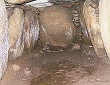
Langeland is interesting because of a number of prehistoric monuments. The passage graves and dolmens in Skovtofte , in Ravnebjerg Skov in Tvedeskov , in Herslev , the mounds of Frellesvig , the long dolmen of Løkkeby and Kong Humbles Grav, the dolmens at Ristinge Nor , Pæregård as well as the Myrebjerg and the Hulbjerg in the south surely protrude below them . There are also the burial mounds in Bremlevænge forest , the ship setting in Konabbe Skov and the settlements of Lindø and Troldebjerg .
geology
On Langeland there are about 690 isolated hills, which despite their relatively low height of only 10 to 20 meters stand out clearly from the flat landscape surrounding them. These hat-shaped hills (Danish: hatbakker) form a unique landscape form and are the island's outstanding element of the landscape. The hills stretch across the island in a long line, with the exception of the Ristinge peninsula. The row of hills continues into the Great Belt and curves from Lohals to Korsør on Zealand. The hills consist mainly of gravel and sand deposited by the meltwater from Ice Age glaciers, with the layers standing upright and sloping towards the center of the hill.
To date there is no reliable explanation about the origin of these hat hills. It is possible that they originated from small lakes that formed on the front part of a stalled glacier. In this section of the glacier, crevices formed in a chessboard-like pattern, a phenomenon known by the Russian word “krevasser”. A small depression was created where the cracks meet at right angles. Gravel, sand and clay were carried into the small basin from the meltwater of the glacier. The more distant active part of the glacier encountered the dead ice with its lakes at a later point in time or drove over it. The layers were folded and the tips of these folds planed off. Some places were covered with boulder clay. When the ice melted, the mounds were left in a long line on a flat surface.
Another geological attraction is Keldsnor in the extreme south of the island. It is a beach lake that emerged from an earlier bay that was cut off from the open sea by a spit hook and stony beach walls.
various
The island's most famous son is the discoverer of electromagnetism, Hans Christian Ørsted .
See also
literature
- Monuments on Langeland (available in German from the Langeland Museum)
- Gunnar Larsen: Fyn og Øerne (published in the Geologisk set series) - 144 p., Numerous. Fig. And maps, Geografforlaget, Brenderup (DK) 2002.
Individual evidence
- ↑ a b statistics banks -> Befolkning og valg -> BEF4: Folketal pr. January 1st demands på øer (Danish)
- ↑ Danmarks Statistics : Statistical Yearbook 2009 - Geography and climate, Table 3 Area and population. Regions and inhabited islands (English; PDF; 39 kB)
- ↑ Suspension of the ferry, last timetable. aeroe-ferry.dk, archived from the original on November 3, 2013 ; Retrieved September 6, 2016 (Danish).
- ↑ admin: Denmark - EuroVelo. Retrieved May 18, 2017 .
- ↑ Statistics banks -> Befolkning og valg -> KM1: Befolkningen January 1st, April 1st, July 1st and October 1st, so and folkekirkemedlemsskab (Danish)
- ↑ Statistics banks -> Befolkning og valg -> BY1: Folketal January 1st efter byområde, alder og køn (Danish)
- ↑ Bill L 27 of October 9, 2008. January 22, 2009, accessed on April 21, 2020 (Danish).


