
Funen
| Funen (Fyn) | |
|---|---|
 |
|
| Waters | Baltic Sea |
| Geographical location | 55 ° 21 ′ N , 10 ° 21 ′ E |
 |
|
| length | 85 km |
| width | 60 km |
| surface | 2 984.56 km² |
| Highest elevation | Frøbjerg Bavnehøj 131 m |
| Residents | 469,947 (January 1, 2020) 157 inhabitants / km² |
| main place | Odense |
 |
|
Fyn (Danish Fyn [ fyːʔn ]) is an island in the Syddanmark region in Denmark . With 2,985 km², Fyn is Denmark's third largest island after Zealand and Vendsyssel-Thy .
geography
Funen lies between the Little and Great Belts . The island is centrally located in Denmark and with 469,947 inhabitants (January 1, 2020), next to Zealand, it is one of the focal points in economic, transport and cultural terms.
North of Funen are the islands of Æbelø , Endelave and Samsø . In the east is the small island of Romsø , in the south, in addition to many smaller islands, the larger islands of Ærø , Tåsinge and Langeland . In the southwest is the island of Helnæs , in the west Bågø and Fænø .
The largest city on Funen is Odense (Denmark's third largest city). The Odense Fjord covers an area of around 63 km². The highest mountain on the island is Frøbjerg Bavnehøj with a height of 131 meters.
administration
From 1970 to 2007, Fyn and its sub-islands formed the Fyns Office , based in Odense. Since then, Funen, the southern third of Jutland and the surrounding smaller islands have been combined to form the Syddanmark region .
traffic
The island is connected to Zealand by a bridge and tunnel construction ( Storebæltsbroen ) and to Jutland and Langeland by bridges . From Nyborg the traffic (cars and trains) goes over the 6.6 km long west bridge to the island of Sprogø . From there trains reach Halskov near Korsør on Zealand through a 7.7 kilometer long, two-tube tunnel. Cars continue to drive over the 6.8 kilometer long east bridge, which spans 65 meters over the shipping route through the Great Belt at its apex. With a span of 1624 meters, it is the longest suspension bridge in Europe. The oldest suspension bridge in Denmark, Ny Lillebæltsbro , connects Funen near Middelfart with Jutland. Langeland is accessible via bridges over the islands of Tåsinge and Siø .
Funen can also be reached by ferry from Alsen and has ferry connections to the small southern islands such as Ærø and Lyø . A fixed connection (bridge) to Alsen is being discussed.
Odense Airport , located in the northern part of the island, is currently only used for charter flights (as of August 2017).
The island is well developed with numerous cycle paths, also for tourists. It is also connected to a number of national and international long-distance cycle routes, including the Baltic Sea Cycle Route , which circles the Baltic Sea as the European EuroVelo route 10.
population
The largest city on Funen is Odense with 180,302 inhabitants. Other important places are Svendborg (27068), Nyborg (17268), Middelfart (15922), Fåborg (6988) and Assens (6016).
climate
|
Average monthly temperatures and rainfall for Funen
Source: Danmarks Meteorologiske Institut (DMI): Normaler for Danmark Klimadata 1961–1990
|
|||||||||||||||||||||||||||||||||||||||||||||||||||||||||||||||||||||||||||||||||||||||||||||||||||||||||||||||||||||||||||||||||||||||||||||||||||||||||||||||||||||||||||||||||||||||||||||||||||||||||||||||||||||||||||||||||
history

The mesolithic dwelling places Møllegabet I and II between Funen and Ærø and Tybrind vig before Middelfart are among the oldest traces of man in the north. The 7000 year old finds come from the Ertebølle culture . The oldest hut layout was found here together with a strange burial in a dugout canoe. The funnel cup culture left behind the earthworks of Sarup and numerous megalithic structures (Alleskov, Ellestedt, Jordløse, Lindeskov and Pipstorn ). The area of Gudme in the southeast of the island yielded finds from the Viking Age of an Iron Age trading and rulership center. From a later time the Ladby ship is an archaeological site of importance.
The oldest document identifying residents of the island is dated to 1085 AD. Until 1300 AD, only about 1/10 of the settlements existing at that time can be proven in documents that have survived. By the 15th century, nine out of 10 villages were recorded in the written sources. It was not until the 16th century that every village and every property was recorded in books.
The settlement of Funen can essentially be divided into three zones:
- the flat inland
- the large forest areas
- the coast
The oldest settlements were close to the coast due to the rich fishing grounds of the Baltic Sea. From 1000 to 1300 AD, the number of villages on Funen doubled. Due to the vulnerability on the coast (by the Slavs ), however, many settlers withdrew to the safer inland and established new settlements there - especially in the forest areas of the island. In the southeast, however, other coastal villages were founded, which were secured by fortifications. These include Nyborg with Magelund or Lykkesholm , Svendborg with Ørkild and Fåborg . Between 1300 and 1450 AD there was stagnation or abandonment of the island and only later did a new wave of settlements occur near the coast, which was favored by the forest belt just two kilometers from the south coast. Fishing settlements in particular also formed on the small islands and headlands.
Funen never formed an administrative unit until 1970. Around 1500 half of the almost 7000 goods on the island belonged to the aristocracy, a quarter to the church and the remaining quarter to the Danish crown. When the future King Christian VIII was ousted from the Norwegian throne in 1816, his cousin King Frederik VI. appointed him governor of Funen , which was more of an honorary title than an administrative function. While Funen was divided into numerous feudal districts since the Middle Ages, in the 20th century it only consisted of the offices of Odense and Svendborg. In 1970 these were merged into Fyn's office . The island's coat of arms is three hop leaves. In 2007, however, Fyn became part of the Syddanmark region .
etymology
In Old Icelandic texts, the island was called Fjón . Adam of Bremen called it Fune in 1075 AD . In 1231 AD it was called Fyun , in Latin it was called Fionia and Feonia and the Low Germans called it Vüne . When Hans Christian Andersen was asked what Fyn - as it is spelled in Denmark today - means, he answered with poetic freedom: "fin". That means “fine” in German. Besides this etymology there is another. After that there should have been a King Fin (Finn) who is said to have defended his country well.

Enebærodde lighthouse


Culture
The artist colony of the Funen painters began in Kerteminde and Faaborg by Johannes Larsen , Fritz Syberg and Peter Hansen and was later continued as a center in Møllebakken.

Fritz Syberg: Børnene på Fyns Hoved (1905)
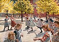
Peter Hansen: Legend børn. Enghave plads (1908)


Individual evidence
- ↑ a b statistics banks -> Befolkning og valg -> BEF4: Folketal pr. January 1st demands på øer (Danish)
- ↑ Danmarks Statistics : Statistical Yearbook 2009 - Geography and climate, Table 3 Area and population. Regions and inhabited islands (English; PDF; 39 kB)
- ↑ Foreningen Als-Fyn Broen (Alsen-Fyn Bridge Association)
- ↑ Fyn and the surrounding islands are perfect for a cycling holiday . In: Visitfyn . ( visitfyn.com [accessed May 18, 2017]).
- ↑ translator2: Countries - EuroVelo. Retrieved May 18, 2017 .