Lyø
| Lyø | ||
|---|---|---|
| Lyø Kirke | ||
| Waters | Baltic Sea | |
| Archipelago | Danish South Seas | |
| Geographical location | 55 ° 2 '40 " N , 10 ° 8' 52" E | |
|
|
||
| surface | 6.05 km² | |
| Highest elevation | 24 m | |
| Residents | 81 (January 1, 2020) 13 inhabitants / km² |
|
| main place | Lyø By | |
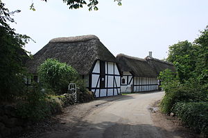
| Village street with residential houses | ||
Lyø or Lyö is an egg-shaped, max. 24-meter Danish Baltic Sea - island in the so-called " Danish South Sea ", south of Funen , about seven kilometers from Faaborg located.
history
The island forms its own parish Lyø Sogn , which originally belonged to Harde Sallinge Herred in what was then Svendborg . From 1970 it belonged to the Faaborg municipality in the Fyns office , which was merged with the municipal reform on January 1, 2007 in the Faaborg-Midtfyn municipality in the Syddanmark region. Lyø belongs to the Association of Danish Small Islands .
81 residents live on the 6.05 km² island (January 1, 2020).
In 1223 the Danish King Waldemar II (Sejr) and his son were captured here by Count Heinrich von Schwerin and brought to the Waldemarturm of Dannenberg Castle .
Lyø By
There is only one central place on Lyø called Lyø (or Lyø By). With its five village ponds, it is one of the most beautiful villages in Denmark, where you can see hand-blown window panes and wooden locks in the doors. The only surviving circular cemetery in Denmark is located around the church. Like several of the southern Funen country churches, the church has stepped gables on the choir , Karnhaus and church tower .
Lyø Mill
Lyø Mill is located on the highest point on the island. For many years there was an old post mill (1821–1876) at this point, it was previously in Fåborg and before that on Ærø. In 1876 it was torn down and replaced by today's Dutch mill. The mill is privately owned and used as a residential building.
Attractions
Are typical of willows lined hiking and biking trails. Lyø offers hiking and cycling opportunities as well as relatively secluded beaches. The port, two kilometers from the town, is a popular meeting place for sailors. On the flat, swept up north beach (the reef or Revet) lies “Anes Kiste”, one of Denmark's largest boulders , around which an old legend is woven. On the island are the Runddysser Bøjeshøj and Vesterryds Høj, the Klokkestenen from Lyø and Kong Lavses Grav and in the east of the Store Stenshøj, five ancient megalithic structures of the funnel cup culture (TBK). The highest point is 24 meters above sea level.
traffic
There is a ferry connection to Fåborg via Avernakø .
See also
Individual evidence
- ↑ a b statistics banks -> Befolkning og valg -> BEF4: Folketal pr. January 1st demands på øer (Danish)
- ↑ Danmarks Statistics : Statistical Yearbook 2009 - Geography and climate, Table 3 Area and population. Regions and inhabited islands (English; PDF; 39 kB)
Web links
- Web presence
- Lyø Island (German)
- Anes kiste (Danish)


