Endelave
| Endelave | ||
|---|---|---|
| Endelave Church | ||
| Waters | Kattegat | |
| Geographical location | 55 ° 45 '35 " N , 10 ° 17' 46" E | |
|
|
||
| length | 6.7 km | |
| width | 2.4 km | |
| surface | 13.08 km² | |
| Residents | 155 (January 1, 2020) 12 inhabitants / km² |
|
| main place | Endelave | |
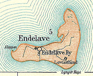
| Map from 1900 | ||
Endelave is a Danish island in the southwestern part of the Kattegat , north of Fyn ( dt. : Funen ) and about 10 km from the Jutland mainland. The island is low and flat. Its size is 13.08 km². Endelave has 155 inhabitants (as of January 1, 2020).
Since the Danish municipal reform of 1970 to form the Horsens Municipality in what was then Vejle Amt , which was merged into the “new” Horsens Municipality in the Midtjylland region on January 1, 2007 , the island has its own parish, Endelave Sogn , which until 1970 belonged to Harde Nim Herred in the Skanderborg office .
Four areas are distinguished on Endelave:
- Endelave (locality)
- Cock (west)
- Lynger Hage (south)
- Øverste Ende ("Upper End", North)
With the ferry , the island of is Snaptun ( East Jutland ) can be reached in 55 minutes. The island also has a small private runway of around 600 m for small planes.
Endelave is part of the Association of Danish Small Islands .
See also
Individual evidence
- ↑ a b statistics banks -> Befolkning og valg -> BEF4: Folketal pr. January 1st demands på øer (Danish)
- ↑ Danmarks Statistics : Statistical Yearbook 2009 - Geography and climate, Table 3 Area and population. Regions and inhabited islands (English; PDF; 39 kB)


