Strynø
| Strynø | ||
|---|---|---|
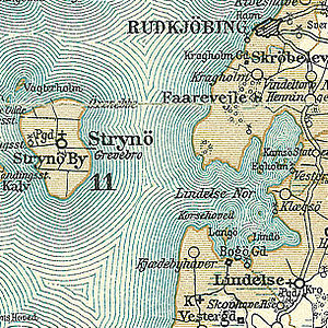
| Strynø and Lindelse Nor on a map from around 1900 | ||
| Waters | Baltic Sea | |
| Archipelago | Danish South Seas | |
| Geographical location | 54 ° 54 '20 " N , 10 ° 36' 30" E | |
|
|
||
| length | 3.2 km | |
| width | 2.2 km | |
| surface | 4.88 km² | |
| Residents | 197 (January 1, 2020) 40 inhabitants / km² |
|
| main place | Strynø By | |
Strynø is a Danish island in the " Danish South Seas " south of Tåsinge between Langeland and Ærø .
Together with some uninhabited offshore islands (including Strynø Kalv ), the island forms a separate parish ( Danish : Sogn ) Strynø Sogn , which belonged to Harde Sunds Herred until the Danish administrative reform in 1970 , then to what was then Rudkøbing Kommune in Fyns Amt , which was part of the Local reform on January 1, 2007 in the Langeland municipality in the Syddanmark region.
The island has an area of 4.88 km² and 197 inhabitants (January 1, 2020) The island has a ferry dock with a boat harbor at the end of a 300 m long dam on the eastern bank. There is a ferry connection to Rudkøbing .
Strynø belongs to the Association of Danish Small Islands .

