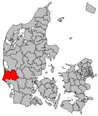
Varde commune
|
|
|||
|
|||
| Basic data | |||
|---|---|---|---|
| State : | Denmark | ||
| Region : | Syddanmark | ||
| Region : | Sydjylland | ||
| Educated: | 2007 | ||
| former municipalities : (until the end of 2006) |
Varde commune Blaabjerg commune Blåvandshuk commune Helle commune Ølgod commune |
||
| Office (until the end of 2006) : | Sønderjyllands Amt | ||
|
Harden : (until March 1970) |
Vester Hørne Herred Øster Hørne Herred Skast Herred |
||
| Office (until 1970) : | Ribe office | ||
| Residents : | 49,961 (2020) | ||
| Area : | 1,240.10 km² (2014) | ||
| Population density : | 40 inhabitants per km² | ||
| Municipality number : | 573 | ||
| Administration headquarters: | Varde | ||
| Post Code: | 2640, 6753-6870, 8541 | ||
| Address: | Bytoften 2 6800 Varde |
||
| Mayor: | Erik Buhl Nielsen ( Venstre ) |
||
| Website: | www.vardekommune.dk | ||

|
|||
Varde Kommune is a Danish municipality in western Jutland . It was created on January 1, 2007 in the course of local government reform by merging the previous municipalities of Varde , Blaabjerg , Blåvandshuk , Helle and Ølgod in the Sønderjyllands Amt .
Varde municipality has a total population of 49,961 inhabitants (as of January 1, 2020) and an area of 1,240.10 km². It is part of the Syddanmark region .
Parish communities and localities in the municipality
The following parish communities ( Danish : Sogn ) and localities with more than 200 inhabitants ( byer according to the definition of the Danish statistical authority ) are located in the municipality ; Population on January 1st, 2020, with a registered population of zero, the place had more than 200 inhabitants in the past:
- ↑ a b c d On November 27, 2016, Ho Sogn , Oksby Sogn and Mosevrå Sogn (until October 1, 2010: Mosevrå Kirkedistrikt (German: church district) in Oksby Sogn) were merged into Blåvandshuk Sogn . This only applies to church issues. In its capacity as Matrikelsogne , i.e. as land register districts of the cadastral authority Geodatastyrelsen , such changes have not had any effect since the abolition of the Harden structure in 1970.
- ↑ Henne Stationsby had fewer than 200 inhabitants for the first time in 2010.
Web links
Commons : Varde Kommune - Collection of images, videos and audio files
Individual evidence
- ↑ a b c d statistics banks -> Befolkning og valg -> BY1: Folketal January 1st efter byområde, alder og køn (Danish)
- ↑ a b Statistics Banks -> Geografi, miljø og energi -> ARE207: Areal demands efter municipality / region (Danish)
- ↑ danskekommuner.dk: Borgmesterffekta: Varde (Danish), accessed on April 25, 2020
- ↑ Statistics banks -> Befolkning og valg -> KM1: Befolkningen January 1st, April 1st, July 1st and October 1st, so and folkekirkemedlemsskab (Danish)

