
Oksbøl (Varde Municipality)
| Oksbøl | |||||
|
|||||
| Basic data | |||||
|---|---|---|---|---|---|
| State : |
|
||||
| Region : | Syddanmark | ||||
|
Municipality (since 2007) : |
Varde | ||||
| Coordinates : | 55 ° 38 ′ N , 8 ° 17 ′ E | ||||
|
Population : (2020) |
2,837 | ||||
| Postal code : | 6840 Oksbøl | ||||
.jpg) Eel Kirke |
|||||


Oksbøl is a small Danish town in the municipality of Varde in the Syddanmark region . In the west by Vejers Strand , in the north by the towns of Vrøgum and Jegum, in the east by Billum and in the south by the Ho Bugt .
Infrastructure
Oksbøl has a central function for the surrounding settlements with a train station on the Varde – Nørre Nebel railway line , a post office, a bank and several supermarkets .
Oksbøl has a barracks for the Danish army and a youth hostel.
The privately operated fire brigade museum shows Danish fire engines from the 20th century in three halls. Tanks of the Danish army after World War II are exhibited in another hall. The Amber Museum has moved to the museum complex at Tirpitz in neighboring Blåvand .
The oldest parts of the Aal Kirke , known for its frescoes , were built in the 10th century.
Refugee camp and war cemetery
The Oksbøl refugee camp housed up to 35,000 German refugees and displaced persons between 1945 and 1949. In the German war cemetery in Oksbøl, dead people from the Second World War and those from the camp are buried.
photos

railway station
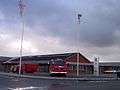
Fire Brigade Museum

Church chancel

inner space


.jpg)
.jpg)
Web links
- German war cemetery: Oksböl. In: volksbund.de .
- Godeke Klinge: Military training area and refugee camp Oksböl - yesterday, today and tomorrow. In: geschichtsspuren.de. 2017 .
- Flygtningelejren: Danmarks Flygtninge Museum undervejs. (German, Danish, English, refugee camp: Denmark's refugee museum on the way).
- Amber Museum in Oksbøl (German, Danish, English)
Individual evidence
- ↑ Statistics banks -> Befolkning og valg -> BY1: Folketal January 1st efter byområde, alder og køn (Danish)
- ^ Gert Ravn, Hanne Schwarz: Aal Kirke , Oksbøl, 2012