Hvannadalshnúkur
| Hvannadalshnúkur | ||
|---|---|---|
|
The Öræfajökull massif as seen from Skaftafell |
||
| height | 2110 m | |
| location | Iceland | |
| Mountains | Öræfajökull | |
| Coordinates | 64 ° 0 ′ 51 " N , 16 ° 40 ′ 38" W | |
|
|
||
| Type | Lava dome | |
| rock | predominantly rhyolite | |
| Age of the rock | 700,000 years | |
| Last eruption | 1727 (active) | |
| First ascent | July 19, 1813 by Hans Frisak and Jón Árnason | |
| Normal way | over the valley glacier Virkisjökull | |
|
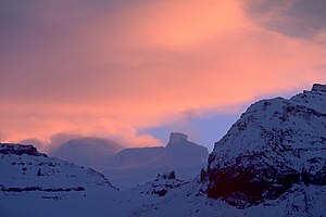
Sunrise at Hvannadalshnúkur |
||
The Hvannadalshnúkur ['kʰvanːataˑlsˌn̥uːkʏr̥] in the volcanic massif of Öræfajökull is the highest peak in Iceland at 2,110 m . It is located in the southeast of Iceland in the municipality of Hornafjörður .
Height measurements
For a long time it was considered to be 2,119 m high, but after a new measurement on August 4, 2005 , the height was corrected downwards. It doesn't even have to be a measurement error. Changes in height and width are not uncommon in volcanoes . When a magma chamber under the volcano fills, it expands z. B. on. On the other hand, every further eruption can increase or decrease the height of the mountain - as last happened in 2000 with the Icelandic volcano Hekla - such as the eruption of Mount St. Helens in the USA in 1980.
Hvannadalshnúkur and Öræfajökull
Hvannadalshnúkur is located in Skaftafell National Park and is part of the Öræfajökull glacier, which is part of Vatnajökull .
At the same time, however, Öræfajökull is a mighty central volcano . The volcano was formed mainly during the Pleistocene in eruptions under the ice and also in ice-free times.
Two strong outbreaks have been documented since Iceland was settled ( 1362 and 1727 ), which temporarily put an end to settlement in the area.
summit
On the summit of Öræfajökull there is a 5 km wide and 550 m deep caldera that is filled with glacial ice and from which nine valley glaciers extend down to the plains. Fourteen mountain peaks tower on the edge of this caldera, all over 1,500 m high, three of which are among the highest in the country. The Hvannadalshnúkur is located in the northwestern corner of the summit caldera of Öræfajökull.
Its summit is a largely ice-covered hill of acidic, i.e. H. silicate-rich volcanic rock on the edge of the relatively small caldera. It towers over the plateau formed by ice by about 200 m.
Surname
The name of the summit means summit of the valley of angelica (isl. Hvönn ). The valley lies above the Svínadalur and below the Hvannadalshryggur ridge . In the direction of Svínadalur, the terrain from Hvannadalshnúkur drops very steeply and numerous valley glaciers extend from this down into the plain.
Landmark
You can see the volcano from afar, as it is located almost exactly on the south-eastern tip of the country. The planes arriving from Europe usually steer exactly towards the mountain and turn west at its height in order to follow the course of the south coast to Keflavík , where the international airport is located.
Ascent
The Norwegian Hans Frisak and the Icelandic Jón Árnason climbed the summit for the first time on July 19, 1813. However, a long period of time passed without further attempts until FW Howell climbed the mountain in 1896. At the beginning of the 21st century, the mountain is one of the most popular destinations in Iceland for alpinists.
The summit can be reached via the glacier. Ari Trausti suggests B. suggest two ascent routes from the southwest, one over Virkisjökull , the other over the upstream Sandfell mountain.
See also
Web links
- Painting "Öræfajökull" by Jón Stefánsson in the National Gallery
- Oraefajokull in the Global Volcanism Program of the Smithsonian Institution (English)
- Oraefajokull near Oregonstate (English)
Individual evidence
- ↑ Oraefajokull in the Global Volcanism Program of the Smithsonian Institution. Retrieved September 15, 2010
- ↑ GVP, ibid.
- ^ Ari Trausti Guðmundsson, Pétur Þorsteinsson: Íslensk fjöll. Gönguleiðir á 151 tind. Reykjavík 2004, p. 134
- ↑ Ari Trausti, ibid.
- ↑ mbl.is ; Retrieved August 5, 2012
- ↑ Íslandshandbókin. 2. bindi. 1989, p. 686
- ↑ Ari Trausti Guðmundsson , ibid., Pp. 134–35.


