Morsárfoss
| Morsárfoss | ||
|---|---|---|
|
View from the Kristínartindar peaks to the Morsárfoss in the rock in the center of the picture; The Vatnajökull ice cap lies on the rocks , and Morsárjökull begins below them . |
||
| Coordinates | 64 ° 6 '44.7 " N , 16 ° 53' 5.3" W | |
|
|
||
| place | Morsárjokull , Vatnajokull National Park , Iceland | |
| height | 227 m | |
| Estuarine waters | → Morsálón → Morsá | |
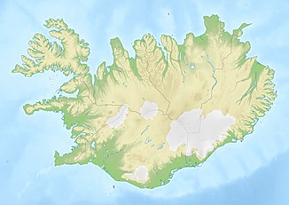
The Morsárfoss is the highest waterfall in Iceland with a height of about 227 meters . It is located within the Vatnajökull National Park in the Hornafjörður municipality in the Austurland region in southeast Iceland .
The Morsárfoss was first observed in 2007 and measured in 2011. With the height mentioned, it exceeds the Glymur , which has long been considered the highest waterfall in Iceland, by around 30 meters. The actual height of the Morsárfoss, i.e. H. including the parts covered by ice at the upper and lower part of the waterfall, is estimated to be more than 240 meters.
Surname
Morsárfoss is an Icelandic place name which means "waterfall of the Morsá". Morsá is the name of the river that flows from the meltwater of the Morsárjökull glacier, onto which the Morsárfoss falls, and whichflowsinto the Skeiðará after a few kilometers.
This name has been in effect since August 14, 2011. He was determined by a referendum carried out by the daily Morgunblaðið from June 14th to 30th, 2011. In 1991 responses were received in which 986 different names were suggested. Morsárfoss was the most popular proposal with 119 mentions, followed by Klettafoss ("Felsfall") and Morsi with 56 mentions each. 50 mentions were given to the proposed name Jökulfoss ("glacier fall "), 45 to Morsárfossar . The majority of the suggested names referred to the height of the waterfall, the noise it emits, its characteristics of protruding under a glacier or being half-covered by ice, or place names in its vicinity. The geologist Jón Viðar Sigurðsson, who was jointly responsible for the height measurement, also suggested the name Þrymur , a term from the Nordic world of legends that alludes to the noises made by the ice blocks that often fall at the waterfall, and the sound it makes to the Name Glymur remembers.
Location, origin and appearance
Morsárfoss is located at the point where the Morsárjökull glacier tongue branches off from the Vatnajökull plateau glacier . There is an almost vertical rock wall originally hidden under the glacier ice, which is over a kilometer long and approx. 240 m high. Presumably as a result of global warming , the Morsárjökull has melted within a few decades to such an extent that its connection to the Vatnajökull is broken in its central part. This brought the rock face to light and the Morsárjökull now begins "out of nowhere" at the foot of the rock face. It flows, wedged between two mountains , about three and a half kilometers to the valley and brings out the small river Morsá at its end .
The plateau that ends at the rock face continues to be covered by Vatnajökull. Parts of its meltwater flow under the ice on the rock plateau. At the upper edge of the rock face, the water emerges from under the ice and immediately falls in a main and several smaller watercourses down to the Morsárjökull, which begins below. There it has created a ten to fifteen meter deep depression between the ice and the rock. On the other hand, at the foot of the waterfalls, there is a kind of alluvial ice cone , formed by the Séracs , who often fall over the edge of the rock. It is also the falling blocks of ice that forbid you to go right up to the waterfall, for example to determine its height directly.
Access
The easiest vantage point to see Morsárfoss is on Kristínartindar Mountain , the summit of which is six kilometers south of the waterfall as the crow flies. You can reach the mountain after several hours of walking from the former Skaftafell National Park Center via the Svartifoss and Skaðafoss waterfalls .
The waterfall can also be reached by a glacier hike following the Morsárjökull uphill. However, this requires adequate equipment.
Height determination
The first altitude determination was an estimate made on June 12, 2011, which was 228 meters. On June 29th, the geologist Jón Viðar Sigurðsson, the head of the Lónsöræfi Unnur Jónsdóttir nature reserve and the Vatnajökull National Park ranger Guðmundur Ögmundsson undertook an expedition in which they took three measurements at three different locations and came to the conclusion that the visible height of the Waterfall is 227.3 meters, while the total height, taking into account the parts covered by ice, should be more than 240 meters.
See also
Web links
Notes and individual references
- ↑ a b c d Iceland’s Tallest Waterfall Might Lose Its Status in Iceland Review on June 16, 2011
- ↑ a b c d e f g h i j k l m n o New Glacial Waterfall in Iceland 240 Meters High in Iceland Review on July 8, 2011
- ↑ a b Iceland’s Tallest Waterfall to be Named in Iceland Review on July 19, 2011
- ↑ a b c Stórfenglegir fossar í klettabelti innst á Morsárjökli in Morgunblaðið on June 14, 2011

