Snæfellsjökull National Park
| Snæfellsjökull National Park | ||
|---|---|---|
| Snæfellsjökull | ||
|
|
||
| Location: | Iceland | |
| Next city: | Grundarfjörður | |
| Surface: | 170 km² | |
| Founding: | June 28, 2001 | |
| Saxhóll Crater | ||
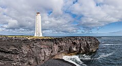
| Lóndrangar | ||
| Malarrif | ||
The Snæfellsjökull National Park is located in the west of Iceland at the westernmost end of the Snæfellsnes peninsula and is one of three national parks in the country.
General
The national park was established on June 28, 2001 to protect the natural treasures around the Snæfellsjökull glacier volcano and the remains of human settlements - such as the remains of winter fishing huts at Dritvík - in the area and make them accessible to the general public.
The national park covers 170 km² and includes the extreme western part of the Snæfellsnes peninsula. The eastern border of the national park initially runs from approx. 1 km west of the Dagverðarnes airfield to the north, then turns slightly to the east around the Snæfellsjökull glacier, which is almost entirely within the national park, and then again to the north. At the eastern Geldingafell , the border makes a sharp bend to the west, from the western Geldingafell it runs in an arc to the north-northwest and reaches the sea approx. 1 km west of Hellissandur .
The main office is in Hellissandur, an exhibition space since 2004 in Hellnar . A national park attendant is responsible for the national park, in the summer months there are other employees who, for example, look after the exhibition rooms in Hellnar or take guided hikes in the national park, etc. a. up on the glacier.
Snæfellsjökull volcano and the area's volcanism
Snæfellsjökull volcano is an old central volcano that has shaped the area here for many millennia.
Its last eruptions were around 4,000 and 1,750 years ago.
It has been proven that it also produced smaller glowing clouds and glacier runs .
The many craters and lava fields in the area can be traced back to the eruptions in this volcanic system, such as the craters Saxhóll or Hólahólar .
Some eruptions have been shown to have taken place during the Ice Age. For example, Bárðarkista and the hills to the north of today's glacier were created under an Ice Age glacier and are therefore made of palagonite .
Lóndrangar is an old eruption channel , Svalþúfa part of a crater, which, like the island of Surtsey , was probably formed by a submarine eruption.
On the settlement history of the area
The area was already settled at the time of the conquest. Its advantages were quickly recognized, especially in the very rich fishing grounds around the tip of the Snæfellsnes peninsula.
This explains why this was one of the most densely populated areas in all of Iceland in the 18th century. Numerous fishing villages with a rather poor population were located here, for example up to 600 men lived in Dritvík during the fishing season and around 200 people were permanent residents there at the time.
Today the area from Hellnar to Gufuskálar is uninhabited.
Fauna and flora in the national park
The soil of the area is very porous and therefore, like in the Icelandic highlands, to which the area is sometimes included, the water quickly seeps into the soil. Nevertheless, there is considerable vegetation on the hills and in the lava fields.
Numerous types of moss have settled here. As in other Icelandic areas, the trees do not grow tall, but you can find dwarf birch and white willow.
Some plants are protected, for example the meadow quail wheat and the single berry .
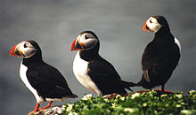
Many seabirds breed here, especially on the sea cliffs. So you can, for example, on Þúfubjarg puffins , kittiwakes and fulmars observed. Some sea eagles also have their nests in the mountains further inland.
Like them, martens and arctic foxes feed on the smaller birds and their eggs.
Hiking trails
Numerous marked hiking and riding trails criss-cross the park. They often follow the old mule tracks, which were the only connecting routes here until the beginning of the 20th century.
See also
- History of Iceland
- Volcanoes in Iceland
- List of national parks in Iceland
- Þingvellir National Park
- Vatnajokull National Park
- Jökulsárgljúfur National Park
Web links
- Website of the national park on the website of the environmental authority (English, Icelandic)
- Risk studies at Snæfellsjökull, Univ. v. Iceland (Engl.)
- Snæfellsjökull National Park in the Global Volcanism Program of the Smithsonian Institution (English)


