Ólafsvík
| Ólafsvík | ||
|---|---|---|
|
|
||
| Coordinates | 64 ° 54 ′ N , 23 ° 42 ′ W | |
| Basic data | ||
| Country | Iceland | |
| Vesturland | ||
| ISO 3166-2 | IS-3 | |
| local community | Snæfellsbær | |
| Residents | 1000 (January 1, 2019) | |
|
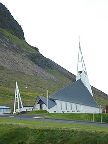
Ólafsvík, in the background Mount Enni
|
||
Ólafsvík is a town in the north-west Icelandic municipality of Snæfellsbær with 1000 inhabitants (as of January 1, 2019).
geography
Ólafsvík is located on the western tip of the Snæfellsnes peninsula on Breiðafjörður and is dominated by the 415 meter high table volcano Ólafsvíkurenni .
The stratovolcano Snæfellsjökull is located southwest of Ólafsvík . In the east of Ólafsvík, the pass road leads over the Fróðárheiði plateau to Búðir in the south of Snæfellsnes .
history
Beginnings as a trading and fishing place
According to the land register, Ólafur belgur is the first settler of Ólafsvík .
A settlement formed at this point early on. This was due to the excellent fishing grounds and the favorable landing spot for the rowing boats.
Ólafsvík is the first Icelandic place that - in the 17th century, more precisely 1687 - received a trading license from the Danish king. Ólafsvík remained an important trading center until the 19th century.
The sailing ship Svanen
In the 18th and 19th centuries, a sailing ship, the Svanen , built in Eckernförde in 1777/78 from Ólafsvík , maintained the connection between Iceland and Western Europe. It finally sank in a storm in the port of Ólafsvík in 1891. Your shipowner was the most important merchant of the place and at that time the area, Hans A. Clausen . The folk poet Steingrímur Þorsteinsson sailed on the Svanen, which inspired him to write a famous poem about Snæfellsjökull.
school
In 1887 one of the first public schools in Iceland was opened in Ólafsvík. For 30 years the so-called Skólasjóð (school fund) had been collected for its construction. A sports hall and swimming pool were not added until 1970.
Parish
Ólafsvík is the seat of a parish priest. The church was initially in Fróðá, and from 1892 in the village. The current church was completed in 1967. With its fish shape, it also symbolizes the wealth of the place and was designed by Hákon Hertervig. A sermon chair inside comes from the Fróðár Church and was given to it in 1710. The colorful church windows are the work of the artist Gerður Helgadóttir .
20th and 21st centuries
Around 1900 Ólafsvík was one of the largest villages in Iceland. But from 1905 he was troubled by the lack of a port accessible to motor ships. Such was only built in the 1960s.
Located on a semicircular bay, the place is now important for fishing and a trading center for the farmers in the area.
On April 1, 1990, the rural community Fróðárhreppur was incorporated into Ólafsvík. The municipality Ólafsvík ( Isl. Ólafsvíkurbær ) lost its independence on June 11, 1994. It formed the new community Snæfellsbær with the rural communities Staðarsveit, Breiðuvíkurhreppur and Neshreppur .
More Attractions
In Gamla Pakkhúsið , the oldest house in the town from 1844, there is a small museum.
Transport links
For centuries Ólafsvík was considered a relatively difficult place to reach.
The boat dock was exposed to northern storms. Therefore, from the Middle Ages to the beginning of the 17th century, the main trading port of the area was in the Rif to the north .
Roads for vehicles were not known in the area until the beginning of the 20th century. There were routes across the Fróðárheiði between the south and north of the Snæfellsnes peninsula . But the area is notorious even today for the particularly violent (winter) storms.
To the west in the direction of the Rif the steep and eroded mountainside of Ólafsvíkurenni (410 m) blocked the way. The path around him led on a stretch of about 1200 m over rocks that could only be crossed with difficulty at low tide. Rockslides, landslides and, in winter, snow avalanches threatened from above. The mountain is the subject of a poem by the Icelandic romantic Jónas Hallgrímsson . On the eastern side, getting through before Road 54 was built wasn't easier either. There the eroded outcrop of Búlandshöfði blocked the way.
An unpleasant troll woman is said to have lived in Ólafsvíkurenni at the time of the conquest. According to legend, she took on Ingjaldur , the first settler in the area, and pelted him with stones on his Ingjaldshóll farm .
The first path that was passable with normal cars was only blasted into the slope in 1963. The road that exists today dates from 1983. Old road connections can be clearly seen above and below.
Daughters and sons
- Erró (* 1932), painter
- Jóhann Jónsson (1896–1932), writer
Population numbers (Ólafsvíkurhreppur)
| date | Residents |
|---|---|
| 1920: | 442 |
| 1980: | 1,180 |
| 2011: | 1,020 |
Town twinning
See also
Web links
- To the church at Ingjaldshóll / Ólafsvík , Icelandic
- Tourism West Iceland, English.
- Tómas Jóhannesson: Supporting structures stopped most of an avalanche, Icelandic Met Office, News, April 27, 2012 (English)
- Lúðvik Kristjánsson: Ólafsvík 250 ára . In: Lesbók Morgunblaðsins , March 21, 1937, pp. 84–87. (Icelandic)
Individual evidence
- ↑ Íslandshandbókin. 1. bindi. 1989, p. 174
- ↑ image under [1]
- ^ Einar Haukur Kristjánsson: Snæfellsnes norðan fjalla. Ferðafélag Íslands. Árbók 1986, pp. 20f.
- ↑ Íslandshandbókin , ibid.
- ↑ Íslandshandbókin , ibid.
- ^ Einar Haukur Kristjánsson: Snæfellsnes norðan fjalla. Ferðafélag Íslands. Árbók 1986, p. 16
- ↑ Report on the state of the road at the beginning of the 19th century.
- ↑ Ólafsvíkurenni , 1847, text: Icelandic. Retrieved May 22, 2012.


