Búlandshöfði
| Búlandshöfði | ||
|---|---|---|
|
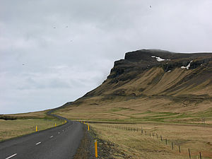
Búlandshöfði from the west |
||
| height | 326 m | |
| location | Iceland | |
| Mountains | Höfðakúlur | |
| Coordinates | 64 ° 56 ′ 0 ″ N , 23 ° 29 ′ 0 ″ W | |
|
|
||
| Type | Promontory | |
| rock | v. a. Sediment layers | |
| particularities | Sea sediments with shells from the Ice Age | |
|
View from Búlandshöfði to the west and Ólafsvík |
||
Búlandshöfði is a cape 325 m high in the west of Iceland . It is located in the north of the Snæfellsnes peninsula on the banks of the Breiðafjörður fjord between the towns of Ólafsvík and Grundarfjörður . The cape belongs to the mountain Höfðakúlur , which rises to 597 m. Behind these smaller mountains lies the volcanic mountain massif Helgrindur with its highest mountain Kaldnasi (985 m).
Búlandshöfði traffic obstacle
Before Road 54 was built in the early 1960s, the cape was a significant obstacle to traffic.
There were only two options if you wanted to go around the cape: One path lay over eroded slopes at a height of 111 m and in some places was so narrow that two people or horses could not pass each other. Here you always got off the horse and let the animals find their own way. The other path was down at the foot of the rock outcrop and could only be done on foot at low tide, whereby you had to climb over slippery rocks similar to the Enni on the other side of Ólafsvík.
Legends about Cape Búlandshöfði
One legend - part of the Icelandic saga Eyrbyggja - tells of two slaves who tried to escape this way after a battle. They mistook their masters, who followed them and wanted to help, to be the enemy. Because they had seized some of the horses on the other side. In their fear they should have crashed at the Cape.
On the other hand, another story tells of a woman who looked for sheep here. She would have found one, wanted to hold onto it, and crashed a little with the animal. However, both would have got stuck in the rock just in front of the actual 88 m high cliffs and were saved at the last second.
geology
At Cape Búlandshöfði you can find layers of sediment around a million years old and 30 to 50 meters thick at a height of 135 to 180 meters above sea level.
Below are tillite and sea sediments with mussel shells from the Arctic Ocean . They come from a cold period of the last ice age .
Above this, one can find marine sediments with mussels that live at temperatures similar to those we have now ( warm period ).
At the very top you can find layers of lava (the land rose from the sea) that have been abraded by the glacier (another glacial period ).
The difference in altitude between the sea level then and now is explained not only by the fact that the sea level was actually higher in some cases due to the melting of the glaciers, but also by the fact that the land lifted after the ice age glaciers melted (around 10,000 years ago in Iceland) because of the load of the glacier no longer lay on him.
The same mussel species were found at a similar height on other mountains in the area.


