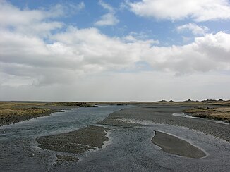
Kúðafljót
| Kúðafljót | ||
|
The river before the pseudocraters of Álftaver |
||
| Data | ||
| location | Southurland ( Iceland ) | |
| River system | Kúðafljót | |
| source | on the Mýrdalsjökull glacier 63 ° 37 ′ 50 ″ N , 19 ° 3 ′ 0 ″ W |
|
| Source height | approx. 1350 m | |
| muzzle | North Atlantic east of Vík í Mýrdal Coordinates: 63 ° 35 ′ 50 ″ N , 18 ° 22 ′ 0 ″ W 63 ° 35 ′ 50 ″ N , 18 ° 22 ′ 0 ″ W |
|
| Mouth height | 0 m | |
| Height difference | approx. 1350 m | |
| Bottom slope | approx. 12 ‰ | |
| length | 115 km | |
| Left tributaries | Eldvatn | |
| Right tributaries | Tungufljót (Mýrdalssandur) , Hólmsá , Skálm | |
| Communities | Álftaver , Meðalland | |
| Risk of glacier runs | ||
|
Rivers of Skaftá (left) and Kúðafljót (right) |
||
The Kúðafljót is a river in the south of Iceland . It is one of the largest glacial rivers in the country.
Surname
The Landnámabók reports that the name comes from the ship Vilbalds , one of the first settlers in Skaftátunga . The name of the ship was Kúði .
Location and tributaries
It flows east of the Mýrdalsjökull through the Skaftátunga district and flows into the Atlantic in the Álftaver district over the Mýrdalssandur after it has taken up numerous tributaries, the most important of which are Hólmsá , Tungufljót and Eldvatn . One arm of the Skaftá also extends to Kúðafljót. Parts of the waters of the Skaftá seep into the stacked lavas of the Eldhraun (origin: Laki ) and Eldgjáhraun on the Mýrdalssandur and reappear in the Eldvatn.
Amount of water
The average amount of water is 230 m³ / s, the lowest value was 110 m³ / s, the highest value measured so far was 2000 m³ / s.
The Kúðafljót is also one of the rivers whose water level can indicate volcanic activity of the Katla under Mýrdalsjökull. Therefore it is very well monitored. The Icelandic Meteorological Institute, IMO, controls the Hólmsá, Eldvatn and Skálm tributaries.
If the Katla volcano erupts below Mýrdalsjökull, the Kúðafljót glacier runs can be expected.
Transport links
In earlier times, people used to pull horses across the river in shallower places. There was no actual ford, so local guides were needed and one risked one's life again and again. But it was always considered to be quite dangerous, deep and interspersed with quicksand stretches.
Today the ring road ( Hringvegur ) crosses it at a narrow point on a bridge.
The Kúðafljót was a navigable fjord in the Middle Ages . There are also reports of a trading post on an island in this fjord. It was apparently buried by the sediments of the Katla glaciers.
South Coast Ship Graveyard
Numerous French fishing boats were to be found on Icelandic coasts in the 19th century. They had their main base in Fáskrúðsfjörður . Between 1850 and 1914 there were up to 5,000 men, mainly from Brittany , so that at the end of the 19th century the French government also sent some hospital ships to support it. The first of these, the Saint-Paul , ran aground at the mouth of the Kúðafljót on April 4, 1899. The crew members were rescued, but the contents of the ship had to be auctioned to the delight of the local population. They were especially pleased with the cheap purchase of food and 900 bottles of wine that had been on the boat.
The southeast coast of Iceland was notorious as a regular ship graveyard until the 1950s .
See also
Web links
- On the shipwreck of the Saint Paul, French ( Memento from December 25, 2012 in the web archive archive.today )
Individual evidence
- ↑ a b c d e f Íslandshandbókin. Náttúra, saga og sérkenni. 2. bindi. Edited by T. Einarsson, H. Magnússon. Örn og Örlygur, Reykjavík 1989, p. 704
- ↑ a b cf. Ísland Vega Atlas. Ed. Ferðakort, Reykjavík 2006, p. 4
- ↑ http://www.vedur.is/#syn=vatnafar IMO, Vatnafar (isl.); Accessed September 4, 012
- ↑ Almannavarnir, Isl. Zivilschutz, German info; Access: September 4, 012 ( Memento of the original from December 18, 2015 in the Internet Archive ) Info: The archive link was inserted automatically and has not yet been checked. Please check the original and archive link according to the instructions and then remove this notice. (PDF; 1.4 MB)
- ↑ Archived copy ( Memento of the original from June 22, 2011 in the Internet Archive ) Info: The archive link was inserted automatically and has not yet been checked. Please check the original and archive link according to the instructions and then remove this notice. Website of the isl. Foreign Ministry to the French-Isl. Relationships (French); Accessed September 4, 012
- ↑ cf. for example: http://www.travelpics.fr/2010/10/faskrudsfjordur-village-marins-francais-fjord-est-islande.html Access: September 4, 012

