
Katla
| Katla | ||
|---|---|---|
 Mýrdalsjökull with Katla |
||
| height | 1450 m | |
| location | Iceland | |
| Coordinates | 63 ° 37 '50 " N , 19 ° 3' 0" W | |
|
||
| Type | Subglacial volcano | |
| Age of the rock | approx. 200,000 years | |
| Last eruption | 1918, possibly 1955 (active) | |
 Mýrdalsjökull with Katla in summer |
||

The Katla ( ˈkʰahtla ) is one of the most active volcanoes in Iceland . It lies under the Mýrdalsjökull glacier shield in the south of the country.
Naming: folk tale
The name Katla is a female derivation of the Icelandic ketill (dt. Kessel ), but also a common female name in Iceland.
According to a folklore, Katla , a worker notorious for her vicious temperament , owned trousers in nearby Þykkvabæjarklaustur that never tire whoever wore them. However, a shepherd boy named Barði borrowed the pants without Katla's permission because he had to look for sheep in the mountains. When he returned with the animals, Katla killed him and put his body in a barrel of skyr , an Icelandic low-fat curd cheese. As the skyr ran low during the winter, Katla feared being discovered, ran up the neighboring mountain, disappeared into it, and triggered a glacial run of the volcano. The roughly five kilometer long Kötlugjá eruption crevice on top of the glacier is also named after her.
geography
The volcano is located in the south of Iceland a good 50 km east of the town of Hvolsvöllur and about 10 km north of the village Vík í Mýrdal . It is largely covered by Mýrdalsjökull , the fourth largest glacier dome in Iceland with an area of 580 km² .
Topography and geology

Katla is the central volcano of a volcanic system that is about 100 km long. The volcanic fissure system dominated by the central volcano extends from the Eldgjá in the northeast to the Westman Islands off the south coast .
The central volcano is located on the eastern edge of the eastern volcanic zone , above a junction of the linear rift zone and a steep increase in the earth's crust thickness. (see also: Geology of Iceland )
The 200 to 700 m thick ice sheet of the Mýrdalsjökull glacier also fills the caldera . The chimneys in the most active volcanic crevice Kötlugjá are also covered by ice. The caldera currently covers around 80 km², 10 km wide and 14 km long along an axis in the NW-SE direction and 500 to 700 m deep. The mountain peaks on their edge, mostly rhyolitic lava domes, are up to 1380 m high.
Seismological experiments point to a magma chamber with a volume of approx. 10–12 km³ that extends relatively just below the surface (at a depth of 2 km) to a depth of approx. 3 km .
Between the peaks on the edge of the caldera, valley glaciers extend down into the plains and valleys. The most famous of them are Entujökull in the northwest and Sólheimajökull in the south. By far the largest valley glacier is the Kötlujökull , which flows east and is also known under the false name Höfðubrekkujökull .
Volcanic activity

The volcano has erupted about twenty times in the past 1,000 years, with an average of about twice per century. Enormous courses of glaciers , so-called jökulhlaups , poured over the surrounding lowlands, above all over the Mýrdalssandur .
According to current knowledge, the volcano is on the one hand the second largest in Iceland and on the other hand also the one that produced some of the most explosive volcanic eruptions in the country's history.
The hydromagmatic eruptions of the Katla caused by the meeting of ice and magma due to the location under the glacier are very explosive and, in addition to considerable and far-reaching ash precipitation, result in particularly devastating glacier runs (Icelandic: jökulhlaup ).
prehistory
Activities on the volcano can be traced back over at least 200,000 years. Large amounts of basaltic magma were produced, but also significant proportions of rhyolite lavas and ignimbrites (such as on the Sólheimasandur ) or Dacite tephra .
Around the volcano one finds the traces of over 100 basaltic and at least twelve rhyolite tephra layers, which in subglacial eruptions from the ice age to the settlement of Iceland, i. H. ejected in the last 10,000 to 1,000 years. In addition, traces of five to ten effusive eruptions were discovered , in which mainly liquid lava emerged on the northern edge of Mýrdalsjökull .
The Sólheimar eruption in 10600 BC Chr.

About 10600 BC The most powerful known eruption of the Katla took place, the so-called Sólheimar eruption , the type of which was a Plinian eruption , the only one that has so far been detected on this volcano. This produced 10 km³ of rhyolitic tephra. Lahars flowed over Mýrdal as well as pyroclastic currents , which can be recognized by numerous piles of volcanic loose material and the so-called Sólheimar ignimbrites . The traces of loose material reach far south into the sea and are thus signs of one of the most violent eruptions known in Iceland.
Presumably, the volcano's caldera was formed on this occasion by the collapse of a magma chamber while it was being emptied, or at least it was greatly enlarged.
The ashes of this eruption can be found all around the North Atlantic and they are used for tephrochronology under the international name "ash 1", in Iceland Skóga-Tephra , in other Scandinavian countries called Vedde-Tephra .
Eruption 822/823 AD
Late in the year 822 or early in the year 823, the Katla erupted in the north-western area of Mýrdalsjökull. The eruption caused a glacier run that flooded an area of approx. 600 km², including the best preserved prehistoric forest area in Iceland, the Drumbabót birch grove west of the Katla . The event could be dated in 2017 based on the tree stumps buried under a 40-70 cm deep sandy-boggy layer and preserved subfossilized during the flooding .
The event occurred in the particularly cold and humid years 821–824 in parts of Europe and Asia, which were associated with crop losses and hunger crises. The Katla eruption and other, non-localized eruptions in previous years were probably the cause.
Eldgjá eruption in the 930s AD
Eldgjá is a volcanic fissure connected to the Katla volcano and extending discontinuously from Mýrdalsjökull almost to the southwestern edge of the Vatnajökull glacier . Its center is an eruption fissure eight kilometers long and 150 m deep, which is called Eldgjá, dt. The crack of fire . This is an old trench system that was reactivated over a long period of time during the historical eruption in the 930s. There are different dates for the beginning of the eruption: the most common is 934, more recent work indicates the year 939. Activity likely continued until at least the fall of 940. The eruption also had some explosive phases, sending a total of about 219 million tons of sulfur dioxide into the atmosphere, about 24 times the amount of the 1991 Pinatubo eruption .
During this first eruption of the Katla after the colonization of Iceland in the 9th century. about 18 km³ of lava was produced, which flowed to the sea in two streams. This so-called Eldgjá-Hraun is now mostly under newer lavas about that of the eruptions of Laki , z. B. northwest of Kirkjubæjarklaustur , and you can see in the Eldgjá - Palagonitlage the subsoil for post-glacial volcanic slag , some of which comes from lava fountains .
A lava flood similar to that of the Eldgjá was also caused by the so-called Holmsá fire in 6600 BC. Chr. Produced.
From the 12th century

Here the volcanic activity of the Katla is concentrated on the Kötlugjá volcanic fissure .
While the sources were rather poor in the late Middle Ages, this has improved in modern times. The eruptions of 1580, 1612, 1625, 1660, 1721, 1755, 1823, 1860 and 1918 are relatively well documented.
The eruptions varied greatly. Above all, the eruptions of 1262, 1625, 1721 and 1755 caused greater damage with tephra falls, which reached as far as the Scandinavian mainland. Numerous farms were destroyed or had to be relocated, large areas of pastureland became deserted due to bed load deposits and tephra fell over Scandinavia and Western Europe.
The pastor Jón Steingrímsson , who became known as the so-called fire preacher and chronicler of the volcanic catastrophe of Laki , wrote about the Katla eruption in 1660 that it produced little ash and loose material, but that it resulted in a considerable glacier run. This z. B. the church and the farm Höfðabrekka carried away by the floods. As a result, all the farms on Mýrdalssandur were abandoned and the area was still uninhabited at the time of Jón Steingrímsson at the end of the 18th century. The courtyards that exist there today are later new establishments.
In 1721 one of the largest explosive eruptions with an enormous glacier run took place. The resulting waves caused damage to the Vestmannaeyjar (Westman Islands). According to the annals , however, there were no victims among the residents there.
Later outbreaks are documented and researchable to varying degrees. Some with minor glacier runs and little tephra fall occurred in the 19th century (1823 and 1860).
Controversial is the repeated thesis that an eruption of the Eyjafjallajökull in 1821 prepared the eruption of the Katla in 1823.
1918

The last clearly verifiable eruption took place in 1918 and resulted in a large glacier run . The amount of liquid (water and mud) flowing down over the sand at its peak is estimated to be around 200,000 m³ / s (for comparison: discharge volume at the mouth of the Amazon 175,000 m³ / s).
In the process, condensation collected under the glacier, which floated up, the water broke through the front ice barrier and poured out onto the Mýrdalssander with tremendous force. The ice blocks that were carried along were up to 200 meters long and 18 meters high.
The eruption was announced on October 12, 1918 at 1 p.m. with a strong earthquake. About two hours later a 14 km high eruption column could be seen rising from the Kötlugjá . The tephra failure was so severe that it destroyed the Búlandssel farm in Skaftártunga .
At around the same time , the first glacier courses could be seen breaking out in two places on Kötlujökull , a side glacier of Mýrdalsjökull. The Mýrdalssandur plain was largely covered by water. The tidal waves split into two main streams, one of which followed the river Múlakvísl east past the Inselberg Hafursey , divided again before Hjörleifshöfði and included the other Inselberg. The second flowed from Kriki , a valley between two western side glaciers, to WSW and followed the course of the Kúðafljót river into the sea.
A second large tidal wave followed at 5 p.m. and carried so much ice with it that observers positioned on hills said that "snow-covered hills (over the sander) were racing here". The tidal waves moved at a speed of approx. 15-20 km / h. The total volume of the glacier run is estimated at three to five km³ and covered more than 50% of the Mýrdalssandur (400 km²). The surface of the Mýrdalssandur rose by about one meter due to the material left behind (0.5–1 km³ of volcanic ash and deposits).
The Katla eruptions continued for another 23 days. A total of about 0.7 km³ of tephra was poured out, which corresponds to a magma volume of 0.3 km³.
From the 1950s
Smaller eruptions are suspected in 1955 and 1999. In June 1955, glaciers destroyed two bridges on the Mýrdalssandur. In 1999, a glacier run on the Sólheimasandur suggested a minor subglacial eruption of the Katla. Characteristic of this glacier run was also a very rapid swelling of the water volume to 4400 m³ / s within an hour, an effect that was equivalent to that of a dam break. Geodetic and other monitoring of the well-known burglary boilers on Mýrdalsjökull showed between 2001 and 2004 an enlargement of the boiler due to greater geothermal activity, which was accompanied by swelling of the volcano. After 2005, this development initially stagnated or a contrary development was observed in one of the boilers.
On April 20, 2010, Icelandic President Olafur Grimsson warned in an interview with the British BBC of a renewed outbreak, of which there are already signs. The impact of the current Eyjafjallajökull eruption at the time of the interview could be many times greater. For this statement, which cannot be based on any clear facts, the President was heavily criticized from various sides. The geochemist and geographer Ari Trausti Guðmundsson , for example, made a more differentiated assessment of the situation, pointing out that an eruption of the Katla would certainly be possible afterwards, but neither its factuality nor its strength would be predictable.
Glacier run in July 2011

On July 9, 2011 there was a glacier run in the Múlakvísl river , which had already announced itself hours and days earlier in series of tremors up to ten kilometers deep in the Katla region. The course of the glacier came from three boilers in the southeast of Mýrdalsjökull. Presumably, a small volcanic eruption had occurred under the glacier similar to 1955.
The course of the glacier again destroyed the 20-year-old bridge on the ring road on Múlakvísl. Due to a glacier warning from a water level early warning system, the road was closed to traffic about an hour before the bridge was destroyed, so that no one was harmed, even though the water level according to one of the measuring stations of the Icelandic Meteorological Office (IMO) was 5 meters rise. Around 200 people had been evacuated as a precaution, but were soon able to return to their homes. On July 10th, the water level returned to normal during the day.
On July 11, 2011, the tremor under the Katla had calmed down again.
On July 15, 2011, 1,500 men were transported in special vehicles through a ford across the Múlakvísl. A makeshift bridge over the river has now been completed. It was put into operation on July 16, 2011 at noon.
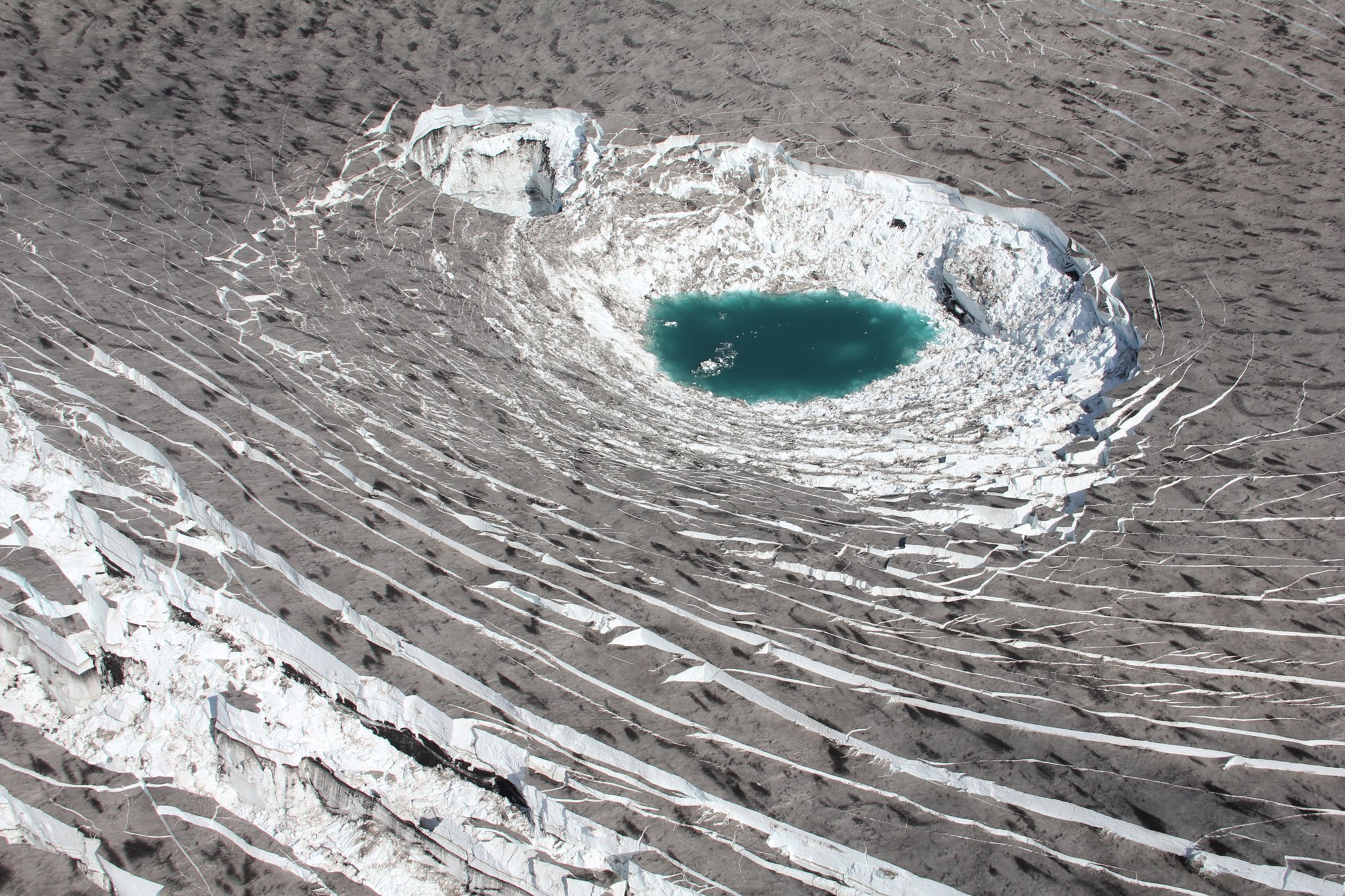
During the overflight of the glacier on July 18, 2011, geologists discovered another new basin in addition to the basin from which the glacier run had come, and noted that the glacier surface was generally sinking. Because of the numerous new crevasses, the southeastern Mýrdalsjökull should currently be avoided. At the same time, the series of earthquakes below Mýrdalsjökull continue.
In September 2011, the geologist Einar Kjartansson from the Icelandic Meteorological Office IMO defined the course of the glacier as the result of a small volcanic eruption of the Katla. This opinion does not seem to be shared by the Dean of the Volcanological Institute of the University of Iceland Magnús Tumi Guðmundsson, who stated in an interview with the same newspaper on September 7, 2011 that the Katla eruption could be due to typical and currently existing features such as accumulation of earthquakes and expansion is imminent.
Developments in 2014
At the beginning of July 2014 there was again increased activity under Mýrdalsjokull. On July 8th there was a - comparatively small - glacier run on the rivers Múlakvísl and Jökulsá . The cause has not yet been clarified, but volcanologists have not yet seen any signs of an imminent major eruption.
Because of the risk of further glacier runs and escaping volcanic gases - above all sulfur compounds - the Icelandic authorities issued a short-term travel warning for the area around Mýrdalsjökull and Sólheimajökull from July 9th .
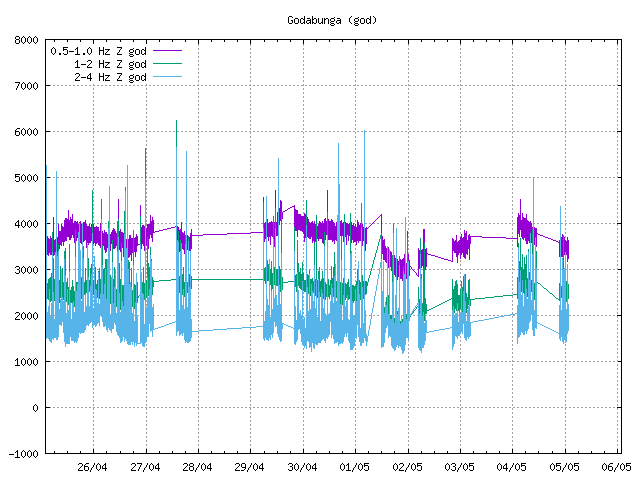
Increased seismic activity was registered under Mýrdalsjokull for a week, after which the situation calmed down again.
Typical sequence of a volcanic eruption of the Katla with glacier run

The location of the volcano under a glacier makes it difficult to observe small eruptions, some of which could go unnoticed as long as they only produced insignificant glacier runs .
Since the last major eruption took place in 1918, there has not yet been an opportunity to use scientific methods to analyze a major Katla eruption while it was taking place.
According to the annals, the larger Katla eruptions are usually heralded by a series of earthquakes, including one or more rather strong earthquakes. This happens about a day before the actual outbreak. This is presumably related to the melting of the ice cover, which is up to 750 m thick, but mostly at least 300–600 m thick, above the eruption points. This is followed by a strong explosive phase with eruption columns that can reach a height of at least 10–15 km. The tephra consists in most cases of dark mafic rock . Depending on its chemical composition, it can cause damage to human and animal health.
As last observed during the explosive eruption of Eyjafjallajökull in April 2010, frequent lightning bolts in the eruption column as well as thundering and cracking noises characterize this eruption phase.
After all, Mýrdalsjökull with the Katla in Iceland is particularly notorious for the glacier runs associated with larger eruptions.
A volcanic eruption under a glacier results in a glacier run because the heat of the magma melts large amounts of ice. The contact of the melt water with hot lava leads to enormous steam explosions, so-called phreatomagmatic explosions , in which the volcanic material is torn down to the smallest particles. In addition, enormous amounts of meltwater are created. When enough has accumulated, the mixture breaks through the ice barrier, the glacier floats on top of the mixture and the tidal wave breaks out from under it, as can be seen from the glacier runs from the Grímsvötn following the eruption in Gjálp in 1996.
The Katla glacier courses differ from those of other glacier volcanoes in that they do not last long, but transport a lot of liquid (mixture of water, mud, ice, etc.). At the same time, the steep gradient from the glacier to the sea means that the tidal waves move very quickly. They can tear icebergs 200 m long and 18 m high with them, but usually only last a few hours.
Of the 17 glacier runs recorded so far, 15 poured in an easterly direction over the Mýrdalssandur and only two in the south over the Sólheima or Skógasandur . Only one flood inundated the Markarfljót river plains to the west 1,600 years ago . The Tröllagjá gorge was created in the Emstrur (see Laugavegur ).
Shifting the beach line
Each time the volcano erupts, enormous amounts of volcanic ash and debris are transported into the sea. T. is advanced considerably. Despite constant erosion of the beach by ocean currents between the eruptions, the coastline in front of the island mountain Hjörleifshöfði has been shifted by approx. 5 km out into the sea since the beginning of the land grab from 870 AD .
Exploration and monitoring of the volcano
The volcano is currently the best-monitored in the country. Numerous earthquake stations measure earth movements. The water of the rivers surrounding it is regularly examined for its mineral content, gas content and electrical conductivity .
The geologists have also carried out numerous investigations into the location and shape of the glacier bedrock in order to determine the exact appearance of the caldera. Based on the calculations based on this and the knowledge that has now been accumulated about the functioning of the volcano, it is assumed that in the event of a future eruption, the majority of the flood will again fall on the Mýrdalssandur, with a ten percent probability that a flood will fall on the valley of the Markarfljót River , especially starting from the Entujökull side glacier and a twelve percent probability is attributable to a glacier run on the Sólheima and Skógasandur .:
See also
- Volcanoes in Iceland
- Iceland glaciers
- Geography of Iceland
- List of mountains and elevations in Iceland
literature
- Werner Schutzbach: Katla, the story of an Icelandic volcano. Reykjavík 2005
- Thor Thordason, Armann Hoskuldsson: Iceland. Classic Geology in Europe 3. Harpenden 2002, v. a. Pp. 103-106.
Web links
Photos and videos
- Image of one of the boilers in Mýrdalsjökull (photo taken by photographer and journalist Omar Ragnarsson on July 16, 2011)
- DV, close-up of a burglar boiler on Mýrdalsjökull
- Film for information about Katla outbreaks from Almannavarnir (Icelandic civil defense) (Icelandic with English subtitles)
- Video: Flight over Mýrdalsjökull with the burglar boilers and Eyjafjallajökull, July 2011
Scientific representations
- Katla in the Global Volcanism Program of the Smithsonian Institution (English)
- Univ. Iceland: Description of Katla (English)
- Bergrún A. Óladóttir, ea: Katla volcano, Iceland: magma composition, dynamics and eruption frequency as recorded by Holocene tephra layers , Bulletin of Volcanology, Vol. 70, no. 8, 475–493, doi : 10.1007 / s00445-007-0150-5 (English)
- E. Sturkell, ea: 2 Katla and Eyjafjallajökull Volcanoes, Developments in Quarternary Science , Vol. 13, 2010, 5–21 (On the Katla and Eyjafjallajökull volcanoes) (English), doi : 10.1016 / S1571-0866 (09) 01302- 5 .
- F. Albino et al. a .: Influence of surface load variations on eruption likelihood: application to two Icelandic subglacial volcanoes, Grímsvötn and Katla , Univ. Iceland 2010 (English), doi : 10.1111 / j.1365-246X.2010.04603.x .
- Haraldur Sigurðsson: Múlakvíslarhlaupið - eldgos í Kötlu eða jarðhiti? (Blog entry by geologist Haraldur Sigurðsson) from July 13, 2011 (Icelandic)
- Oddur Sigurðsson: Áhrif gjóskufalls á leysingu jökla. Veðurstofa Íslands, May 30, 2011 (Icelandic); Accessed July 19, 2011
Volcano monitoring on the Katla
- Off. Information for tourists about dangers on the Katla (German) (PDF file; 1.3 MB)
- Webcam of the television station RUV for monitoring the Katla
- Monitoring the Katlacaldera, Geolog. Institute, University of Iceland (English)
- Overview of earthquakes on the Katla, IMO
- Further data on Katla, bulge etc., IMO, Vedurstofan Íslands
Individual evidence
- ↑ Ásgeir Blöndal Magnússon: Íslensk Orðsifjabók, Reykjavík, 1989, p. 450 [etymological dictionary], own translation into Ger.
- ↑ Katla - Nordic Names Wiki - Name Origin, Meaning and Statistics (English) accessed on April 21, 2010
- ^ Willhardt, Sadler, Iceland. 2003, p. 342.
- ↑ Werner Schutzbach: Katla, the story of an Icelandic volcano, Reykjavík, 2005, p. 7
- ↑ Schutzbach, p. 11
- ↑ Katla . earthice.hi.is. Archived from the original on June 22, 2005. Retrieved July 18, 2011.
- ^ Ari Trausti Guðmundsson , Halldór Kjartansson: Land im Werden. 1996, p. 42
- ↑ a b c d Thor Thordarson, Armann Holskuldsson: Iceland. Classic Geology in Europe 3. Harpenden 2002, p. 103.
- ↑ Thor Thordarson, Armann Holskuldsson: Iceland. Classic Geology in Europe 3. Terra, Harpenden 2002, p. 106
- ↑ Katla (á ensku) . jardvis.hi.is. Archived from the original on May 23, 2006. Retrieved July 18, 2011.
- ↑ Ulf Büntgen u. a .: Multi-proxy dating of Iceland's major pre-settlement Katla eruption to 822–823 CE . In: Geology . 2017, doi : 10.1130 / G39269.1 .
- ↑ Michael McCormick, Paul Edward Dutton and Paul A. Mayewski: Volcanoes and the Climate Forcing of Carolingian Europe, ad 750-950 . In: Speculum . tape 82 , 2007, doi : 10.1017 / S0038713400011325 .
- ^ A b Thor Thordarson, Armann Hoskuldsson: Iceland. Classic Geology in Europe 3. Terra, Harpenden 2002, 109
- ↑ a b Clive Oppenheimer u. a .: The Eldgjá eruption: timing, long-range impacts and influence on the Christianization of Iceland . In: Climatic Change . March 2018, doi : 10.1007 / s10584-018-2171-9 (Open Access).
- ↑ Thor Thordarson, Armann Hoskuldsson: Iceland. Classic Geology in Europe 3. Terra, Harpenden 2002, 110
- ↑ Thor Thordarson, Armann Hoskuldsson: Iceland. Classic Geology in Europe 3. Terra, Harpenden 2002, 106
- ^ A b Thor Thordarson, Armann Hoskuldsson: Iceland. Classic Geology in Europe 3. Terra, Harpenden 2002, 105
- ↑ a b Katla Og Kötlugos Eftir Ara Trausta Guðmundsson . mbl.is. Retrieved July 18, 2011.
- ↑ Katla - Eruptive History . volcano.si.edu. Retrieved July 18, 2011.
- ↑ cf. W. Schutzbach: Katla , Reykjavík 2005, 104ff.
- ↑ cf. z. B. Múlakvíslarhlaupið -eldgos eða jarðhiti? Blog entry by geologist Haraldur Sigurðsson from July 13, 2011 (Icelandic) Accessed: July 17, 2011
- ↑ Thor Thordarson, Armann Holskuldsson: Iceland. Classic Geology in Europe 3. Harpenden 2002, p. 105 (own translation from English)
- ↑ Data from: Thor Thordarson, Armann Holskuldsson: Iceland. Classic Geology in Europe 3. Harpenden 2002, p. 105
- ^ W. Schutzbach: Katla . 2005, 165ff.
- ↑ a b Andrew J. Russell, Fiona S. Tweed, Matthew J. Roberts, Tim D. Harris, Magnús T. Gudmundsson, Óskar Knudsen, Philip M. Marren: An unusual jökulhlaup resulting from subglacial volcanism, Sólheimajökull, Iceland . In: Quaternary Science Reviews . 29, No. 11-12, June 2010, ISSN 0277-3791 , pp. 1363-1381. doi : 10.1016 / j.quascirev.2010.02.023 .
- ^ W. Schutzbach: Katla . 2005, 165ff.
- ↑ http://wayback.vefsafn.is/wayback/20050622000000/earthice.hi.is/page/iesmysurv Katla monitoring , Institute of Earth Sciences, Univ. of Iceland (English); Accessed July 20, 2011
- ↑ Katla −14 earthquakes in 48 hours! . iceagenow.com. Retrieved July 18, 2011: “Fourteen earthquakes have occurred below Iceland's Mýrdalsjökull glacier during the past 48 hours - one within the last 4 hours. Katla Volcano lies beneath the Mýrdalsjökull glacier. "
- ↑ Iceland's president says eruption is only 'small rehearsal' . In: BBC , April 20, 2010. Retrieved July 18, 2011.
- ↑ cf. z. B. Ari Trausti Guðmundsson: “Eyjafjallajökull gýs sjaldan en Katla often. Á sögulegum tíma Höfum við tvö dæmi þess að Katla rumskar um leið og eldgosi lýkur. Kannski verður þetta með svipuðum hætti núna en það er aldrei hægt að ráða í hegðun eldfjalla. Ástæðan fyrir þessu liggur ekki fyrir og hefur lítið forspárgildi. "(Own translation:" Eyjafjallajökull seldom breaks out, Katla, however, often. In historical times (ie since the 9th century, translator's note) we have two examples for Katla to move as soon as the eruption stops. Perhaps it will be the same again, but it is never possible to interpret the behavior of volcanoes. The reason for this is unknown and has therefore little validity with regard to predictions. ”) (Online) Accessed: January 6, 2011
- ↑ Veðurstofan Íslands, monthly overview of the earthquake situation in May 2011. Accessed on July 11, 2011 (Icelandic).
- ↑ Veðurstofan Íslands, weekly overview of the earthquake situation from July 4, 2011 to July 10, 2011. Accessed on July 11, 2011 .
- ↑ cf. also current location: Veðurstofan Íslands to the earthquake situation at Mýrdalsjökull. Retrieved July 11, 2011 .
- ↑ cf. Website of the Volcanological Institute of the University of Iceland. Retrieved July 11, 2011 (Icelandic).
- ↑ a b KATLA Southern Iceland 63.63 ° N, 19.05 ° W; summit elev. 1512 m . volcano.si.edu. Retrieved July 18, 2011.
- ↑ Gos hugsanlega hafið. Retrieved July 10, 2011 (Icelandic).
- ^ Glacier-outburst flood from Mýrdalsjökull , IMO, July 11, 2011 (English); Accessed September 6, 2011
- ↑ cf. Vedurstofan Íslands. Retrieved July 11, 2011 .
- ↑ website of the Icelandic television channel RUV on 15 July 2011 (Icelandic); Accessed July 15, 2011
- ↑ Brúin yfir Múlakvísl opnuð á morgun (15-07-11) ruv.is. Archived from the original on July 30, 2011. Retrieved July 18, 2011.
- ↑ http://dagskra.ruv.is/sjonvarpid/4547409/2011/07/19/ Fréttir , RÚV, July 19, 2011 (evening news of the state television station RÚV, Icelandic); Accessed July 19, 2011
- ↑ cf. also: http://wayback.vefsafn.is/wayback/20110727034949/www.ruv.is/frett/thrystingur-fellur-i-sigkotlunum Þrýstingur fellur í sigkötlunum , Fréttir, RÚV, July 19, 2011 (Icelandic); Accessed July 20, 2011
- ↑ http://en.vedur.is/earthquakes-and-volcanism/earthquakes/myrdalsjokull/ Icelandic Met Office (English); Accessed July 19, 2011
- ↑ http://www.mbl.is/frettir/innlent/2011/09/26/litid_eldgos_i_kotlu_i_sumar/ Lítið eldgos í Kötlu í sumar , MBL, September 26, 2011; Accessed October 2, 2011
- ↑ http://www.mbl.is/frettir/innlent/2011/09/07/visbendingar_um_ad_katla_se_ad_bua_sig_undir_eldgos/ Vísbendingar um að Katla sé að búa sig undir eldgos , MBL, September 7, 2011; Accessed October 2, 2011
- ↑ http://www.ruv.is/frett/ekki-gos-en-varasamt-ad-stoppa-vid-ana
- ↑ http://grapevine.is/news/2014/07/10/seriously-stay-away-from-katla/
- ↑ http://www.vedur.is/skjalftar-og-eldgos/jardskjalftar/myrdalsjokull/
- ↑ Information for tourists about the dangers on the Katla ( memento of the original from December 18, 2015 in the Internet Archive ) Info: The archive link was automatically inserted and not yet checked. Please check the original and archive link according to the instructions and then remove this notice. (PDF; 1.4 MB)
- ↑ cf. also: Jónas Elíasson et al .: Probabilistic model for eruptions and related flood events in the Katla caldera, Iceland . In: Computional Geosciences (2006) 10, pp. 179-200, accessed: November 28, 2010