
Icelandic highlands
The Icelandic Highlands ( Icelandic Hálendið ) comprise most of the interior of Iceland . According to the Icelandic Konversationslexikon ( Icelandic Íslenska alfræðiorðabókin ), which defines highlands as those parts of the country that are more than 200 meters above sea level, the proportion would be about 75% of the total area of Iceland. About 40% of the country's area is higher than 400 to 500 meters.


Landscapes and vegetation
The highlands are very dry and exposed to strong winds. It contains various forms of landscape such as moraine landscapes (isl .: jökulgarðar = glacier gardens), stone and sand deserts, volcanoes of all kinds, lava fields , freshwater lakes, glaciers and rivers often dug into deep gorges. Wherever water can spread, there are swampy “oases”. In more protected locations with enough water, all kinds of bog and highland plants grow, such as the arctic willowherb or the stem-less celibate . Otherwise the highlands are essentially plantless. In these parts of the country it is an edaphic inland desert that is mostly gray-black in color due to the volcanic rock material of the island , in which precipitation falls, but it usually seeps into the ground without a trace.
Property rights
Most of the land belongs to farmers and communities who use parts of it as high pastures (isl. Afréttir ). This can be seen from the fences that are visible to the surprise of visitors in the wilderness, for example on the Kaldidalur not far from Þórisjökull . They are supposed to prevent the sheep from migrating to the other area of the community and thus prevent the spread of diseases.
The state also claims parts of it, for example in the Vatnajökull National Park. In some cases, there are legal disputes regarding property, for example in the case of Þeistareykir in the north of Iceland, where the state wants to use geothermal energy .
Distinctions between terms
Neck
It corresponds to the German term Höhenzug (similar to the mountain neck in German) and also belongs to the highlands. A typical háls , for example, lies between Reykholtsdalur in western Iceland and the upper valley of the Hvítá . After that, the area on the ridge south of the Hvítá and at its foot is also referred to with the old district name: Hálsasveit in today's municipality of Borgarbyggð .
Heiði
This means a plateau that is generally not inhabited (anymore, see Jökuldalsheiði ). A typical example would be the Mosfellsheiði between Reykjavík and Þingvellir . Based on this, the term is traditionally used mostly for mountain passes that cross the plateaus, e.g. B. Holtavörðuheiði or Hellisheiði eystri , which lies between Egilsstaðir and Vopnafjörður .
(Mið-) Hálendið
This is the centrally located highlands over 500 m altitude without the otherwise comparable landscapes of the large peninsulas, such as Snæfellsnes and Westfjords . With one exception, the lonely farm Möðrudalur in Möðrudalsöræfi , it is uninhabited. This term mainly plays a role in meteorological information.
The highlands also include the numerous glaciers such as most of the Vatnajökull , Langjökull or Hofsjökull . There is also some vegetation on the glacier rivers . On the other hand, certain rivers in the highlands can be quite dangerous because of the recurring glacier courses and tidal waves that are triggered by volcanic activity.
Some extremely attractive areas with volcanic activity are in the highlands such as Landmannalaugar , Hveravellir , the area around Askja , around Snæfell , near Herðubreið or Kerlingarfjöll .
Navigability
The highlands can only be crossed by off-road vehicles during the Icelandic summer (June - August). Otherwise the highland slopes are closed.
The most famous highland slopes are the Kaldidalur , Kjölur and Sprengisandur routes.
The opening times are determined by the Icelandic road authority Vegagerðin u. a. announced on the Internet, whereby the red color always means a closed slope (= Isl. "ófært"). The site is also available in an English language version.
General rules of conduct for driving in the highlands
For motor vehicle traffic in the highlands, the general rule is that the slopes must not be left. The barren vegetation only recovers from destruction, such as tire tracks, after many years.
On most routes there are only sometimes, if ever, bridges, so that rivers have to be crossed in fords . It is advisable to pay particular attention to the time of day and the weather conditions, especially in the highlands. For example, the hut keepers have information about the weather ( e.g. in Nýidalur or in Hveravellir ). When the weather is warm in summer, the rivers generally carry more water in the evening because the snow and ice on the glaciers melt, for example in the Þórsmörk . In addition, the weather conditions in the highlands can change quickly, snowfall in July and August is not uncommon.
On less traveled highland roads, such as in North Iceland into Kverkfjöll or on Gæsavatnaleið as well as on Fjallabaksleið nyrðri in South Iceland as well as on the glaciers, you should never go alone, but rather drive with other jeeps in a group. This makes it easier to drive across fords and increases safety.
It should be noted that there is no telephone connection in large parts of the highlands. It is therefore a safety factor to always check in and out with hut keepers and tell them your destination. There are also orange-colored emergency huts on all highland roads, equipped with radios, blankets and food supplies.
- Driving in the highlands
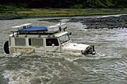
Ford in the Þórsmörk

Notice board at a ford

On the Lyngdalsheiði between Þingvellir and Laugarvatn in winter
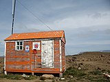
Emergency hut on the Kaldidalur route


Energy generation
In the north-west of the highlands, the Blöndulón reservoir was built in the 1980s . There are also several reservoirs near the Hekla, such as the Sigöldulón and north of the Vatnajökull around the Kárahnjúkar mountain, the Hálslón reservoir .
In addition, the Hellisheiði power station , Nesjavellir , Bjarnaflag and Krafla geothermal power plants are located in the highlands.
attachment
supporting documents
- ↑ cf. also HUSchmid: Dictionary Icelandic-German. Buske, Hamburg 2001, 104: Schmid translates háls with neck; Hill .
- ↑ cf. http://www.borgarbyggd.is/sveitarfelagid/ Off. Borgarbyggð Municipality website (Icelandic); Accessed June 30, 2011
- ↑ cf. z. B. Evidence for both uses: Icelandic Road Watch's webcam page, Holtavörðuheiði (Icelandic ); Accessed June 30, 2011
- ↑ cf. also the general information of the Icelandic Road Transport Authority on the road system in Iceland: http://wayback.vefsafn.is/wayback/20090814133322/www.vegagerdin.is/vefur2.nsf/Files/Vegakerfid_english/$file/ATTRJY5V.pdf (PDF file ) (English); Accessed June 30, 2011
- ↑ Road conditions in Iceland ( English ) Vegagerðin. Accessed January 30, 2018.