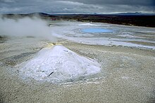
Hveravellir
Hveravellir ( Icelandic hver "hot spring"; vellir "fields") describes both a central volcano under the Langjökull glacier in western Iceland and the associated geothermal area .
The Hveravellir volcanic system
This is one of the two clearly known volcanic systems linked to the Langjökull glacier shield .
It is located at the northwest end of Iceland's active volcanic zone, which extends northeast from the Reykjanes Peninsula. The volcanic zone makes a bend to the east towards Kerlingarfjöll and Hofsjökull .
The central volcano is located in the northeast half of the elongated glacier shield of Langjökull. A caldera was discovered under the ice .
The associated volcanic fissure system in the northeast of Langjökull extends to the southwest far below the large glacier shield and into the Þjófadalir . Smaller craters in the west of the glacier, e.g. B. those from which the lavas of the Hallmundarhraun poured, are still added to him.
Kjalhraun lava field
The shield volcano in the Kjalhraun lava field produced around 11 km³ of lavas when it last erupted around 7,800 years ago. Several other smaller shield volcanoes belonging to the same system also produced post-glacial lava flows that surround Langjökull to the north, west and east.
Hallmundarhraun lava field
The Hallmundarhraun lava field in the west of Langjökull also flowed out of a row of craters on the west side of Langjökull in the 9th century, which is assigned to the same system. It is located on the Arnarvatnsheiði plateau .
The associated high temperature area of Hveravellir
It should not be confused with the high-temperature area of the same name in Reykjahverfi in the Þingeyrarsysla district in northern Iceland.
location
The high temperature area is about 90 km on the Kjölur overland slope from Gullfoss waterfall to Hveravellir. To the north, the distance to Blönduós is approx. 110 km. At the same time, Hveravellir is roughly halfway between Reykjavík and Akureyri , about 200 km from both places.
Hveravellir is located in the Kjölur highlands in the Icelandic highlands . It is located at about 640 m altitude between the glaciers Langjökull and Hofsjökull and about in the middle of Kjalvegur (F35).
The information on many websites and on maps that there is a petrol station in Hveravellir is out of date. The petrol station has not existed for many years, so a sufficient fuel supply is essential for a trip to Hveravellir or beyond (as of September 2015).
description
There are many typical features of high temperature areas in Hveravellir. There are hot water springs here, such as the Bláhver ("blue spring") surrounded by sinter terraces , fumaroles and the hissing solfatare Öskurhöll ("roaring hill"). Bræðrahver and Eyvinderhver are small spring springs.
Quite unusual for Iceland are the sintered terraces formed by volcanism.
The geothermal area has been a nature reserve since 1960.
Sport and recreation
A hut belonging to the Ferðafélag Íslands hiking club has been in the high-temperature area since 1938, and a newer house has been there since 1980.
In addition, the area offers a thermal bath with a natural rock tub of approx. 25 square meters and an inlet temperature of over 80 degrees, which is mixed down to well below 40 degrees, as well as several hiking trails.
history
According to tradition, Fjalla-Eyvindur , an outlawed Icelander convicted of theft, lived with his wife at Hveravellir in the 18th century . A cave-like hut, Eyvindar-Kofi, can still be visited. It is said that he prepared his meal in the Eyvindarhver spring . In addition, the remains of a sheep pen Eyvindar-Rétt are named after him.
A weather station of the Meteorological Office has been in Hveravellir since 1965.
See also
Individual evidence
- ↑ to: Hveravellir in the Global Volcanism Program of the Smithsonian Institution (English) Access: April 10, 2010.
- ↑ a b c Íslandshandbókin. 2. bindi. Örn & Örlygur, Reykjavík 1989, OCLC 165274883 , p. 880.
- ↑ Íslandshandbókin. 2. bindi. P. 881.
literature
- Jens Willhardt, Christine Sadler: Iceland . 3rd updated and revised edition. Michael Müller, Erlangen 2003, ISBN 3-89953-115-9 , p. 623f.
- Rainer Strzolka, Susanne Engelmann-Strzolka: Hveravellir. Verlag für Ethnologie, Hannover 2011, ISBN 978-3-86421-975-7 .
Web links
- Hveravellir in the Global Volcanism Program of the Smithsonian Institution (English)
Coordinates: 64 ° 51 ′ 55.1 ″ N , 19 ° 33 ′ 24 ″ W.


