
Gullfoss
| Gullfoss | ||
|---|---|---|
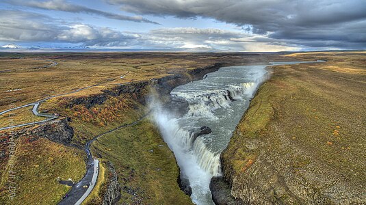
 The Gullfoss with first (top left) and second (bottom) drop step |
||
| Coordinates | 64 ° 19 '33.6 " N , 20 ° 7' 15.6" W | |
|
||
| place | Southurland , Iceland | |
| height | 32 m | |
| width | 229 m | |
| Number of fall levels | 2 | |
| flow | Hvítá | |

The Gullfoss [ 'kʏtl̥ˌfɔsː ] ( isl. Gull = "gold", foss = "waterfall") is a waterfall of the river Hvítá in Haukadalur in southern Iceland .
The river Hvítá forms the municipal boundary between Hrunamannahreppur and Bláskógabyggð .
Gullni hringurinn: Golden ring
With Þingvellir and the neighboring geysers, the waterfall belongs to the so-called Gullni hringurinn ( Golden Circle , literally: "Golden Ring" or "Golden Tour") of the most famous sights in Iceland.
Most important dates
Its average water flow is about 109 m³ / s, in summer about 130 m³ / s. The largest discharge measured so far was 2000 m³ / s.
The waterfall consists of two steps, the first 11 m and the second 21 m high. These two cascades are roughly at right angles to each other.
From the second stage, the water plunges into a gorge that is 2.5 km long from the waterfall to the widening to the valley and reaches a depth of 70 meters. The waters of the Hvítá and not least the occasional glacier runs have cut this gorge by an average of 25 cm per year since the Ice Age 10,000 years ago.
Two glacier runs in the 20th century are known, 1930 and 1948. In these, the gorge was completely filled with water, so that the lower waterfall level temporarily disappeared underneath.
Sigríður Tómasdóttir and the rescue of Gullfoss
The fact that this waterfall still exists is thanks to the efforts of Sigríður Tómasdóttir from the nearby Brattholt farm, who opposed the construction of an electricity station at the waterfall around 1920 . An English company had leased the waterfall to a dam to build and electricity to produce. After years of litigation with the help of the lawyer and later President of Iceland Sveinn Björnsson , when all efforts seemed hopeless and Sigríður threatened to commit suicide in the floods, the contract could finally be terminated due to a lease paid too late and eventually returned to the Icelandic state . A stone notice board near the waterfall reminds of this.
A project from 1977 that should have supplied 2444 gigawatt hours of electricity per year and diverted three quarters of the amount of water was also rejected.
The waterfall still belongs to the Icelandic state and has been a nature reserve since 1979 .
traffic
Gullfoss can be reached via road 35, Biskupstungnabraut ![]() , which continues north as Kjalvegur from here
, which continues north as Kjalvegur from here ![]() .
.
See also

Second step (left) and gorge

Monument to Sigríður Tómasdóttir at the waterfall

Gullfoss canyon in winter; opposite the second stage, massive ice walls form from water droplets

The Gullfoss seen from the side


Web links
Individual evidence
- ↑ Íslandshandbókin. Náttúra, saga og sérkenni. 2. bindi. Edited by T. Einarsson, H. Magnússon. Örn og Örlygur, Reykjavík 1989, pp. 792f.
- ↑ Archive link ( Memento of the original from October 14, 2011 in the Internet Archive ) Info: The archive link was inserted automatically and not yet checked. Please check the original and archive link according to the instructions and then remove this notice. nat.is; Accessed September 4, 2012
- ↑ Friðlýst svæði: Suðurland, Gullfoss, Umhverdisstofnun; Accessed September 4, 2012