Kjalvegur
| Main road 35 in the highlands of Iceland |
|||||||||||||||||||||||||||||||||||||||||||||||||||||||||||||
| Kjalvegur | |||||||||||||||||||||||||||||||||||||||||||||||||||||||||||||

|
|||||||||||||||||||||||||||||||||||||||||||||||||||||||||||||
| map | |||||||||||||||||||||||||||||||||||||||||||||||||||||||||||||
| Basic data | |||||||||||||||||||||||||||||||||||||||||||||||||||||||||||||
| Operator: | Vegagerðin | ||||||||||||||||||||||||||||||||||||||||||||||||||||||||||||
| Start of the street: |
Sponge cake ( 64 ° 19 ′ N , 20 ° 8 ′ W ) |
||||||||||||||||||||||||||||||||||||||||||||||||||||||||||||
| End of street: | Svínvetningabraut ( 65 ° 30 ′ N , 19 ° 53 ′ W ) |
||||||||||||||||||||||||||||||||||||||||||||||||||||||||||||
| Overall length: | 167.67 km | ||||||||||||||||||||||||||||||||||||||||||||||||||||||||||||
| Development condition: | not paved | ||||||||||||||||||||||||||||||||||||||||||||||||||||||||||||
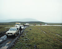
| Past: On Kjalvegur 1985 still without bridges | |||||||||||||||||||||||||||||||||||||||||||||||||||||||||||||
|
Course of the road
|
|||||||||||||||||||||||||||||||||||||||||||||||||||||||||||||
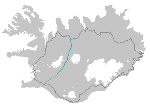
The Kjalvegur is a main road in the highlands of Iceland that connects the southwest with the northwest .
The highland path is also called Kjölur after a valley it crosses. At 168 km it is the second longest and middle one of the highland passages of Iceland in a north-south direction. It has had the same number as the biscuit bride since 2001 ![]() and its continuation north. Before 1995 it was the F37 , which
and its continuation north. Before 1995 it was the F37 , which ![]() had the Kaldidalsvegur , which then
had the Kaldidalsvegur , which then ![]() became the. As early as the mid-1990s, the Kjalvegur was designed in such a way that you no longer have to ford waters. As for all Fjallvegir , these roads are closed in winter. It
became the. As early as the mid-1990s, the Kjalvegur was designed in such a way that you no longer have to ford waters. As for all Fjallvegir , these roads are closed in winter. It ![]() is divided into two sections and was released again between June 2nd and July 1st in recent years. The southern section to Hveravellir is often the last.
is divided into two sections and was released again between June 2nd and July 1st in recent years. The southern section to Hveravellir is often the last.

course
The Kjalvegur begins next to the Gullfoss waterfall as a continuation of the biscuit bride ![]() and bears the same number. It is even paved as far as the bridge over the Sandá. The river arises from the Sandvatn on the southern edge of Langjökull . The bridge over the Hvítá is 73 m long and was built in 1973. Further north, Kerlingarfjallavegur
and bears the same number. It is even paved as far as the bridge over the Sandá. The river arises from the Sandvatn on the southern edge of Langjökull . The bridge over the Hvítá is 73 m long and was built in 1973. Further north, Kerlingarfjallavegur ![]() (10 km) branches off to the east to Kerlingarfjöll . Here the road crosses the Kjölur valley on the edge of the Kjalhraun , between Hofsjökull in the east and Langjökull in the west. 28 km behind the Kerlingarfjallavegur the Þjófadalavegur leads
(10 km) branches off to the east to Kerlingarfjöll . Here the road crosses the Kjölur valley on the edge of the Kjalhraun , between Hofsjökull in the east and Langjökull in the west. 28 km behind the Kerlingarfjallavegur the Þjófadalavegur leads ![]() into the thermal area of Hveravellir .
into the thermal area of Hveravellir .
Before the Seyðisá river, Vesturheiðarvegur turns ![]() east and reaches the ring road after 54 . There is now a bridge over the Seyðisá. The ford at the confluence with the Beljandi used to be the biggest obstacle on the road. Further north there are five more bodies of water before reaching the Blöndulón reservoir. Its dam and the power station were built between 1984 and 1991 and the road thus runs further west. Then the Mælifellsdalsvegur
east and reaches the ring road after 54 . There is now a bridge over the Seyðisá. The ford at the confluence with the Beljandi used to be the biggest obstacle on the road. Further north there are five more bodies of water before reaching the Blöndulón reservoir. Its dam and the power station were built between 1984 and 1991 and the road thus runs further west. Then the Mælifellsdalsvegur ![]() , also a highland road, branches off to the east and reaches
, also a highland road, branches off to the east and reaches ![]() the ring road via Skagafjarðarvegur after 87 km. Before it ends, the Kjalvegur passes the above-ground part of the Blanda power station before it
the ring road via Skagafjarðarvegur after 87 km. Before it ends, the Kjalvegur passes the above-ground part of the Blanda power station before it ![]() ends at Svínvetningabraut . This reaches the ring road after 5 km to the east or after 27 km to the west near Blönduós .
ends at Svínvetningabraut . This reaches the ring road after 5 km to the east or after 27 km to the west near Blönduós .
See also
Individual evidence
- ↑ Vegaskrá 2018 - kaflaskipt. Retrieved July 31, 2019 (Icelandic).
- ↑ Bundið slitlag á þjóðvegum 2019. Retrieved July 28, 2020 (Icelandic).
- ↑ Opnun_fjallvega_is_2019. Retrieved August 1, 2019 (Icelandic).
- ↑ Brúaskrá bryr á þjóðvegum. Accessed July 31, 2019 (isl.).


