
Kaldidalur

Coordinates: 64 ° 34 ′ 0 ″ N , 20 ° 46 ′ 0 ″ W.

The Kaldidalur ( Icelandic cold valley ) is a valley in the western Icelandic highlands . It is located in the municipality of Borgarbyggð .
location
It is located between the Ok volcano and the Þórisjökull glacier . Its highest point is at 727 m. The Prestahnúkur volcanic system is to the east of the valley.
Highland slope
The Kaldadalsvegur ![]() is a main road in the highlands in the west of Iceland , which runs through this valley.
is a main road in the highlands in the west of Iceland , which runs through this valley.
Photos

Emergency hut

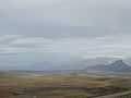
desert landscape
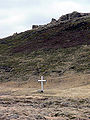
Biskupsbrekka
Kaldidalur slope on Þorisjökull


