Möðrudalur
Möðrudalur is a remote farm in northeast Iceland .
Geography and description
It lies roughly in the middle between Egilsstaðir in the east and Mývatn in the west. The farm with its meadows is surrounded by the desert area Möðrudalsöræfi, which is named after it .
At 469 m, it is the highest farm in the country that is still inhabited and cultivated today. In the main season (May to September) there is an information and catering service for visitors. Nearby are the Herðubreið mountain , the Askja volcano and the Kverkfjöll massif
history
The farm has been inhabited since Iceland was settled . Sheep is farmed on it.
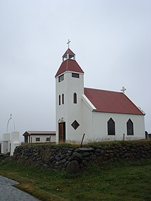
The small church was built by the farmer Jón A. Stefánsson, who died almost 100 years old in 1995, in memory of his wife in 1949. He also painted the altarpiece in the church by hand.
Until 2000 the farm was located directly on the Hringvegur . In the meantime, the part of road no. 1 has become Möðrudalsleið (no. 901) (8 km from Hringvegur) and the Hringvegur continues further north.
Web links
Coordinates: 65 ° 22 ′ 30 ″ N , 15 ° 53 ′ 0 ″ W.


