Dyrholaey
| Dyrholaey | ||
 View of Dyrholaey |
||
| Geographical location | ||
|
|
||
| Coordinates | 63 ° 23 '59 " N , 19 ° 7' 35" W | |
| Waters 1 | Atlantic Ocean | |
 Dyrholaey lighthouse |
||
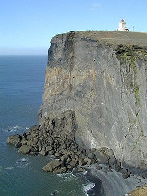
Dyrhólaey [ 'tɪːrˌhouˑlaˌeiˑ ], ( Isl. "Doorhole Island") is a 115 m high peninsula in the south of Iceland , about 6 km west of Vík í Mýrdal .
Volcanic origin
The cape, which slopes steeply towards the sea, was formed as an island 80,000 years ago during a submarine volcanic eruption . Even today one can notice a slight smell of sulfur compounds rising at the summit .
Worth seeing
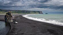
From above you have an excellent view of the sea and Mýrdalsjökull . To the east you can see the Reynisdrangar , the black rock needles in front of Vík, to the west you have a wide view along the south coast in good weather conditions.
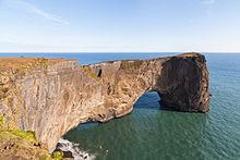
The tip of the cape forms a rock gate through which boats can pass and which gave it its name. The lighthouse from 1927 is also worth seeing. The first lighthouse from 1910 no longer exists.
Bird paradise
Dyrholaey is known for its abundance of birds. In summer it nests here next to terns and the like. a. also a large colony of puffins .
Access
The peninsula can be reached via road 218. The access to the plateau is possible via an unpaved, sometimes very impassable and steep slope.
Others
Contrary to popular belief, Dyrholaey is not the southernmost point of the main Icelandic island; this is rather 20 km further east near Kötlutangi.
See also
Web links
- Information (English)
- Cape Dyrhólaey (German)
Individual evidence
- ↑ Cape Dyrhólaey (German) ( Memento from July 27, 2011 in the Internet Archive ), accessed on May 12, 2017


