Geography of asia
This article deals with the geography of Asia .
Asia is the largest continent on earth. With an area of around 44.614 million square kilometers (excluding Russia 31.7 million square kilometers), it comprises around a third of the total land mass. Together with Europe , Asia is also seen as part of the greater continent of Eurasia .
The continental landmass lies entirely in the eastern hemisphere and north of the equator with the exception of the Chukchi Peninsula in eastern Siberia , which lies east of the date line, and the southeasternmost islands in the Malay Archipelago , which are located in the southern hemisphere of the earth.
expansion
Asia is bordered by the Arctic Ocean to the north, the Pacific Ocean to the east and the Indian Ocean to the south .
In the west, Asia has no clear geographical or geological boundary with Europe . The most common definition of the border with Europe from north to south: Ural Mountains , Ural River , Caspian Sea or Manytn lowlands , Caucasus , southern coast of the Black Sea as well as the Bosphorus , Marmara Sea and Dardanelles . From the Barents Sea in the north to the Black Sea in the south, this border is around 2700 km long.
With Africa Asia north of the Red Sea on the peninsula Sinai (Isthmus of Suez , 145 km wide) connected.
In the northeast, the mainland masses of Asia and North America are a little more than 80 km apart on the Bering Strait .
In the southeast the Malay Archipelago forms the connection to Australia .
The coastline of Asia is around 82,300 km, of which the Arctic Ocean accounts for 15,900 km, the Pacific Ocean for 27,300 km, the Indian Ocean for 33,600 km, and the Mediterranean and Black Sea together around 5500 km.
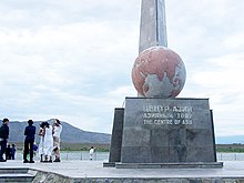
- According to calculations by the British geographer Douglas Carruthers from the early 20th century, the geographical center of Asia is near Kysyl in the autonomous Russian republic of Tuva in southern Siberia at the confluence of the large and small Yenisei .
- The northernmost point of the land mass is Cape Chelyuskin (77 ° 40 ′ north latitude) on the Taimyr Peninsula in Siberia .
- The southernmost point of the land mass is the state of Johor at the tip of the Malay Peninsula , the southeastern islands in the Malay Archipelago are even in the southern hemisphere.
- The westernmost point is Cape Baba in Asia Minor (26 ° 4 ′ east longitude).
- The easternmost point is on Cape Deschnjow (169 ° 44 ′ western longitude) on the Chukchi Peninsula in eastern Siberia.
Numerous larger islands and peninsulas are in front of the huge land mass .
- In the western part: Asia Minor ( Anatolia ) is the part of the Eurasian plate .
- In the south-west the Arabian Peninsula between the Red Sea and the Persian Gulf is geologically part of the Arabian Plate .
- India between the Persian Gulf and the Bay of Bengal , with the offshore island of Sri Lanka , is geologically part of the Indo-Australian Plate .
- In the southeast: Rear India with Indochina , Malaysia and Indonesia between the Bay of Bengal and the China Sea .
- On the east coast of Asia there are several south-facing peninsulas with offshore rows of islands: the Korean Peninsula , Kamchatka with the Kuriles , Sakhalin and the islands of Japan ( Hokkaidō , Honshū , Shikoku and Kyūshū ) and the Philippines .
- In the north, the Siberian coast, next to the Taimyr and Yamal peninsula , is characterized by the mouths of powerful rivers .
structure
The following subdivision of Asia into regions is used, among others, by the UN statistical agency UNSD :
- North Asia , not categorized by the UN
- Central Asia , UN regional code 143
- Middle East (West Asia), UN region code 145
- South Asia , UN region code 034
- East Asia , UN region code 030
- Southeast Asia , UN region code 035
In some publications, these limits are varied depending on the objective, subject, and background for which a split is used. Afghanistan was previously assigned to Central Asia, now to South Asia. There are also alternative or additional subdivisions, for example for Northeast Asia .
Rivers
Rivers that flow into the polar sea
The main rivers in Siberia run south to north into the Arctic Ocean. This made the development of Siberia difficult, since no west-east connection on the water is possible and the rivers are only navigable in summer. Nevertheless, the rivers are of great economic importance for supplying the areas north of the Trans-Siberian Railway. From west to east are the main rivers of Siberia: Ob , Yenisei , Lena and Kolyma .
The Ob is created by the union of the two rivers Bija and Katun in the South Siberian Mountains near the city of Biysk . The 3650 km long river flows in the West Siberian lowlands along the Urals. His mouth area, the Gulf of Ob , is a 1000 km long and up to 60 km wide estuary .
The sources of the Yenisei are in the Sajan Mountains in Tuva . The Big Yenisei (605 km long) and the Small Yenisei (680 km long) unite on the eastern edge of the city of Kyzyl to form the Yenisei. Then the Yenisei flows past the major cities of Abakan , Krasnoyarsk , joins the outflow of Lake Baikal , the Angara, and flows past the important port of Dudinka into the Kara Sea . The river has a length of 4092 km, a catchment area of 2,554,482 km² and carries around 19,600 m³ of water per second at the mouth, making it the most water-rich river in Siberia.
The Lena is one with a length of over 4400 km to the longest rivers in the world. The source of the river is only a few kilometers away from Lake Baikal , but thousands of kilometers from the Yenisei the river flows into the Laptev Sea . The catchment area of the Lena is 2,460,000 km² and leads to an amount of water of around 16,440 m³ per second (annual average 1994) at the mouth.
The last of the four big rivers is the Kolyma with a length of 2513 km and a catchment area of 526,000 km² and leads to a water volume of about 2728 m³ of water per second (annual average 1994) at the mouth. In the Kolyma Mountains and the bank of the Kolyma there, gold was mined until 1987. The workers were mostly criminals and prisoners of the Second World War.
Rivers that flow into the Pacific
The Amur is a 2,824 km long river in China and Russia that flows into the northern Pacific. The river is created around 65 km west of Mohe by the confluence of the Argun and the Schilka . The Amur is the border river between Russia and China.
The Yellow River , called Huang He (old German spelling Hoangho) in Chinese , is a river in the north of the People's Republic of China and has a length of 5464 km. This makes it China's second longest river. Its catchment area is 945,065 km². The source of the Yellow River is in the highlands of Tibet , about 200 km north halfway between Lhasa and Xining as the crow flies .
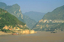
The Yangtze River , with a length of 6380 km, the longest river in Asia and after the Nile and the Amazon 's third-longest river in the world. 2800 km can be traveled by ships. The Yangtze River has a catchment area of 1,722,155 km² and carries around 31,900 m³ of water per second at the mouth. The source of the river is at 5405 m in the Tibetan Tangula Shan and its estuary near the city of Shanghai . On its way it passes numerous gorges and large cities. The "Three Gorges" with the long controversial Three Gorges Dam are the most famous of these. The main cities are Panzhihua , Yibin , Luzhou , Chongqing , Yichang , Jiangling , Shishou , Yueyang , Xianning , Wuhan , Ezhou , Huangshi , Jiujiang , Anqing , Tongling , Wuhu , Ma'anshan , Nanjing , Yangzhou , Zhenjiang and Nantong .
The Mekong is a river in Southeast Asia. Neither its source nor its length has yet been precisely determined. The information on its length varies from 4350 km to 4909 km. A unique natural phenomenon can be observed at Lake Tonle Sap every June. Due to the monsoon rains and the meltwater from the Himalayas, the Mekong has up to four times more water in June than in the dry months. This forces the water of the Mekong into the Tonle Sap River , which changes the direction of flow. The masses of water push back into the Tonle Sap basin and fill the lake. The Tonle Sap lake, together with the Tonle Sap, Mekong and Bassac rivers, forms a unique ecosystem that not only enables the biodiversity (around 300 species of fish, birds, ...) in the water and in the surrounding area, but also crucial for the development of those living in this area People and their Khmer culture was with the well-known temple complex of Angkor .
Rivers that flow into the Indian Ocean
The 2092 km long Ayeyarwady (Irawadi) is a river or stream in Southeast Asia. It rises in the extreme southeast of Tibet and flows 150 to 180 km southwest of Rangoon , a city in Myanmar , in an approx. 40,000 km² large estuary, which is mainly used as a rice-growing area and is pushed out into the Andaman Sea up to 60 m per year by the sediment deposits .
The river Ganges has a length of 2511 km. It flows through India and Bangladesh . After flowing through a huge estuary delta, like the 2998 km long Brahmaputra, it flows into the Bay of Bengal and thus into the Indian Ocean. It rises in the southwest of the Himalayan mountains and is revered as a sacred river by the Hindus .
At 3,180 km, the Indus is the longest river on the Indian subcontinent and the most important river in Pakistan. It originates in Tibet and flows into the Arabian Sea. The name for the country India was derived from the name of this river.
The area around the rivers Euphrates and Tigris in southeast Anatolia ( Turkey ), Syria and Iraq is called Mesopotamia or Mesopotamia called. The Euphrates has its source in the Armenian highlands in eastern Turkey, flows through Syria and Iraq in a south-easterly direction and merges there with the Tigris to form the Shatt al-Arab , which flows into the Persian Gulf . The Euphrates is the largest river in the Middle East and has a length of 2736 km, the Tigris has a length of 1899 km.
Lakes
Lakes without drainage
The Aral Sea is an outflowless salt lake , half of which lies in Kazakhstan and half in Uzbekistan. It is located in Central Asia in the middle of large deserts and steppes. The Aral Sea was once the fourth largest lake in the world with around 66,900 km². For several decades, however, only little water has reached the lake from the roof of the world via the rivers Amudarja (Uzbek: Amudaryo) and Syr-Darja , as it is diverted to turn the deserts into fields.
The Lake Balkhash , which means in German, "Marsh Lake" is an endorheic lake in the arid steppes of eastern Kazakhstan is (Asia). The lake, which is up to 18,428 km² in size, is located in a basin between the Kazakh threshold and the Seven Streams.
The Dead Sea forms an approximately 600 km² large, drainless salt lake that lies in a depression. This is part of the Jordan Rift Valley, which is the northern continuation of the so-called Great African Rift Valley.
The Issyk Kul in Kyrgyzstan ( Central Asia ) is after the South American Lake Titicaca with 6236 km² the second largest mountain lake in the world.
The Lake Van , the largest lake in Turkey , located in the far east of the country. The water of the lake is strongly alkaline , as the former outflow of the lake was blocked by the volcano Nemrut (on the west bank).
The Lake Urmia (called the time of the Pahlavi dynasty Rizaiyeh Lake) is the largest lake of Iran . Its water level is 1280 m above sea level. The salt content is 30%, like in the Dead Sea, and thus neither allows animals nor plants to grow. The lake has no drain.
The Qinghai Lake is one of the largest salt lakes in the world. The lake is located in the Chinese province of Qinghai. It is 3195 m above sea level and has an area of 5694 km². The lake's water level has been falling steadily since 1959. As a result of this process, areas of water previously belonging to the lake have developed into independent lakes because the connections to Lake Qinghai have dried up.
The Sea of Galilee is located in northern Israel in the northern Jordan Rift, which is the northern continuation of the Great Rift Valley. At 212 m below sea level, the lake is the deepest freshwater lake on earth; other freshwater lakes are much deeper (see Lake Baikal ). It is - depending on the water level - up to 21 km long, at its widest point 12 km wide, its water surface is 165 km², its circumference 53 km and at the deepest point it measures 46 m. Its outflow, the Jordan , flows into the Dead Sea .
Lakes connected to the oceans


The Lake Baikal is the largest volume, deepest and oldest freshwater lake on earth. The lake's only outflow, the Angara , flows into the Yenisei .
The Caspian Sea is the largest lake in the world in terms of area and is located in the large Aral-Kaspi Depression. The Caspian Sea no longer has a natural connection to the oceans. Via the Volga, the Volga-Don Canal and the Don, there is a navigable connection to the Sea of Azov and thus also to the Black Sea, the Mediterranean Sea and the Atlantic . That is why it is a lake and is called "sea" only because of its enormous size.
The 4560 km² large Taimyrsee is a lake that is located in the up to 1500 m high Byrranga Mountains on the Taimyr Peninsula in the far north of Russia (Asia). It is located almost 900 km north of the Arctic Circle. It is traversed by the Taimyra, which flows into the Kara Sea.
The Lake Khanka is one of the largest lakes in Asia. It lies in the border area between China and eastern Siberia. The lake has a length of about 80 kilometers and an area of approximately 4400 km². The border river Tura acts as an inlet, the river Sungatschi as an outlet.
The Chöwsgöl Nuur is located in the northwest of Mongolia , just a few kilometers south of the Russian border at the southeast end of the Eastern Sayan . The lake is 136 km long, between 20 and 40 km wide and a maximum of 262 m deep. Its mean water level is 1624 m. The outflow from Chöwsgöl Nuur is at the southern end and runs in a south-easterly direction over the Egiin Gol and Uur to the Selenga , which flows into Lake Baikal .
At 2315 km², Lake Hulun is the largest lake in Inner Mongolia and the fifth largest in China. Depending on the amount of precipitation, the lake is only 6–9 m deep and lies at an altitude of 539 m. It only flows into the Argun River when the water level in the lake is high.
The Saissansee is a lake in eastern Kazakhstan near Saissan on the Irtysh , which is its main tributary. It is located south-southwest of the Russian Altai and north of the Tarbagatai Mountains at 420 m.
More lakes
Char Us Nuur ; Dongting Lake ; Ngoring Hu ; Poyang Lake ; Lake Tschanysee
Steppes and deserts
- Desert Gobi includes the steppe in southern Mongolia and northern Inner Mongolia.
- Karakum desert takes up about 90% of the area of Turkmenistan and has a size of over 400,000 km². The extremely arid region is crossed in the south by the approximately 1,445 km long Karakum Canal , perhaps the most complex irrigation project of all time.
- Taklamakan Desert is the second largest sandy desert on earth after Rub al-Kali . It extends in Central Asia in the northwestern Chinese part of the Tarim Basin up to road 218. East of this road lies the
- Lop Nor desert , an approximately 100,000 km² large desert area, which is in the eastern part of the Tarim Basin at the deepest point.
- Thar desert in western India merges with Cholistan on the Pakistani side. Both desert areas together cover about 273,000 km².
Mountains
North of the Indian subcontinent , following the Punjab and the Ganges plain, rise the highest mountains on earth, in which all fourteen eight-thousanders are located.
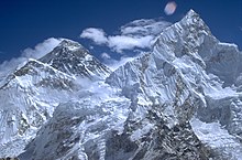
In the Himalayas is the Mount Everest (8848 m) the highest peak. In the West, close to the Himalayan Karakorum -Gebirge with the second highest mountain K2 of (8611 m) and further to the southeast Hindu Kush ( Tirich Mir : 7699 m) and northwest of the Pamir ( Kongur : 7649 m) to. The north of the Himalayas and the Transhimalaya with the "holy mountain" Kailash (6714 m) extending highlands of Tibet ("roof of the world"), the highest and largest plateau on earth, is in the northwest of the Kunlun Shan Mountains and in the Northeast includes the Qilian Shan .
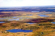
In the north of the Kunlun Shan, beyond the Taklamakan desert and the Tarim basin , the Tian Shan Mountains rise up to 7439 m in the west and the Altai in the east, up to 4506 m . Subsequently, extensive plains, steppes and tundras (see Siberia ) extend to the Arctic Ocean, which are interrupted by some low mountain ranges , including the Kazakh threshold (up to 1566 m), the central Siberian mountainous region (up to 1701 m), the Jenisseibergen (up to 1104 m) and in the extreme northeast the East Siberian mountainous region with its sub-mountains, to which the South Siberian mountains adjoin in the south . In the west, the Urals, up to 1,894 m high, form the boundary of the West Siberian lowlands and the Asian continent.
Further south, in the southwest of the continent, lies the Caucasus ( Elbrus : 5642 m), which is variously regarded as part of the inner Eurasian border, but also as a European mountain range. In the north of Asia Minor , along the coast of the Black Sea , lies the Pontic Mountains , in the west the 2542 m high Uludağ and in the east the 5137 m high Ararat . To the east of Mesopotamia , the Mesopotamia of the Euphrates and Tigris , the Zāgros Mountains rise up to more than 4500 m . Adjoining this in the northeast, between the Caspian Sea and the Iranian Highlands , is the Elburs Mountains ( Damavand : 5671 m).
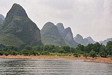
In East Asia there are several other smaller mountain ranges such as the Changbai Mountains on the border between China and North Korea ( Paektusan : 2750 m), the Huang Shan Mountains (lotus blossom peak: 1841 m) in the Chinese province of Anhui and the Karst peaks near the city of Guilin in the autonomous region of Guangxi on Li river . Daoists are five and Buddhists four are the " sacred mountains of China " and are important places of pilgrimage.
Along the east coast of Southeast Asia the Annamite coast chain extends from north to south , in the north of Thailand the Phetchabun Mountains and the Khorat plateau and on the Malay peninsula the foothills of the central Indian chain ( Gunung Tahan : 2187). The only 600 m high Dangrek and Cardamom Mountains ( Phnom Aural : 1813 m) are located on Cambodian territory .
Volcanoes


Volcanoes can be found in large numbers along the so-called “ Pacific Ring of Fire ” - in Asia especially on Kamchatka , Russia, Japan , the Philippines and Indonesia .
On the Russian peninsula of Kamchatka there are 160 volcanoes alone, including the 4750 m high Klyuchevskaya Sopka , 28 of which are active, as well as numerous geysers . In the Philippines, whose more than 7000 islands are almost all of volcanic origin, around 20 volcanoes are active today, including the Pinatubo (1486 m) and the Mayon (2462 m). Among the approximately 240 volcanoes on the Japanese islands, 40 of which are active, Mount Fuji (3776 m; often called Fujiyama in the west ) occupies a special position in people's beliefs (cf. Shintō ). Other volcanoes on the Japanese islands include the Akagi (1828 m), the Ontake-san volcanic massif (Kengamine: 3067 m), the Rishiri (1721 m) and the Bandai volcanic group .
Other volcanoes in Asia can be found in Mongolia, China, the Korean Peninsula, Vietnam and Myanmar, the Andaman Islands , the Indian subcontinent and further west on the Arabian Peninsula , in Iran, Syria, Georgia and Turkey.
Flora and fauna
Biogeographically , Asia consists of two clearly distinguishable flora provinces, the Holarctic and the Paleotropic , both of which, however, also include areas outside of Asia. The border between the two regions lies in the area of the Himlaya. In terms of fauna, the Holarctic is usually divided into two regions, one of which, the so-called Palearctic, comprises the north and west of Asia and beyond that, Europe and North Africa. The second important fauna province of Asia is the Orientalis , which is located in South Asia and coincides with the eastern part of the Palaeotropis. It is separated from the Wallacea region in the south by deep-sea trenches . In addition, a small part of the southern Arabian Peninsula is usually counted among the Afrotropic islands.
Due to the enormous extent of the (sub) continent, only the most important vegetation zones or eco-zones can be mentioned here .
The following climate zones and landscape zones can be distinguished from north to south.
- Treeless tundra north of the Arctic Circle. The most important animals for the nomadic inhabitants like those of the Nenets are the reindeer .
- Forests of the temperate zone , including the boreal coniferous forest (taiga) in Siberia between the Arctic Circle and the course of the Trans-Siberian Railway and deciduous forests in the Far East and in the area of the Caspian Sea. The diverse fauna has (historical) importance for hunting, in addition to agriculture and cattle breeding, the use of wood is also important. Here live z. B. the rare Amur tigers and Amur leopards , as well as deer, wild boar, lynx and bears.
- Continental grasslands or steppes . The animal species that naturally inhabit these steppes include wild horses, saiga antelopes , Mongolian gazelles , wolves and ground squirrels . The nine Tuvinian “pets” can be used as an example : cattle, horses, reindeer, sheep, goats, camels, yaks, dogs, cats.
- Low vegetation, rocky mountain landscapes and desert landscapes . Highland climate with large daytime temperature fluctuations and lots of sunshine. The mountains are populated by numerous mountain grazing animals such as ibex, gorals , serau and wild sheep. The most important predator of the Central Asian mountains is the snow leopard. The desert areas are home to half-donkeys, wild camels, cheetahs and gazelles.
- Tropical savannah areas and dry forests, preferably on the Indian subcontinent, but also in Southeast Asia. Characteristic large animals are lions, stag goat antelopes, Nilgau antelopes and various deer. Today, however, the lion in this area is restricted to a single reserve, the Gir National Park .
- Tropical rainforests . After clearing, the next step in destruction is often the cultivation of monocultures such as palm oil plantations, e.g. B. in Sabah (Malaysia) on Borneo .
- Tropical monsoon areas such as the Mekong Delta : Rice cultivation dominates here and poultry and pigs as farm animals as well as fishing.
swell
- ↑ Unknown Mongolia: A Record of Travel and Exploration in North-West Mongolia and Dzungaria ; Douglas Carruthers; Hutchinson & Co., 1914, ISBN 81-206-0857-7
- ↑ see also regional breakdowns
- ↑ J. Illies (1972): Tiergeographie. 2nd improved edition, (Edwin Fels, Ernst Weigt and Herbert Wilhelmy; original version: 1970). Georg Westermann Verlag, Braunschweig, ISBN 3-14-160285-9


