
Geography of East Timor
.svg)
The geography of East Timor is shaped by its location in the transition from Asia to Australia . East Timor is the only country in Asia whose territory is completely south of the equator . The territory includes not only the eastern half of Timor , but also the exclave Oe-Cusse Ambeno , which is located on the north coast of the Indonesian part of the island, as well as the two small islands Atauro and Jaco .
Location and political boundaries

The island of Timor belongs to the eastern part of the Malay archipelago and is one of the Lesser Sunda Islands . In the northwest of the mountainous island lies the Sawu Sea , to the north the Banda Sea, and south the Timor Sea extends 500 km to Australia. The Timorese call the rough Timor Sea Tasi Mane , the sea of men, while the calm waters north of the island are called Tasi Feto , the sea of women. Just five kilometers from the north coast, the seabed drops to a depth of 1000 m . During the Cold War , American nuclear submarines were therefore able to pass undetected on the streets of Ombai and Wetar . In the Timor Sea, the narrow Timor Trench extends south of the island with a depth of up to 3300 m.
East Timor occupies the entire eastern half of Timor. The Oe-Cusse Ambeno exclave is located on the north coast of the Indonesian part of the island. The island of Atauro is within sight north of the capital Dili . The uninhabited island of Jaco is located off the eastern tip of Timor. With a total area of 14,918.72 km², East Timor is slightly smaller than Schleswig-Holstein or Styria . The main land mass is 260 km long and up to 80 km wide. With the exclave and the associated islands, the maximum east-west extension is 364 km, the maximum north-south extension 149 km. East Timor's coastline is 783 km long. It is surrounded by coral reefs .
The land border with Indonesia is 228 km long. The boundary line had been set at 97% since 2006. Controversial with Indonesia were initially belonging to the small uninhabited island of Fatu Sinai (Pulau Batek) , 37 hectares between Memo (Suco Tapo / memo ) and the Indonesian Dilumi ( district Lamaknen , Region of Belu ) and areas around the enclave of Oe-Cusse Ambeno ( Área Cruz in Passabe , Citrana triangle in Nitibe ) as well as the exact modalities of a corridor from Oe-Cusse Ambeno to the main state territory. Since 2010 there has been a special pass for traffic in the border area. In Naktuka , however, there have been repeated attacks by Indonesian soldiers on the local population since the end of 2009. In 2013 the dispute over the area at Memo was settled. By this time, East Timor had already given up its claims to the island of Fatu Sinai. The two areas on the border of the exclave Oe-Cusse Ambeno remained as points of contention. On July 23, 2019, after a meeting between East Timor's chief negotiator Xanana Gusmão and Wiranto , the Indonesian coordination minister for politics, law and security, it was announced that an agreement had now been reached on the course of the national border. The negotiations on the maritime borders that have been ongoing since 2015 are ongoing.
Geographical names
| German meaning | Local names |
|---|---|
| mountain | Foho T , Gunung I , Monte P |
| top | Pico P |
| island | Ilha P , Pulau I. |
| country | Rain, Rai T |
| sea | Tasi T |
| flow | Mota T , Rio (R.) P , Sungai I |
| Stream | Ribeira (Rib.) P |
| city | Kota I , Prasa T / P , Sidadi T / P , Vila P |
| Village | Kampung I |
| origin | I Bahasa Indonesia, P Portuguese, T Tetum |
| Name part | meaning |
|---|---|
| Ai T | Tree, forest, firewood |
| Fatu T | Mountain, rock |
| Foun T | New |
| Kraik, Craic T , Baixo P. | Lower, lower |
| Leten T , Cima P | Upper |
| Lulik , Lulic T. | holy |
The names of local places, mountains and waters are derived from the regional languages. They mostly describe natural occurrences, also from fauna and flora . Only a few give cultural names, such as “ Fatululic ” for “Holy Mountain”. The origin and meaning of a place name is often not easy to determine. In the western part of the country, for example, the prefix Mau is often found in place names such as Maubisse or Maubara . According to the ethnologist Antoinette Schapper, this prefix is almost typical for the settlement areas of the Mambai , Kemak and Tokodede , all of which speak Austronesian languages . A translation of the also Austronesian Tetum word Maun for "older brother" would give the place name Maumeta the meaning "black brother". Unusual as the population is generally relatively dark-skinned. However, many of the regions were previously inhabited by Papuan peoples, so that the linguist Geoffrey Hull also considers a derivation of Mug ( Bunak ) or Mu′a ( Makasae and Fataluku ), which means "land", possible. “Maumeta” would become “Black Earth”. Schapper, on the other hand, even sees Mau as a sign of an Austronesian first settlement, which contradicts Hull. In fact, in the heartland of the Bunak , the closest ethnic group with the Papuan language , a place name with the prefix Mau does not occur.
Place names of Portuguese origin are rarely found, and if so, then in the capital city of Dili . In the 1930s, Portuguese place names were introduced for various places in the entire colony of Portuguese Timor , but they never caught on and the old names were reverted to a few years after the Second World War . Place names that are of Indonesian origin, such as Delta , a district of Dilis, are even rarer . Indonesian synonyms for Portuguese terms disappeared with the restoration of East Timor's independence. Malay was an important lingua franca in Timor until the 19th century, so place names in East Timor can also be found from this origin.
Different names for the same geographic object are not uncommon. Rivers were traditionally named after the area they were currently flowing through, so the river name changed every few kilometers. In addition, there are often different spellings for all geographic objects. The most common form is usually derived from Portuguese, but during the Indonesian occupation these terms were often adapted to Indonesian, which also corresponds to the phonetic spelling in Tetum. So qu was exchanged for k , so that, for example, the city of Viqueque became Vikeke . Since both Portuguese and Tetum are official languages today, both forms are in everyday use. Internationally, however, the Portuguese form is primarily used. English terms such as Mount , Peak or River are used more and more frequently on maps and in other sources.
In the ministerial document 6/2003 of July 29, 2003, the East Timorese government listed for the first time a notation for all administrative units down to the sucos . On September 15, 2009, the list was expanded to include the Aldeias in ministerial document 199/2009 . In addition, some spellings and names of lower administrative units changed, but even now the spellings do not follow uniform rules, so two neighboring administrative offices in the municipality of Viqueque Uato -Lari and Uatu carbau are called .
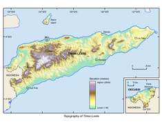
topography


Timor lies on the outer edge of the so-called Banda Arch , which is part of an extension of the Pacific Ring of Fire and forms a chain of islands around the Banda Sea. In an oceanic subduction zone , the northwest corner of the Australian plate is pushed under the Eurasian plate . Among other things, this leads to the growth of mountain ranges on Timor, which, as the central mountainous region, run through almost the entire island from southwest to northeast as far as the Turiscai region . Its peaks are East Timor's highest mountains, the Tatamailau ( 2963 m ) and the Ablai ( 2320 m ), which belong to the Ramelau Mountains . To the north extends from the east of Ermera , over Aileu to the south of Manatuto, the Aileu chain with the Foho Olopana ( 1791 m ) as the highest point. The coastal mountains in the north of Aileu and in Dili form a third chain, so that Timor resembles a washboard due to the folding here. Further to the east are isolated mountains such as the Curi ( 1763 m ), the Monte Mundo Perdido ( 1332 m ) and, beyond the 20 to 30 km wide plain of Quelicai, the Matebian ( 2316 m ). The Paitchau mountain range ( 995 m ) runs along the south coast of the eastern tip of Timor . Some areas in East Timor lift between 1 and 1.6 mm per year. 32.1% of the country's area is between 500 and 1500 m above sea level , 2.6% above 1500 m .
Geologically speaking, East Timor is still very young, as it was only lifted from the sea in the last four million years or so. Due to the geological activities, there is a constant risk of earthquakes and tsunamis . Again and again one feels in Dili tremors from earthquakes around Timor, which however have not caused any damage so far. The northeast of the Oe-Cusse Ambeno exclave forms the youngest and wildest surface structure on the entire island. It is of volcanic origin and with the Sapu (Fatu Nipane) reaches a height of 1259 m . The highest point of Oe-Cusse Ambenos is the Bisae Súnan at 1560 m on the southwest border of the Passabe administrative office . The island of Atauro was also created by volcanism . Its highest point is the Mano Côco at 999 m . There are no longer any active volcanoes in the territory of East Timor. However, there are mud volcanoes in Oesilo (Oe-Cusse Ambeno) and other places . Arthur Wichmann reported on the Raitahu mud volcano near Bibiluto at the end of the 19th century . According to Wichmann, the mud volcano, which is still active today, “ejected water and bituminous substances under the appearance of fire”. According to Wichmann, a second volcano is said to be in Laclubar , but no eruptions have been reported. Volcanic gases escape from the seabed on the so-called Bubble Beach (Suco Lauhata ). There are hot springs in various places in East Timor.
In the north, the mountains drop steeply into the sea. Characteristic coastal terraces and some striking plateaus with a height of 400 to 700 m , such as those of Baucau , shape the picture. Terraces and plateaus were created from corals. The mountainous interior is cut up by valleys. Alluvial land is found between Lautém and Baucau . Larger areas are the plains of Batugade , Metinaro , Dili, Manatuto , Com and on the Lóis River . On the south coast there are wide coastal plains three to ten kilometers wide, characterized by seasonal swamps, swampy forests and areas with high grass cover. They extend from the national border to Viqueque and then narrower to Lore . The largest are the plain of Alas with the southern Lacló river , the Kicras plain with the Sáhen river (Sahe) , the plain of Luca with the river Dilor and the plain of Bibiluto. On the border with West Timor is the flat plateau of Maliana , which used to be a bay.
The most conspicuous plateau of East Timor is the Fuiloro Plateau in the municipality of Lautém. Towards the south it drops, imperceptibly due to its large area, from a height of 700 m to 500 m . Originally the plateau was the lagoon of a primeval atoll . Three other plateaus surround the Fuiloro plateau: the Nári plateaus in the north, Lospalos in the west and Rere in the south.

Overview map

vegetation
topography

gradient


geology

The rocks of Timor belong to the Australian plate, which was raised with the basement ( Lolotoi complex) and became part of the island's central mountain range. In the north of the island there are syn-collisional, metamorphic rocks of the Aileu complex. Younger sediments from the Mesozoic Era and more recent limestones lie in the basins . The most common type of soil is a soft clay soil, which is named after a Timorese region as the Bobonaro complex. This clay is covered with a wild jumble of limestone, lime marl , a mixture of volcanic material and rocks that have been lifted from the seabed to the surface by the seismic forces. Geologists therefore also call Timor a "tectonic chaos". Softer sediments, shale, sandstones and bedded limestones were sheared, crushed and folded into complex and distorted lithologies by the forces that lifted the island. However, the more massive reefs and marine limestones were strong enough to maintain their integrity and were literally pushed through the geological mix in huge upward cuts, such as the Cablac and Matebian mountains and elsewhere along the central mountain range.
The steep slopes of Timor lead to severe erosion, so that the flowing waters carry large amounts of sediment, especially in the rainy season, which lead to extensive and thick sediment fans and flood plains along the rivers and on the coastal plains. Practically all over the country, the surface is formed from such deposits that rest on a bed on hard rock.

geology

Soil types

Soil texture

Soil pH
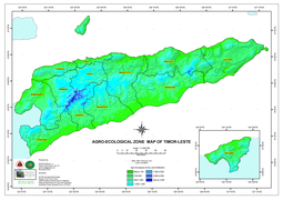
Agroecological zones

Iron and zinc deficiency


Natural resources


Oil is East Timor's most important economic asset. In 2010, the oil sector accounted for 79% of gross domestic product, 67% of gross national income and 58% of gross national income available. Onshore oil reserves were known early on. As early as 1884, the Dilis lamps were supplied with oil from Laclubar . In 2012, 3.965 million tons of crude oil were produced in East Timor, making East Timor the 47th place among the oil-producing countries.
Several oil fields were discovered in the Timor Sea between Timor and Australia during the Portuguese colonial times . These deposits are among the richest in the Asia-Pacific region. On December 11, 1989, Indonesia and Australia signed the Timor Gap Treaty , which divided the resources between the two states. In May 2004 the Australian government reaffirmed the validity of the contract in a form that shifted the sea border, and thus also the raw materials, in favor of Australia. On January 12, 2006, East Timor and Australia agreed in the Treaty on Certain Maritime Arrangements in the Timor Sea (CMATS Treaty) to divide the profits from the oil and gas deposits in the Greater Sun Rise Area in equal shares. A 50-year moratorium on the maritime border was agreed without East Timor waiving its claims. On November 7, 2006, East Timor signed a first contract for the exploitation of five of the eleven blocks of the oil field that had been put out to tender with the Italian ENI group, ten days later a similar agreement was concluded with the Indian Reliance Industries group and finally one in December Joint venture agreed with Kuwait . In January 2017, after a long dispute , the governments of Australia and East Timor announced that the CMATS should be dissolved. In 2019, the new treaty was ratified by the parliaments of Australia and East Timor.
In 2004 the company PetroChina carried out seismic surveys of 70% of the East Timorese mainland for oil deposits. When PetroChina demanded the exclusive exploitation of possible continental oil and gas reserves, the East Timorese government refused.
Other mineral resources are currently not important. There is marble in significant quantities, plus some gold , manganese and copper . Hot springs in some regions indicate geothermal energy . Along the north coast, salt is extracted in several places by the evaporation of sea water in shallow ponds.
Inland waters
.jpg)

Almost all rivers of East Timor have their source in the central mountainous region and, due to the steep gradient, flow towards the north or south. The running waters form a dense hydrographic network in the central island area. As with many small islands with high elevations, these consist almost exclusively of streams, which are rather short, winding and rapidly flowing. However, these streams are dry for most of the year.
Intense precipitation during the rainy season leads to the formation of torrents and thus to severe erosion of the soil. With the end of the rain, however, the level of the streams falls again, so that they can be easily waded through. With the return of the dry winds coming from Australia, only thin rivulets remain in wide river beds full of rubbish and debris that widen each year. The annual floods, which can last a few months, also impede the movement of goods between the fertile plains in the south and the rest of the country. There are efforts to limit the erosion of the banks with the help of plantings and thus to reduce the destruction potential of the brooks. None of the rivers of East Timor are navigable. All year round there are water-bearing rivers, strictly speaking, only in the south of East Timor. The reason for this lies in the longer rainy season compared to the north. Rivers that carry water all year round in the north are fed from the south. This is the case with northern Lacló , which forms the largest hydrographic basin in East Timor, the Seiçal in the municipality of Baucau and the Lóis , the 80 km longest river in East Timor, which empties at Maubara . Southward flowing lead Irabere River (Irabere) , Bebui , Dilor , Tafara , Belulik (Bé-Lulic) , Caraulun River ( Carau-ulun , crucian Ulun ), Southern laclo and Clerec year round water. The main river of the Oe-Cusse Ambeno exclave, the Tono (Nuno-eno) , flows into the sea west of Pante Macassar .
In some permanent rivers along the southern coast, sand collects at the estuaries due to the strong tides, blocking the runoff more and more and leading to the formation of marshland . Sea fish, which have their breeding grounds upstream, and crocodiles live on here until they are driven through a dug exit by the locals in the course of a ritual. Fish, shrimp, snakes and small crocodiles are caught by hand. Marshes easily form on the coasts after the heavy downpours.
The largest lake in East Timor is the Ira Lalaro (also Suro-bec ) in the municipality of Lautém . It has a length of 6.5 km and a width of 3 km. Other inland waters include the Maubara lake and the Tasitol museums . The many waterfalls make the mountainous landscape particularly attractive, the best known is the waterfall of Bandeira near Atsabe .
The waters of East Timor are still little explored. Sometimes there is controversy about their naming, as the waters in the different regions through which they flow have been given different names.
Waters
Watersheds

Hydrogeology
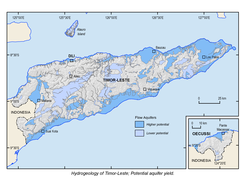
Possibilities for abstraction of groundwater

Groundwater recharge


climate
| Average climate data Dili | |||||||
| year | 2005 | 2006 | 2007 | 2008 | 2009 | 2010 | 2011 |
| Temperature [° C] | 28.8 | 28.9 | 29.4 | 29.3 | 29.5 | 29.5 | 28.9 |
| Precipitation amount [mm] |
945 | 481 | 769 | 1024 | 526 | 1716.4 | 911.8 |


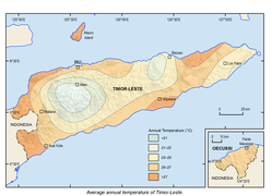
The local climate is tropical , generally hot and humid and characterized by a pronounced rainy and dry season . During the eastern monsoon between May and November, there is often persistent drought, the north coast then receives practically no rain and the brown landscape is parched. Agriculture comes to a standstill during these periods of drought. The cooler mountain regions in the center of the island and the south coast get occasional rain in the dry season, so the landscape here remains green. The rainy season lasts from late November to April. During this time the fields are cultivated again. With the rain often comes floods, the dry river beds can fill up in a very short time and swell into large rivers, dragging the earth and debris with them and breaking roads. For example, in May 2019 through the cyclone Lili . The harvest time follows the end of the rainy season. The capital Dili has an average annual rainfall of 840 mm; most of the rain falls from December to March. In contrast, the city of Manatuto , east of Dili, receives an average of only 565 mm of annual precipitation. The south coast of East Timor is more rainy with 1500 to 2000 mm of annual precipitation; most of the rain falls on the central south coast and the southern mountains. However, the mountains often create a special local microclimate, as a result of which, for example, the place Lolotoe in the municipality of Bobonaro has the highest annual rainfall in East Timor with 2837 mm. There are also very strong differences in the amount of precipitation over the years (see table for Dili).
The temperature in the dry season is around 30 to 35 ° C in the lowlands (20 ° C at night). Parts of the north coast reach temperatures of over 35 ° C at the end of the dry season, but with low humidity and almost no precipitation. In the mountains it is also warm to hot during the day, but at night the temperature can drop to below 15 ° C and significantly lower at higher altitudes. At an altitude of 500 m , the annual average temperature is 24 ° C, at 1000 m at 21 ° C, 1500 m at 18 ° C and at 2000 m at 14 ° C. The wind in Dili is weakest in May with 7 km / h and strongest in August with 12 km / h.
The climate change has an impact on East Timor. In 2016, the El Niño climate phenomenon triggered an extreme drought in East Timor , which resulted in water and food shortages. Harvests failed and 70,000 farm animals died. In 2019, forest fires caused $ 22 million in damage. It is generally expected that the north will dry out more and more, while the south will experience more rain and flooding. By 2050, average temperatures are expected to rise by 1.5 ° C and rainfall by 10%. According to forecasts, the sea level will rise by 1.3 to 2.3 millimeters. Coastal plains are threatened by flooding and the groundwater could become salinized.

Annual rainfall and climate graphs for individual locations
Average
temperature
Change in annual average temperatures in East Timor (1901 and 2018)


| Jan | Feb | Mar | Apr | May | Jun | Jul | Aug | Sep | Oct | Nov | Dec | year | |
|---|---|---|---|---|---|---|---|---|---|---|---|---|---|
| Average temperature [° C] | 28.3 | 28.3 | 28.3 | 28.3 | 28.1 | 27.5 | 26.7 | 26.4 | 26.4 | 27.2 | 28.6 | 28.9 | 27.8 |
| Average daily maximum [° C] | 31.1 | 31.1 | 31.7 | 31.7 | 31.7 | 31.1 | 30.6 | 30.6 | 30.6 | 31.1 | 32.2 | 32.2 | 31.3 |
| Average daily minimum [° C] | 25.6 | 25.6 | 25.0 | 25.0 | 24.4 | 23.9 | 22.8 | 22.2 | 22.2 | 23.3 | 25.6 | 25.6 | 24.2 |
| Absolute temperature maximum [° C] | 36.1 | 35.0 | 36.7 | 36.1 | 35.0 | 36.7 | 33.3 | 35.0 | 33.9 | 33.9 | 35.0 | 35.0 | 36.7 |
| Absolute temperature minimum [° C] | 21.1 | 22.8 | 20.0 | 21.7 | 20.6 | 18.9 | 16.1 | 17.2 | 16.1 | 18.3 | 21.1 | 22.8 | 16.1 |
| Average rainfall [mm] | 127.0 | 119.4 | 137.2 | 109.2 | 86.4 | 25.4 | 12.7 | 5.1 | 7.6 | 22.9 | 50.8 | 139.7 | 843.4 |
| Maximum amount of rain [mm] | 161.9 | 143.9 | 157.4 | 148.4 | 149.8 | 139.2 | 137.1 | 130.1 | 127.5 | 149.6 | 159.9 | 168.6 | 1773.5 |
| Average number of rainy days | 13 | 13 | 11 | 9 | 6th | 4th | 3 | 1 | 1 | 2 | 6th | 11 | 80 |
| Average duration of sunshine [h / d] | 6.1 | 5.7 | 7.6 | 7.8 | 8.6 | 8.2 | 8.8 | 9.4 | 9.6 | 9.6 | 9.0 | 7.1 | 8.1 |
| Average water temperature [° C] | 26.7 | 26.4 | 26.4 | 27.2 | 28.6 | 28.9 | 28.3 | 28.3 | 28.3 | 28.3 | 28.1 | 27.5 | 27.8 |
| Average relative humidity [%] | 80 | 82 | 80 | 77 | 75 | 72 | 71 | 70 | 71 | 72 | 73 | 77 | 75 |
| Average wind speed [km / h] | 10 | 8th | 9 | 8th | 7th | 8th | 10 | 12 | 11 | 11 | 11 | 10 | - |
| season | Rainy season | dry season | RZ | ||||||||||
Source: Phytosociological Research Center ; wetterkontor.de ; Direcção Nacional de Estatística: Timor-Leste in figures 2011 (PDF; 3.8 MB) , accessed on May 5, 2013
fauna and Flora


The island of Timor is part of Wallacea , an area of the biogeographical transition zone between the Asian and Australian flora and fauna . However, there are only a few Australian species, such as the gray cuscus . The few mammal species on Timor , such as the maned deer , musangs , species of taxa fruit bats , shrews and monkeys , as well as birds and insects, resemble common Malay phenotypes . However, 23 bird species are only found in the Timor and Wetar Endemic Bird Area , which makes East Timor particularly interesting for ornithologists . The approximately 240 species of birds include numerous species of parrots as well as amadines , cockatoos and the wetar pigeon .
East Timor can only come up with a few species of frogs from the class of amphibians , which are mostly not endemic , i.e. only restricted to Timor. After all, a field study between 2004 and 2009 found several previously not described species. Also reptiles enrich the wildlife Timor, such as named after the island of Timor Monitor ( Varanus timorensis ), the Timor-liasis ( Liasis mackloti ) and living in the sea of Timor-Riffschlange ( Aipysurus fuscus ). Endemic is the Timor tortoise, which lives on the eastern tip of the island and was only discovered in 2007, which is regarded partly as a subspecies of McCord's snake- necked tortoise ( Chelodina mccordi ) and partly as a separate species Chelodina timorensis .
The estuarine crocodile , known as the “grandfather crocodile”, lives in the sea and rivers . According to legend, the island of Timor was created from a crocodile. CrocBITE, the database for crocodile attacks at Charles Darwin University , has registered 15 fatal and five other attacks on people in East Timor since 2007 (as of September 2016). Pets are also being torn more and more often, which is why a crocodile task force of ten men was set up in 2010 .
The only pure freshwater fish that are native to the rivers of Timor are the only four centimeters long endemic Oryzias timorensis from the rice fish family (Adrianichthyidae) and Craterocephalus laisapi from the hard-headed genus, which is endemic to the East Timorese river Irasiquero . There are also about 40 other species, but rather in the brackish waters of estuaries and mangroves live, including the families of the ariidae (Ariidae), the gobies (Gobiidae), the archer fish (Toxotidae) and Kuhlia Mugil from the family of flag Dick (Kuhlia). The carp , the African catfish and Cyprinodontiformes Guppy , Koboldkärpflinge and Panchax were introduced by man. The endemic Eviota santanai was discovered on the coast of the eastern tip of Timor in 2013 . The waters around Timor belong to the so-called Coral Triangle , a region with the greatest biodiversity of corals and reef fish in the world. The reefs around the island of Atauro provide the highest value for fish. Up to 314 species were discovered in individual places in 2016, a value that is nowhere surpassed in the world. A total of 643 fish species have been identified around Atauro, several of which have not even been scientifically described. In 2017, for example, the small sea fish Helcogramma atauroensis , which is named after the island, was described for the first time .
It is estimated that there are around 2500 species of plants in East Timor. In a 2006 field study alone, 22 new species were discovered. The vegetation of East Timor consists mainly of secondary forest , savannas and grasslands . There are mostly species from the casuarina family , the genus eucalyptus , the genus sappan wood , sandalwood and palmyra palms (Lontar palms). The total area of forest in East Timor (excluding Oe-Cusse Ambeno) decreased by almost 30% between 1972 and 1999. In the last ten years of the Indonesian occupation alone, the proportion of forests in the whole of East Timor fell by 18%. The area of the original primary forest of East Timor has shrunk to 220,000 hectares, or one percent of the territory . Dense forest can only be found in the south of the country and in the mountain regions. Mangrove forests cover only about 7500 hectares of East Timor, as in contrast to other islands in the archipelago there are only a few bulges in the coastline. These occur mainly on the north coast, where the sea is calmer. For example, you can find mangrove forests at Metinaro , Tibar and Maubara . On the south coast, the mangroves do not extend much further than beyond the estuaries and swampy terrain.
Administrative division

In 2004 the administrative boundaries were revised. In 2014/2015 the previous districts ( Portuguese Distrito ) were renamed municipalities ( Portuguese Município ) and the subdistricts ( Portuguese Subdistrito ) into administrative offices ( Portuguese Posto Administrativo ). A decentralization of the administration with the creation of the communities has been planned since 2009. To this end, a municipal administration and a municipal council are to be created. A mayor should ensure the implementation of the resolutions and be responsible for the municipal administration. Law 4/2014 placed most of the district-level authorities under the administrators who were still appointed by the central government and provided them with a larger budget from the central government. The basic problem with decentralization is that, even at the national level, there are not enough trained staff to fill the administration.

East Timor has twelve municipalities and the Special Administrative Region ( Portuguese Região Administrativa Especial ) Oe-Cusse Ambeno, which has a special role. In Article 71 of the East Timorese Constitution, Oe-Cusse Ambeno guarantees this in administration and economic policy. However, the actual implementation of this constitutional article was initially lacking. It was not until June 18, 2014 that the Autoridade da Região Administrativa Especial de Oecusse (ARAEO) was created with Law 03/2014 .
The municipalities are divided into a total of 65 administrative offices, 452 sucos and 2233 aldeias . The island of Atauro forms its own administrative office in the municipality of Dili, the island of Jaco is part of the Sucos Tutuala in the municipality of Lautém.
The boundaries of the administrative units were partially redrawn in 2015. New sucos were created in 2017.

Municipalities of East Timor since 2015

Administrative offices of East Timor since 2015

Sucos East Timors until 2015


| Municipality (number on the card) | ISO 3166-2: TL | Inhabitants (2004) | Population (2015) | Area in km² | Capital | Human Development Index (2017) |
|---|---|---|---|---|---|---|
| Aileu (6) | TL-AL | 37,926 | 48,837 | 735.94 | Aileu | 0.613 |
| Ainaro (10) | TL-AN | 52,476 | 63.136 | 802.59 | Ainaro | 0.560 |
| Baucau (2) | TL-BA | 100,326 | 123.203 | 1,504.17 | Baucau | 0.602 |
| Bobonaro (11) | TL-BO | 97,762 | 98,932 | 1,378.10 | Maliana | 0.606 |
| Cova Lima (12) | TL-CO | 52,818 | 65,301 | 1,198.59 | Suai | 0.618 |
| Dili (5) | TL-DI | 173,541 | 277.279 | 364.12 | Dili | 0.733 |
| Ermera (9) | TL-ER | 103.199 | 125,702 | 756.47 | Gleno | 0.562 |
| Lautém (1) | TL-LA | 55,921 | 65,240 | 1,816.68 | Lospalos | 0.607 |
| Liquiçá (8) | TL-LI | 54,834 | 71,927 | 559.92 | Liquiçá | 0.636 |
| Manatuto (4) | TL-MT | 36,719 | 46,619 | 1,783.34 | Manatuto | 0.614 |
| Manufahi (7) | TL-MF | 44,950 | 53,691 | 1,332.50 | Seed | 0.618 |
| Oe-Cusse Ambeno (13) | TL-OE | 57,469 | 68,913 | 813.62 | Pante Macassar | 0.553 |
| Viqueque (3) | TL-VI | 65,245 | 76.033 | 1,880.39 | Viqueque | 0.602 |
Settlements

The state capital Dili is by far the largest city in East Timor. It has, including the island of Atauro and the rural areas belonging to the municipality, 277,279 inhabitants (as of 2015). Dili is on the north coast, as is the second largest city, Baucau . It has 17,357 inhabitants (2015) The other main towns of the individual communities of East Timor are also considered cities and are each the largest settlements there. Only in the municipality of Ainaro is there a second city in a municipality with Maubisse in the north.
Infrastructure
| Distances [km] | |||||||||||||
| place | DI | PM | VI | SU | SA | MT | ML | LO | LI | HE | BA | ON | AL |
| Aileu | 47 | 145 | 230 | 113 | 54 | 134 | 196 | 295 | 79 | 29 | 169 | 51 | |
| Ainaro | 78 | 127 | 134 | 69 | 60 | 123 | 49 | 247 | 82 | 55 | 183 | 51 | |
| Baucau | 122 | 243 | 61 | 223 | 159 | 60 | 208 | 126 | 154 | 155 | 183 | 169 | |
| Ermera | 58 | 123 | 164 | 104 | 65 | 95 | 55 | 306 | 67 | 155 | 55 | 29 | |
| Liquiçá | 32 | 126 | 215 | 131 | 90 | 119 | 117 | 280 | 67 | 154 | 82 | 79 | |
| Lospalos | 248 | 300 | 187 | 282 | 217 | 186 | 397 | 280 | 306 | 126 | 247 | 295 | |
| Maliana | 149 | 95 | 332 | 61 | 87 | 236 | 397 | 117 | 55 | 208 | 49 | 196 | |
| Manatuto | 87 | 194 | 96 | 189 | 115 | 236 | 186 | 119 | 95 | 60 | 123 | 134 | |
| Seed | 81 | 140 | 105 | 84 | 115 | 87 | 217 | 90 | 65 | 159 | 60 | 54 | |
| Suai | 138 | 97 | 169 | 84 | 189 | 61 | 282 | 131 | 104 | 223 | 69 | 113 | |
| Viqueque | 183 | 220 | 169 | 105 | 96 | 332 | 187 | 215 | 164 | 61 | 134 | 230 | |
| Pante Macassar | 154 | 220 | 97 | 140 | 194 | 95 | 300 | 126 | 123 | 243 | 127 | 145 | |
| Dili | 154 | 183 | 138 | 81 | 87 | 149 | 248 | 32 | 58 | 122 | 78 | 47 | |
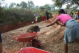
70% of the 5320 kilometers of road are in need of repair. In the rainy season, many of the paths are only muddy slopes and no longer passable. There are 1,426 km of national roads, 869 km of municipal roads and 3,025 km of local roads. The main traffic routes are the two coastal roads on the north and south coast of the country, which are connected by five overland roads in a north-south direction. There are also two cross-connections inland. The first section of the Suai – Beaco motorway , from Suai to Fatukaho (Fatukahu) , opened in 2018 and is East Timor’s first ever motorway. There are around 450 bridges in the country (as of 2013).
Dili 's Presidente Nicolau Lobato Airport is located west of the city center in Suco Madohi and is the only international airport to be served by passenger planes . There are connections to Australia and Indonesia. Regular, civil flight connections to other airports in East Timor are currently not recorded in the airlines' international booking system. For airport Oecusse District , there is a flight connection with a two-propeller engine of the local authority. Even the Suai airport has since been expanded. The Baucau airport is the only airport of East Timor, can land at the larger machines than the Boeing 737th It is primarily used for military and supply flights.
Dili has the main shipping port in the country. It is located on the west bank of Dili Bay , near the center of the city. A new port has been under construction in the Bay of Tibar since 2019. In Beaco , on the south coast, a natural gas terminal for ships for 943 million US dollars is to be built by a Chinese company within four years, once the financing is cleared.
There are border crossings from the main state of East Timor to Indonesia in Mota'ain , near the north coast, and in Motamasin , on the south coast to the Indonesian West Timor. There is no regular bus service. From Oe-Cusse Ambeno, border crossings at Napan / Bobometo ( Oesilo administrative office ), Sacato / Wini and Passabe lead to West Timor. However, only Bobometo and Sacato are legal transitions.
Road construction in East Timor

River crossings without a bridge are often necessary

The Presidente Nicolau Lobato Airport in Dili


.jpg)
See also
- List of mountains or elevations in East Timor
- List of caves in East Timor
- List of waterfalls in East Timor
literature
- Audley Charles: The Geology of Portuguese Timor , 1968.
- Economic and Social Commission for Asia and the Pacific: Geology and Mineral Resources of Timor-Leste, United Nations 2003, limited preview in Google Book search.
- Manuel Delio, José Faria Mafaldo: PRELIMINARY IDENTIFICATION OF GEOTOURISM POTENTIAL: TOURIST ZONES OF EASTERN, CENTRAL AND WESTERN PART OF TIMOR-LESTE (Lautem, Baucau, Dili, Ainaro, Ermera and Bobonaro Municipality) , Unidade USJientista Jeolojia TimorL.
- Francisco da Costa Monteiro , Vicenti da Costa Pinto: Exploring Timor-Leste: Minerals Potential , Pacific Econ. Cooperation Council-PECC Minerals Network, Brisbane, Queensland, Nov 17-18, 2003.
- Kim S. Ely, Mike Sandiford, Margaret L. Hawke, David Phillips, Mark Quigley, Joao Edmundo dos Reis: Evolution of Ataúro Island: Temporal constraints on subduction processes beneath the Wetar zone, Banda Arc , Journal of Asian Earth Sciences 41 (2011 ), Pp. 477-493.
- Pedro Laranjeira: Sistema de Informação Geográfica para Timor-Leste , dissertation, Universidade de Trás-os-Montes e Alto Douro 2010.
- SJ Thompson: Geology and Soils in Timor-Leste , 2011 (with numerous maps).
- United Nations: Atlas of Mineral Resources of the ESCAP Region, Volume 17: Geology and Mineral Resources of Timor-Leste
- Johannes Wanner : Paleontology of Timor: together with smaller contributions to the paleontology of some other islands of the East Indian archipelago , 1920.
Web links
- Logan Barber: Tectonic Evolution of the Cablac Formation, East Timor ( February 28, 2009 memento in the Internet Archive )
- Seeds of Life Timor: Geology and Soils in Timor-Leste
- Maps of the geology of East Timor
Individual evidence
- ^ Maeve McCusker, Anthony Soares Soares: Islanded Identities: Constructions of Postcolonial Cultural Insularity. 2011, ISBN 978-90-420-3406-8 , p. 170.
- ↑ a b c d Direcção-Geral de Estatística : Results of the 2015 census , accessed on November 23, 2016.
- ↑ Important Bird Areas in Timor-Leste ( Memento of November 30, 2010 in the Internet Archive ) (English; PDF file; 1.87 MB), accessed on September 25, 2012.
- ↑ a b c d e Direcção Nacional de Estatística: Timor-Leste in figures 2011 (PDF; 3.8 MB) ( Memento from February 19, 2014 in the Internet Archive ), accessed on May 5, 2013.
- ↑ Direcção Nacional de Estatística: Timor-Leste in Figures 2008 , accessed on May 20, 2012 ( Memento of July 7, 2010 in the Internet Archive ) (PDF; 3.7 MB)
- ↑ Wikinews, July 28, 2010, border disputes between Indonesia and Timor-Leste threaten to escalate
- ↑ Vivanews, November 7, 2009, Indonesia - E Timor under Borderline Dispute ( Memento of February 25, 2010 in the Internet Archive )
- ↑ RTP: Timor-Leste e Indonésia chegam a acordo para definição de fronteira terrestre , July 23, 2019 , accessed on July 23, 2019.
- ↑ Jakarta Post: RI, Timor Leste agree to resolve border problems, boost ties , August 27, 2015 , accessed August 28, 2015.
- ^ Dictionary Tetum - English, accessed May 20, 2012
- ↑ a b c d University of Coimbra - The geomorfology of Timor-Leste, accessed on May 20, 2012 ( Memento of December 9, 2007 in the Internet Archive )
- ^ A b Antoinette Schapper: Finding Bunaq: The homeland and expansion of the Bunaq in central Timor. ( Memento of October 24, 2013 in the Internet Archive ) In: Andrew McWilliam, Elizabeth G. Traube: Land and Life in Timor-Leste: Ethnographic Essays. 2011, p. 179.
- ^ A b Geoffrey Hull : The placenames of East Timor. In: Placenames Australia (ANPS): Newsletter of the Australian National Placenames Survey, June 2006, p. 6 f. ( Memento of February 14, 2017 in the Internet Archive ) Retrieved September 28, 2014.
- ↑ The Permanent Committee on Geographical Names: East Timor - Geographical names against a volatile background, 1999 ( Memento of February 9, 2013 in the Internet Archive ) (PDF; 64 kB)
- ↑ Ministério da administração estatal: Diploma Ministerial n. ° 6/2003 ( Memento of September 29, 2007 in the Internet Archive ) (Portuguese), July 29, 2003.
- ↑ Jornal da Républica with the Diploma Ministerial n. 199/2009 ( Memento of February 3, 2010 in the Internet Archive ) (PDF; 315 kB) (Portuguese)
- ^ A b c Colin Richard Trainor, Brian Coates, David K. Bishop: Aves de Timor-Leste. Burung-burung di Timor-Leste. The Birds of Timor-Leste , p. 67 ff. (Portuguese, Indonesian, English)
- ↑ a b ECONOMIC AND SOCIAL COMMISSION FOR ASIA AND THE PACIFIC: ATLAS OF MINERAL RESOURCES OF THE ESCAP REGION, Volume 17, Geology and Mineral Resources of Timor-Leste, United Nations , p. 7, accessed on March 19, 2013.
- ↑ a b Nova Roosmawati, Ron Harris: Surface uplift history of the incipient Banda arc-continent collision: Geology and synorogenic foraminifera of Red and Savu Islands, Indonesia. In: Tectonophysics. 479, 2009, pp. 95-110. doi: 10.1016 / j.tecto.2009.04.009
- ↑ Direcção Nacional de Estatística: Census of Population and Housing Atlas 2004
- ^ Geographic.org: Nuaf Sapu
- ↑ Mapa do enclave de Oecussi Ambeno , AMOC - Associação dos Militares do Oecussi ( Memento from June 24, 2014 in the Internet Archive )
- ^ Collections of the Geological Museum in Leiden, Arthur Wichmann: Rocks from Timor and some neighboring islands . Leiden, EJ Brill, 1882-1887 1, volumes 10-11, p. 165.
- ↑ a b c d e f g h i j k l m n o p q r Seeds of Life , accessed July 5, 2014.
- ↑ a b c S.J. Thompson, Dili, Timor-Leste: Geology and Soils in Timor-Leste , December 16, 2011 , accessed December 4, 2019.
- ↑ James J. Fox: The Paradox of Powerlessness: Timor in Historical Perspective , December 9, 1996, Department of Anthropology, Research School of Pacific and Asian Studies, The Australian National University ( Memento of July 6, 2007 in the Internet Archive ) (PDF ; 70 kB)
- ↑ Direcção Nacional de Estatística : Timor-Leste's National Accounts 2004–2010 Volume I ( Memento of September 28, 2013 in the Internet Archive ) (PDF; 8.7 MB) , accessed on May 18, 2013.
- ↑ History of Timor ( Memento of March 24, 2009 in the Internet Archive ) - Technical University of Lisbon (PDF; 805 kB)
- ↑ http://www.factfish.com/country-category/timor-leste/energy%20and%20environment
- ↑ Uniya - Jesuit Social Justice Center ( Memento from April 14, 2011 in the Internet Archive )
- ↑ Sydney Morning Herald Australia's unscrupulous pursuit of East Timor's oil needs to stop , January 11, 2017 , accessed January 20, 2017.
- ↑ Voice of America: Australia Ratifies Maritime Boundaries with East Timor , July 29, 2019 , accessed July 30, 2019.
- ↑ Loro Horta : "Timor-Leste - The Dragon's Newest Friend", 2009 (PDF; 103 kB), accessed on May 20, 2012.
- ↑ UN studies on mineral deposits in East Timor ( Memento from September 26, 2007 in the Internet Archive ) (PDF; 5 MB)
- ^ Asian Development Bank: TIM: District Capitals Water Supply Project - Rehabilitation of Lake Lehumo , September 2011 , accessed February 23, 2014.
- ↑ Caritas Australia, CARE, Oxfam, Plan, World Vision: 'The Unreported Drought - El Nino's Impact in Timor-Leste' , June 17, 2016 , accessed on July 12, 2016.
- ↑ a b Tempo Timor: Timor-Leste suffers climate change , December 2, 2019 , accessed on December 3, 2019.
- ↑ Seeds of Life Timor-Leste: Climate Change , accessed December 8, 2012.
- ↑ Ed Hawkins: Institute for Environmental Analytics , accessed June 24, 2019.
- ↑ Hinrich Kaiser u. a .: The herpetofauna of Timor-Leste: a first report. Retrieved May 20, 2012.
- ↑ Hinrich Kaiser u. a., Department of Biology, Victor Valley College: The herpetofauna of Timor-Leste: a first report.
- ↑ CrocBITE - Worldwide Crocodilian Attack Database , accessed September 4, 2016.
- ^ Press Release of Presidency of the Republic: Crocodile Task Force train with the best of the best. May 3, 2012.
- ↑ Craterocephalus laisapi on Fishbase.org (English)
- ^ FishBase : List of Freshwater Fishes for East Timor
- ↑ Country's First New Species of Fish Discovered, December 11, 2013 , accessed December 13, 2013.
- ^ The Guardian: Atauro Island: scientists discover the most biodiverse waters in the world , accessed on August 21, 2016.
- ↑ Ben Koses: Expedition draws world's attention to new crown jewel of marine life , in: humanature Conversation International blog , accessed on August 21, 2016.
- ↑ Ronald Fricke, Mark V. Erdmann: Helcogramma atauroensis, a new species of triplefin from Ataúro Island, Timor-Leste, eastern Indian Ocean (Teleostei: Tripterygiidae) , Journal of the Ocean Science Foundation, 26, 34–45 (2017), urn: lsid: zoobank.org: pub: 612DE10C-E89B-4C08-ADF9-598BC068B0AF doi: 10.5281 / zenodo.377034
- ↑ GOVERNMENT OF TIMOR-LESTE, THROUGH THE SECRETARIA DE ESTADO DOS RECURSOS NATURAIS: Tasi Mane - Suai Supply Base EIA Terrestrial Flora and Fauna Technical Report , March 23, 2012.
- ^ Laura Suzanne Meitzner Yoder: Custom, Codification, Collaboration: Integrating the Legacies of Land and Forest Authorities in Oecusse Enclave, East Timor. P. 104, dissertation, Yale University, 2005 ( PDF file; 1.46 MB ( memento of March 7, 2007 in the Internet Archive )).
- ↑ Jornal da República: Diploma Ministerial no 24/2014 de 24 de Julho - Orgânica dos Postos Administrativos ( Memento of March 4, 2016 in the Internet Archive ), accessed on November 9, 2015.
- ↑ Ministério da Administração Estatal: Município de Aileu ( Memento of June 20, 2016 in the Internet Archive ) as an example, accessed on November 9, 2015.
- ↑ Government Page: Council of Ministers Approves Law Proposals on Local Governance ( Memento of 8 April 2015, Internet Archive ), called on 20 May 2012 found.
- ↑ Terry Russell: Decentralization and rural development in Timor-Leste , April 3, 2015, East Timor Forum , accessed April 7, 2015.
- ↑ Jornal da República: DECRETO LEI No. 5/2015 de 22 de Janeiro - Estatuto da Região Administrativa Especial de Oe-Cusse Ambeno ( Memento of March 4, 2016 in the Internet Archive ), accessed on November 9, 2015.
- ^ Constitution of East Timor (Portuguese), accessed May 29, 2015.
- ^ Laura Suzanne Meitzner Yoder: Custom, Codification, Collaboration: Integrating the Legacies of Land and Forest Authorities in Oecusse Enclave, East Timor. P. 25, Dissertation, Yale University, 2005 ( PDF file; 1.46 MB ( memento of March 7, 2007 in the Internet Archive )).
- ^ Timor-Leste Ministry of Finance: Oé-Cusse: the beginning of a better future for Timor-Leste , accessed on February 3, 2015.
- ↑ Jornal da Républica with the Diploma Ministerial n. 199/09 ( Memento of February 3, 2010 in the Internet Archive ), accessed on May 20, 2012 (PDF; 315 kB)
- ↑ cf. Maps in Direcção-Geral de Estatística: TIMOR-LESTE EM NÚMEROS / TIMOR-LESTE IN FIGURES 2014 and Population and Housing Census 2015 Preliminary Results , both accessed on July 30, 2016.
- ↑ Direcção-Geral de Estatística: Timor-Leste in Number 2017 , accessed on March 8, 2019.
- ↑ Direcção Nacional de Estatística: Census 2004 ( Memento from September 6, 2014 in the Internet Archive ), accessed on October 18, 2014.
- ^ Sub-national HDI - Area Database - Global Data Lab. Retrieved December 8, 2018 .
- ↑ a b Timor-Leste, Eleições Gerais de 2012 , accessed on September 2, 2012.
- ^ Government of East Timor: ON THE OCCASION OF THE INAUGURATION OF SECTION 1 (SUAI FATUKAHU / MOLA) OF THE HIGHWAY , November 17, 2018 , accessed on December 22, 2018.
- ↑ SAPO: Projeto de Porto de Tibar reconhecido com prémio internacional , April 9, 2019 , accessed on April 30, 2019.
- ↑ e-global: Timor-Leste: Eempresa Chinesa vai construir porto no sul do território timorense , April 29, 2019 , accessed on April 30, 2019.
- ↑ Sobar Sutisna and Sri Handoyo: Delineation and Demarcation surveys of the land border in Timor: Indonesian perspective , Center for Boundary Mapping, The National Agency for Surveys and Mapping of Indonesia , accessed on November 18, 2018
47 Asian member states of the United Nations :
Afghanistan |
Egypt |
Armenia |
Azerbaijan |
Bahrain |
Bangladesh |
Bhutan |
Brunei |
China |
Georgia |
India |
Indonesia |
Iraq |
Iran |
Israel |
Japan |
Yemen |
Jordan |
Cambodia |
Kazakhstan |
Qatar |
Kyrgyzstan |
Kuwait |
Laos |
Lebanon |
Malaysia |
Maldives |
Mongolia |
Myanmar |
Nepal |
North Korea |
Oman |
East Timor |
Pakistan |
Philippines |
Russia |
Saudi Arabia |
Singapore |
Sri Lanka |
South Korea |
Syria |
Tajikistan |
Thailand |
Turkey |
Turkmenistan |
Uzbekistan |
United Arab Emirates |
Vietnam |
Cyprus
Other areas:
British Indian Ocean Territory |
Hong Kong |
Macau |
Palestine
Disputed States:
Abkhazia |
Nagorno-Karabakh Republic |
South Ossetia |
Turkish Republic of Northern Cyprus
Geography of the States of:
Africa |
Europe |
North America |
Oceania |
South America