
Geography of iran

The Iran lies in the large Euro-Asian high mountain belt, which extends from the Iberian Peninsula over the Alps , Carpathians , Balkans , Taurus and Pontus in the two Iranian border mountains Alborz and Zagros continues, to the east of the Central Asian Hindu Kush and the Karakoram connect and the The Himalayas, also part of the Alpid mountain belt .
Furthermore, Iran belongs to the dry belt of the northern Passat Zone , which extends in the west over the Arabian Peninsula on the Arabian Plate and the Sahara to the Atlantic Ocean and in the east merges into the inland deserts of Central Asia north of the tropic .
National territory


The national territory extends from 25 ° to 40 ° north latitude and 44 ° to 64 ° east longitude. The capital is Tehran. The city is on the same latitude as Crete or Gibraltar. With an area of 1,648,195 km², Iran is around four and a half times the size of Germany. The time difference between Iran and CET is: CET + 2.5 hours.
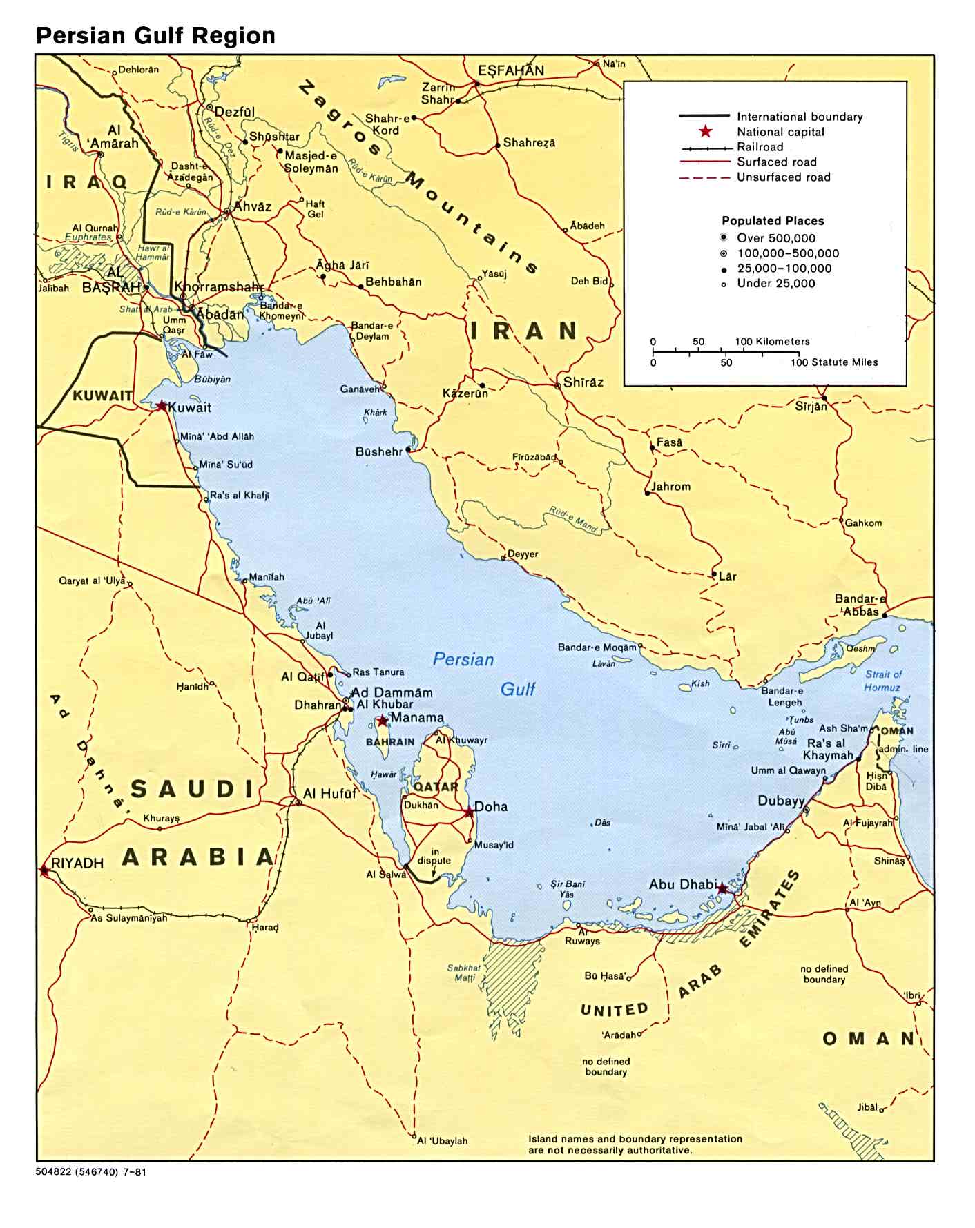
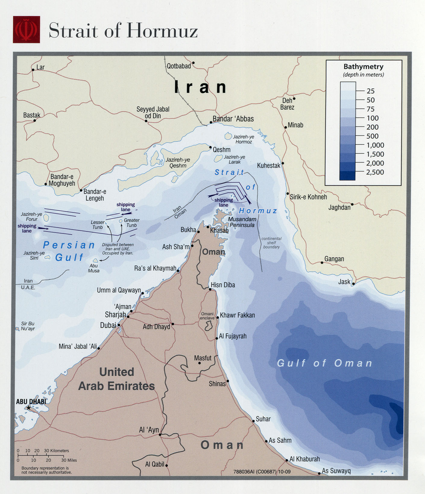
In the south, Iran borders the Gulf of Oman and the Persian Gulf . The Iranian coast does not come up with indented coastal structures. Instead, there are several islands in front of them, some of which are of considerable strategic importance. The Qeschm free trade zone is the largest of these islands and is known for its extensive drinking water production . Historically, the island has also achieved considerable importance, because many empires of the country based their positions there. For example the old kingdom of Elam from the west (today's provinces of Chusistan and Luristan), the Umayyad caliphate dynasty , the Hashemite Abbasids , and ultimately the British and Portuguese. These include the island of Hormuz , located on one of the still most important straits in the world, the Strait of Hormuz , the island Larak from which the first Gulf War between Iran and Iraq ran out on vital oil supplies, or for tourism , the Kisch or, ultimately, Kharg, an important island for relaxation , also made famous in the first Gulf War, as a not always environmentally friendly oil loading station.
In the west, Iran borders Iraq. The border initially follows the border river Shatt al-Arab , a confluence area of the Euphrates and Tigris . The exact course of the border has been a matter of dispute for some time. To the west of today's Kermanshah province , the border runs north, crosses the Mesopotamian lowlands, follows the foot of the Zagros Mountains and enters these mountains at Qasr-e Schirin . The border continues through hard-to-reach Kurdish mountainous areas, partly follows the watershed between Lake Van and Lake Urmia and reaches the border with the Republic of Armenia at Ararat on the Aras River .
At Pars Abad in the far north of the country on the border with Armenia, the border line curves to the southeast. It runs through the mountains of Talisch into the Gilanian Astara on the shores of the Caspian Sea and is there against Azerbaijan . The city is 28 m below the level of the ocean. The border now follows the south bank of the Caspian Sea, then the Atrak River and the north face of the Kupat Dagh Mountains.
East of the second most important pilgrimage city of Iran, Mashad , swings the limit strictly to the south and runs along the coming from the Hindu Kush river Hari Rud , which ensures the supply of drinking water in the region of Mashhad, by a pelvic zone in the province of Khorasan , in which several from Afghanistan losing inflowing rivers.
40 km from the lying on the border with Pakistan city of Zahedan , lies on the top of Kuh-e Malek Siyah the three borders Afghanistan, Pakistan and Iran , from where the border in a-flung eastward bow through the inhospitable mountains of Balochistan after Runs south and finally reaches the Gulf of Oman 100 km east of the port city of Tschahbahar .
The 5440 km national border is divided into Iraq, Turkmenistan, Afghanistan, Pakistan, Azerbaijan, Turkey and Armenia. 2,440 km of the coastline are in the Persian Gulf or the Indic and 740 km in the Caspian Sea.
The land use of Iran is divided as follows: forest 10.9%, agriculture 35.7%, water 0.7% and desert 50.0% (status: 1994).
Natural spaces


Due to the mountainous character and the arid climate, Iran has only very limited areas of agricultural use. Of the total area of Iran, 53.4% is desert and barren land, 26.7% is pasture, 10.9% is forest and only the remaining 9% is arable land.
- The coastal lowlands on the Caspian Sea with the provinces of Gilan in the west and Mazanderan in the east occupy a special position. In contrast to all other regions, annual precipitation amounts of up to 2000 mm are recorded here. This region is the most humid in Iran and for this very reason it is also the most important agricultural production area. The rice fields of Rasht are well known . Likewise the tea plantations of Lahidschan . To the east of it in Mazanderan there are significant cotton areas. The north along the Caspian Sea is rainy and fertile. On the slopes of the mountains there are still extensive deciduous and mixed forests. The wood stocks of the provinces of Gilan and Mazandaran are used by the wood processing companies in Asalem and Neka. In addition to rice, tea and cotton, tobacco and citrus fruits are cultivated, and fish is caught on the coast, especially sturgeon, which provides the world-famous caviar.
- To the south, the lowland rises abruptly to the edge of the Alborz mountains , which continues in the west in the Talysh Mountains and in the east in the mountains of Khorasan . The peaks of the central parts of the Alborz reach heights of over 4000 m several times, with the volcanic cone of the Damavand even 5671 m. Damavand and Alam Kuh are glaciated mountains. The northern slopes of the Alborz mountain range, exposed to the winds of the Caspian Sea, are humid and covered with dense mountain forests. The south side is dry and noticeable without forests. Here the steppe or desert character of the inner Iranian highlands already prevails.
- At the transition from the Alborz to the Central Asian high plateau, wide footprints of the mountains extend. Since only there is enough water available, all the larger cities of the highlands are on the edge of it. The water is mostly supplied from the mountains via up to 250 km long underground channels, the so-called qanats .
- The inner Iranian highlands extend over 1200 km from northwest to southeast. It is divided into several basins by various mountain ranges and thresholds, which sometimes break up into numerous smaller depressions. The largest basins are beyond the sacred capital Qom . These are the Kawir and the Lut . As far as inner Iranian mountain ranges rise above 2500 m, the height of the basins decreases towards the southeast. The deepest parts of the basins of Qom and the great Kavir are around 800 m, those of the Lut basin are only just over 200 m high. Iranian deserts are almost never sandy, but mostly gravel or salt deserts. The salt flats can turn into dangerous swamps during the humid season.
- To the west and south of the highlands are the Zagros Mountains . The mountains start at the mountain nodes in eastern Anatolia and northwestern Iran and move to the southeast. In contrast to the Alborz Mountains, the Zagros consists of numerous mountain ranges staggered one behind the other, which run out to the east. Its highest peaks initially rise well over 4000 m, but are not glaciated. The south-west slopes of the mountains, exposed to the damp westerly winds, bear the remains of the original oak bush forest. The basins of Bakhtaran, Hamadan , Isfahan and Shiraz lie between the parallel mountain ranges .
- The coastal lowlands extend along the Persian Gulf . In its center it forms only a narrow strip, but in Khuzestan in the west and on the macro coast of Baluchistan in the east it occupies a much wider space. Khusestan has always been an extremely important and fertile agricultural area. The settlements there, as well as the oil refineries, were largely destroyed by the first Gulf War. Due to the high humidity and the very high temperatures, relatively few people live in the central and coastal area belonging to Balochistan.
Physical geography
Regions / capitals
- Alborz -Ostan / Karaj
- Ardebil -Ostan / Ardebil
- Bushehr- Ostan / Bushehr
- Khuzestan- East / Ahvaz
- Esfahan -Ostan / Isfahan
- Fars- East / Shiraz
- Gilan- East / Rasht
- Golestan- East / Gorgan
- Hamadan -Ostan / Hamadan
- Hormozgan Ostan / Bandar Abbas
- Elam- East / Ilam
- Kerman- East / Kerman
- Kermanshah- Ostan / Kermanshah
- Ostan Kohgiluye and Boyer Ahmad / Yasudsch
- Kurdistan- East / Sanandaj
- Lorestan -Ostan / Khorramabad
- Markazi- East / Arak
- Masanderan- Ostan / Sari
- Ostan North Khorasan / Bodschnurd
- Ostan East Azerbaijan / Tabriz
- Qazvin- Ostan / Qazvin
- Qom- East / Qom
- Ostan Khorasan-e Rasawi / Mashhad
- Semnan- East / Semnan
- Ostan Sistan and Baluchistan / Zahedan
- Ostan South Khorasan / Birdschand
- Tehran- East / Tehran
- Ostan Tschaharmahal and Bakhtiari / Shahr-e Kord
- Ostan West Azerbaijan / Urmia
- Yazd -Ostan / Yazd
- Zanjan- East / Zanjan
Cities


Highest mountains
- Damāvand 5604 m
- Sabalán 4811 m
- Soleiman 4805 m
- Kûh-e-Zarde 4548 m
Big lakes
- Orumiyeh
- Namak
- Sistan
- Hamun-e Jaz Múríán
- Hamun lake
- Tashk
Major rivers
Deserts of Iran
- Dascht-e Kavír
- Dascht-e Lut
- Jaz Murian
Border countries of Iran / border lengths
- Afghanistan 936 km
- Armenia 35 km
- Azerbaijan 432 km
- Azerbaijan-Naxcivan exclave 179 km
- Iraq 1458 km
- Pakistan 909 km
- Turkey 499 km
- Turkmenistan 992 km
Volcanism

Due to the folds of the mountains, weak zones developed in the earth's crust. Volcanic magmas can rise along them. Volcanic activity occurred mainly in the border area of the fold mountains and the rigid central Iranian core. Large volcanic cones emerged there , which are among the landmarks of the landscape in Iran. B. the Sabalan (4811 m) near Ardabil, the Kuh-e Sahand (3700 m) near Tabriz, the Damavand (5671 m), the Kuh-e Taftan (4030 m) and others in the southeast of the country.
The earth's crust is still in motion today. Many earthquakes in the country prove this. They occur again and again and until recently they claimed thousands of lives. The last major event of this kind destroyed the old cultural city of Bam .
raw materials
Iran is rich in mineral raw materials . In particular, these include coal , iron, copper, chromium, lead, zinc and uranium . The raw material, however, is crude oil . The inhabitants of Chusestan were already familiar with oil and natural gas in ancient times. After the oil boom in the USA at the end of the 19th century, geologists began to focus on other countries as well. In 1901 the first oil concessions were granted on behalf of the British, and in 1908 the first oil field was opened.
See also
- Iran (there: abbreviated geographical overview)
Individual evidence
- ↑ Detailed map of Iran (PDF; 269 kB)
- ↑ Map of the Persian Gulf
- ↑ Queshm drinking water (PDF)
- ↑ Portuguese Fort of Qeschm ( Memento of the original from September 25, 2009 in the Internet Archive ) Info: The archive link has been inserted automatically and has not yet been checked. Please check the original and archive link according to the instructions and then remove this notice.
- ↑ Iran threatens to close the Strait of Hormuz ( Memento of the original from February 21, 2010 in the Internet Archive ) Info: The archive link was inserted automatically and has not yet been checked. Please check the original and archive link according to the instructions and then remove this notice. In: Süddeutsche Zeitung
- ↑ Map of the Strait of Hormuz
- ↑ Greenpeace: War against the Environment ( Memento of the original from December 3, 2010 in the Internet Archive ) Info: The archive link was automatically inserted and has not yet been checked. Please check the original and archive link according to the instructions and then remove this notice.
- ^ Henner Fürtig : Brief history of Iraq. From the foundation in 1921 to the present . 2003, ISBN 978-3-406-49464-2 .
- ↑ Map of Afghanistan and Pakistan / Eastern Atlapedia online
- ↑ from a travel report ( Memento of the original from January 21, 2011 in the Internet Archive ) Info: The archive link was inserted automatically and has not yet been checked. Please check the original and archive link according to the instructions and then remove this notice.
- ↑ Old and new desert cities ( Memento of the original from September 16, 2009 in the Internet Archive ) Info: The archive link was inserted automatically and has not yet been checked. Please check the original and archive link according to the instructions and then remove this notice. on: zdf.de
literature
- Hans Berger: Iran. Conrad Stein Verlag, 5th edition, 2001, ISBN 3-89392-273-3 (travel manual)
Web links
47 Asian member states of the United Nations :
Afghanistan |
Egypt |
Armenia |
Azerbaijan |
Bahrain |
Bangladesh |
Bhutan |
Brunei |
China |
Georgia |
India |
Indonesia |
Iraq |
Iran |
Israel |
Japan |
Yemen |
Jordan |
Cambodia |
Kazakhstan |
Qatar |
Kyrgyzstan |
Kuwait |
Laos |
Lebanon |
Malaysia |
Maldives |
Mongolia |
Myanmar |
Nepal |
North Korea |
Oman |
East Timor |
Pakistan |
Philippines |
Russia |
Saudi Arabia |
Singapore |
Sri Lanka |
South Korea |
Syria |
Tajikistan |
Thailand |
Turkey |
Turkmenistan |
Uzbekistan |
United Arab Emirates |
Vietnam |
Cyprus
Other areas:
British Indian Ocean Territory |
Hong Kong |
Macau |
Palestine
Disputed States:
Abkhazia |
Nagorno-Karabakh Republic |
South Ossetia |
Turkish Republic of Northern Cyprus
Geography of the States of:
Africa |
Europe |
North America |
Oceania |
South America