Arak (city)
| Arak | ||
|---|---|---|
|
|
||
| Basic data | ||
| Country: |
|
|
| Province : | Markazi | |
| Coordinates : | 34 ° 6 ′ N , 49 ° 42 ′ E | |
| Height : | 1718 m | |
| Residents : | 591,756 (2016 census) | |
| Area code : | 086 | |
| Time zone : | UTC +3: 30 | |
| Website: | www.arak.ir | |
| politics | ||
| Mayor : | Mohammad Ebrahim Abbasi | |
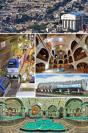
Arak ( Persian اراک; meanwhile Sultanabad ) is the capital of the Markazi province in Iran . The term Arak is the traditional name of the city and is ultimately derived from ʿErāq from the geographical term Iraq adschami ( Persian Iraq ). The city is one of the most important industrial cities in the country and has more than 2900 large, medium and small industries.
Location and geography
The current city of Arak was founded in 1808 under the name Sultanabad in the shape of a rectangle with a city wall. With over 590,000 inhabitants (as of 2016), it is the largest city in the province. The city is surrounded by mountains to the west, east and south. Arak is located about 1,750 m above sea level and is 280 km from the capital Tehran .
economy
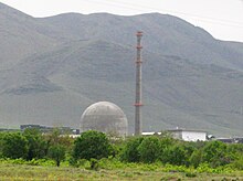
About 52 km northwest of Arak, the Iranian government is building the IR-40 , a heavy water reactor that could deliver plutonium .
traffic
The city is on the Trans-Iranian Railway . From here the railway branches off to Kermanshah , which has been open to Malayer since 2011 and is also under construction (2016).
The city has an airport .
Colleges and universities
- Arak Medical University
- Arak Technical College
- University of Arak
- Azad Islamic University of Arak
- Tarbiat Moallem University of Arak
sons and daughters of the town
- Kader Abdolah (* 1954), writer
- Mohammad Ali Araki (1894-1994), Grand Ayatollah
- Morteza Gholi Bayat (1882–1955), Prime Minister
- Mansour Bahrami (born 1956), tennis player
- Forugh Farrochzad (1934-1967), poet
- Reza Vafaei (1924–2004), educational advisor and skills developer
- Amir Kabir (1807–1852), Prime Minister, reformer
- Ataollah Mohajerani (* 1954), Deputy Minister
See also
Web links
- ARĀK . In: Ehsan Yarshater (Ed.): Encyclopædia Iranica (English, including references)
Individual evidence
- ↑ Statistical Center of Iran: Population by age groups and sex and province, the 2016 Population and Housing Census. (xlsx) Retrieved July 22, 2017 (Excel file, can be downloaded from the website. (Excel; 21 KB)).
- ^ Sunday Times: Israel is supposed to plan a nuclear strike against Iran - via SPIEGEL Online, January 7, 2007


