
Tehran
| Tehran | |||
|---|---|---|---|
.jpg) |
|||
|
|||
| Basic data | |||
| Country: |
|
||
| Province : | Tehran | ||
| Coordinates : | 35 ° 42 ' N , 51 ° 25' E | ||
| Height : | 1191 m | ||
| Area: | 716.9 km² | ||
| Residents : | 8,693,706 ( 2016 census ) | ||
| Population density: | 12,127 inhabitants per km² | ||
| Area code : | 021 | ||
| Time zone : | UTC +3: 30 | ||
| City structure: | 22 districts | ||
| Website: | www.tehran.ir | ||
| politics | |||
| Mayor : | Pirouz Hanachi | ||

Tehran ( Persian تهران, DMG Tehrān , traditionally tooطهران, DMG Ṭehrān / teɦˈrɔːn /) is the capital of Iran and the province of the same name . Almost 8.7 million people live in the administrative urban area (according to the 2016 census), the metropolitan region is estimated to have around 20 million inhabitants. However, the official statistics from 2011 only show 15.2 million people. As an industrial and commercial city with universities, colleges, libraries and museums, Tehran is an important economic, scientific and cultural center as well as an important transport hub in the country.
The name of the city
The origin of the name Tehran (actually Tehran ) cannot be clearly determined. For example, it is assumed that the name is composed of the words tah and ran , the meaning of which is aimed at the medieval, underground dwellings of the inhabitants: tah means "depth". According to another view, Tehran is derived from the old Persian teh ran , which roughly means "warm place".
The place name is derived from Iranian Muslims by folk etymology from the Semitic root ṬHR with the meaning “to be [cultically] pure” ( Arabic طَهَرَ, DMG ṭahara ' to be pure'). Wilhelm Eilers traces Tehran back to the Iranian short name čihr ("shape, origin"), which becomes čihran with the patronymic ending -an . The place name would thus be derived from the former domain of a nobleman of the same name.
The German spelling and pronunciation of the city name come from its French version. Since the h aspiré is not pronounced in French, an additional syllable has been added: The two-syllable Tehran became Téhéran .
geography
Geographical location

The city is located south of the Elbors Mountains and the Caspian Sea in the Iranian highlands, an average of 1,191 meters above sea level . 66 kilometers to the northeast is the 5604 m high Damawand volcano , the highest mountain in Iran. To the north, the slopes of the 3975 m high Tochāl mountain (with cable car ) border the urban area.
Due to the hillside location, there are considerable differences in altitude in the capital. The districts in the south border the Dascht-e Kawir salt desert and are on average 1000 meters above sea level, the city center at around 1100 to 1200 meters and the suburbs in the north at around 1700 meters.
The urban area with an area of 716.9 square kilometers extends 50 kilometers in north-south and east-west directions. The metropolitan area has an area of 18,814 square kilometers.
The rivers Karaj west of the plane and the Dschadschrud , which flows to the east of Tehran, supply the city with water. Dams were built on both rivers in the 20th century, including the Amir-Kabir Dam . Open canals run along the main streets of the capital, into which water is drawn from the surrounding mountains. Due to water consumption and the drought , the groundwater level in the city fell by twelve meters between 1984 and 2011. Since then, the situation has only got worse.

geology

Tehran is located in an earthquake-prone zone. The region in the Iranian highlands is tectonically very active. This is where the Indo-Australian and Arabian continental plates meet the Eurasian plate . Several times a year there are slight tremors. On March 27, 1830, a tremor of 7.0 points on the Richter scale shook the city. Almost all buildings in the capital were destroyed. An estimated 45,000 people died across the region.
More severe earthquakes hit the region in 300 BC. Chr. (7.6), 743 (7.2), 855 (7.1), 958 (7.7), 1177 (7.2), 1383 (7.0), 1665 (6.5) and 1815 (7.1). According to seismologists , Tehran experiences a major quake on average every 150 years. Since the last one was more than this time ago, the likelihood of a major earthquake increases in the next few years.
The inadequate earthquake safety of most buildings (including public buildings such as hospitals), the violations of building regulations through the use of cheap materials and also the inadequate earthquake planning pose a great risk for the population of the city Discussed from time to time.
The Iranian Plateau with the capital, Tehran extends 3,000 kilometers far from northwest to southeast across the dry belt of the northern trade zone , separating the African-Arab from the Turanian -zentralasiatischen desert area. Its structure is reminiscent of Asia Minor . Here as there, a highland consisting of depressions and partial basins is bordered by mountain ranges. In the north, the border is formed by the Elburs Mountains bordering the Caspian Sea, with the dormant Damawand volcano, and the garland-like train of the northern Iranian border mountains.
The interior is chambered by mountain ranges into a number of depressions and basins that have no drainage. Due to the dry climate, the weathering debris from the mountains cannot be removed due to the low flow of water in the rivers, so that the mountains “drown” in their own debris. Extensive deserts can be found in the basins, some of which have been filled with salty clays by the rivers and which turn into salt marshes in the rainy season.
City structure


Tehran is divided into 22 districts ( Persian منطقه, DMG manṭaqe ) and 120 subdistricts ( Persian ناحیه, DMG nāḥiye ). The population figures in the following table refer to the census of 1996, 2006 and 2016.
|
|
climate
The Iranian capital has a semi-arid continental climate (according to the Köppen and Geiger classification : Bsk ). It varies greatly depending on the altitude above sea level. The high north of Tehran enjoys cooler temperatures than the southern part of the city, which lies on the edge of the central Iranian desert regions.
Summers are dry and hot. The average values for July are over 30 ° C in the south of the city (around 25 ° C in the north). The winters are cold (in the north in January 2 ° C, in the south 5 ° C). It often snows in the north and west of Tehran, while the sun is shining in the south of the city.
Overall, there is little rainfall, an average of 230 millimeters per year. The mean average temperature is 16.5 ° C. In summer the temperatures rise to 40 ° C, but the summer nights are cool.
The coldest month is January. The temperatures then drop to an average value of 2.2 ° C, which statistically corresponds to the average January temperature in Cologne. The warmest month is July with an average temperature of 29.7 ° C. Most of the precipitation falls between December and April with an average of 28 to 37 millimeters, the least between June and September with an average of one to three millimeters.
| Tehran | ||||||||||||||||||||||||||||||||||||||||||||||||
|---|---|---|---|---|---|---|---|---|---|---|---|---|---|---|---|---|---|---|---|---|---|---|---|---|---|---|---|---|---|---|---|---|---|---|---|---|---|---|---|---|---|---|---|---|---|---|---|---|
| Climate diagram | ||||||||||||||||||||||||||||||||||||||||||||||||
| ||||||||||||||||||||||||||||||||||||||||||||||||
|
Climate data Tehran
station Tehran-Mehrabad (airport) / Iran, 1,204 m above sea level
Source: DWD, Regentage: reference period 1957–1993, otherwise: reference period 1961–1990
|
||||||||||||||||||||||||||||||||||||||||||||||||||||||||||||||||||||||||||||||||||||||||||||||||||||||||||||||||||||||||||||||||||||||||||||||||||||||||||||||||||||||||||||||||||||
story
origin
_003.jpg)
The first reference to Tehran - at that time still an insignificant orchard settlement near the important city of Rey - is the corresponding nisbe in the name of the scholar Abu Abdallah Muhammad ibn Hammad at-Tehrani ar-Razi, who died in 874/75 or 884/85 . The place itself, the inhabitants of which lived partly in subterranean or semi-subterranean passages and caves, was first mentioned in Ibn Balchi's Fars-nama . In this work, written between 1108 and 1116, there is (as is often the case in history) an indication of the excellent quality of the pomegranates that were grown in Tehran.
Tehran belonged to the kingdoms of the Buyids and Seljuks , to whom Rey temporarily served as a residence. In the 13th century, the place with its important market was described by Yaqut , among others , before Rey was conquered by the Mongols in 1220 and its inhabitants sought refuge in the underground settlement. The destruction of Rey at the time meant that Tehran gradually developed into a city that Mustaufi described as small but important in 1340 .
Safavids and Zand princes
Tehran only developed into a city during the Safavid government . The settlement and its citadel (later the Golestan Palace ) were surrounded by a wall under Tahmasp I (1513–1576). Tahmasp was crowned second Shah of the Safavid dynasty in 1524 at the age of only ten as the successor to his father, Ismail I (1501-1524).
Under Abbas I (1571–1629), who temporarily resided in Tehran, wide streets and avenues were built. Also Karim Khan (1705-1779), founder of the short-lived dynasty of the Zand-Prince , took the city temporarily as a residence. He had a palace built and the city wall reinforced because of the threat posed by the Qajars . Despite military successes against the Qajars - he killed their leader Mohammed Hassan Khan and took his son Agha Mohammed Khan (1742–1797) hostage - he moved his residence back to Shiraz for security reasons .
Qajars

Despite the ramparts under the Safavids and Zand princes, Tehran initially remained a provincial city. This changed suddenly with the death of Karim Khan in 1779. Aga Mohammad Khan was now able to free himself from captivity and, with the help of the Qajars, take over power.
In 1788 he captured the last ruler of the Zand dynasty , Lotf Ali Khan (1769–1794), and killed him. A year later he moved his residence to Tehran. There he was crowned Shah in the spring of 1796 , thus establishing the Qajar dynasty. Around the year 1800 there were around 15,000 inhabitants.
Under his successor Fath Ali (1762–1834) numerous mosques, madrasas and palaces were built, including the Golestan Palace . The fortification wall around the city has also been partially restored. The Qajar ruler Nāser ad-Din Shāh (1831-1896) enlarged the original urban area by five times during his reign. He had the old city wall torn down and replaced by a new one with magnificent city gates. In 1883 there were over 100,000 inhabitants. This made Tehran the largest city in Persia , also due to the strong centralization of the country.
Pahlavis

Under Reza Shah Pahlavi , the city was enlarged again in the 1930s, a continuous road built across the city and the old Qajar settlements leveled. The old fortification wall was torn down and a new geometric road network was built. The Trans-Iranian Railway connected Tehran with the Caspian Sea and the Persian Gulf.
After British and Soviet troops jointly occupied Iran in 1941 and helped Mohammad Reza Pahlavi to power there , the supply route to the Soviet Union , known as the Persian Corridor , was opened and in 1942 also made it possible for the exiled Polish Anders Army to move to Iran. In the course of this transfer, many Polish orphans came to Iran, for whom a camp had been set up in Tehran in 1942. After the Jewish Agency for Israel learned that there were many Jewish children among these orphans, it set up a camp for them with the support of the Tehran Jewish community. In August 1942, 612 children, 100 of whom were ten years old or younger, lived in this camp, which became known as the Jewish orphanage and which later housed the so-called Tehran children . 80 more children were added over the course of the next month. At the beginning of 1943, the children of the camp were able to travel by sea and land to Palestine, where they reached the Atlit refugee camp in northern Palestine on February 18, 1943 . The Tehran children were the largest group of Holocaust survivors to arrive in Palestine during World War II.
The Tehran Conference of Churchill , Roosevelt and Stalin from November 28 to December 1, 1943 was important. The main topic was the agreement on how to proceed in the European theater of war in 1944 and the time after a victory of the Allies in World War II .
In the 1960s and 1970s, the road network was expanded during the government of Shah Mohammad Reza Pahlavi. The permanent achievements of the Shah include the settlement of industry and the creation of a modern infrastructure .
The population growth was enormous due to rural exodus and a high birth rate . In 1966 there were 2.7 million people in Tehran. In 1976 a census already showed 4.5 million inhabitants.
Islamic Republic

In 1978 unrest broke out in Tehran in the run-up to the Islamic Revolution , which finally ended with the overthrow of the Shah, whereupon Ruhollah Khomeini (1902–1989) returned in February 1979 and proclaimed the Islamic Republic of Iran. As a result, was Embassy of the United States occupied ( kidnapping of Tehran ).
During the First Gulf War (1980–1988), Tehran was a target for Iraqi air and missile attacks. On September 22, 1980, the Iraqi air force bombed the capital for the first time. In 1985 the so-called “city war” began. Tehran was hit several times by ballistic missiles from Iraq. Most of the victims who died in the attacks were civilians.
On October 21, 1996, Tehran had a population of 6.8 million in the census. According to an official estimate by the “Statistical Center of Iran”, 7.1 million people lived in the capital on July 1, 2004.
After the severe earthquake in Bam in 2004, consideration was given to relocating the seat of government from Tehran to a region that was less prone to earthquakes. However, it was decided to make the city more earthquake-proof through structural measures instead of relocating the seat of government.
On June 7, 2017, Tehran was the target of a double attack with 18 dead.
Population development

The population of Tehran has grown rapidly. In 1800 only 15,000 people lived in the city, so in 1883 the population of the city already exceeded the limit of 100,000, making it a major city . By 1956 it rose to 1.5 million and by 2006 - due to the incorporation of numerous suburbs and the influx of migrants from the surrounding area - to 7.8 million. According to calculations, just under 8.8 million were registered in 2012. The population density in the city is 10,877 people per square kilometer. In 2006, 13.4 million people lived in the metropolitan region (2006 census) and in 2012, according to calculations, more than 15.1 million. The population density is 713 inhabitants per square kilometer.
The following overview shows the number of inhabitants according to the respective territorial status. These are estimates up to 1870 and census results from 1883 to 2006 . The population figures refer to the actual city without the suburbs.
|
|
Development of the living situation

According to the “global plan for Tehran”, a high-rise district was to be built as the new financial and business center of Iran and the Middle East in the Abbasabad area during the government of Shah Mohammad Reza Pahlavi . This plan was abandoned after the Islamic Revolution of 1979. Some of these plots ( Araazie nosazie abbasabad in German, ' Plots to build Abbasabads') are still fallow or are only slowly being built on. Shahrak-e Gharb in the northwest of the city is the only part of this plan that was realized before the revolution . This and the Ekbātān high-rise complex in the west are to this day the only districts of Tehran that were planned and built according to modern urbanistic theories.
After the revolution, the rural exodus to Tehran continued and was intensified by the refugees of the First Gulf War from the war regions in the west and south-west of Iran. In addition, there were hundreds of thousands of Afghan refugees who sought refuge and work in Tehran after the outbreak of civil war in Afghanistan . These developments and the complete lack of state housing and larger private housing associations led to a housing shortage and an astronomical rise in the price of living space, which continues to this day.

The housing shortage in the city, the high rents and the real estate prices led to an explosive population increase in the lower-priced suburbs of Tehran. In this way, small villages turned into large cities within a few years without any urban infrastructure or supply facilities. Examples of this development are the cities of Eslam-Shahr in the southwest, Varamin in the southeast and Shahr-e Ghods in the west of the city. The city of Karaj, 25 kilometers to the west, and its surroundings now have around three million inhabitants. Karaj is often referred to as the largest dormitory city in the world.
In the 1990s, new parks and green spaces were built. Due to massive housing construction by property speculators in the posh districts of northern Tehran, however, many gardens and villas have been destroyed. These luxury apartments have little impact on the housing situation of the urban population because only a few can afford these apartments. In addition, many of these apartments have been vacant for years because many owners are not even interested in living in or renting out, but are speculating on a higher resale value.
In a ranking of cities according to their quality of life, Tehran was in 200th place out of 231 cities worldwide in 2018.

politics
City government
Mayor of Tehran is Piruz Hanatschi, English transcribed Pirouz Hanachi ( Persian پیروز حناچی, DMG Pīrūz Ḥanāčī ). Previously, in 2005, Mohammad Bagher Ghalibaf took over from Mahmoud Ahmadineschad , who had ruled the city since 2003. In the city council elections on February 28, 2003, the second since 1999, Ahmadinejad was elected mayor of the capital Tehran with an extremely low turnout (twelve percent). He resigned from office to run for the 2005 presidential election. He was the sixth President of the Islamic Republic of Iran from August 3, 2005 to August 3, 2013. His successor in this office is Hassan Rohani .
The “Islamic City Council of Tehran” consists of 15 members. He has the task of confirming the elected mayor and approving the budget . Until 2006, all members belonged to the 'Coalition of the Builders of Islamic Iran' ( Etelaf-e Abadgaran-e Iran-e islami ). Politically, President Mahmud Ahmadinejad is assigned to this group.
In the local elections on December 15, 2006, an unusually high voter turnout of around 60 percent was achieved, which ended the trend of recent years. The result was a defeat for the radical Islamists around President Ahmadinejad, despite the candidate selection by the Guardian Council . In Tehran's city council, the candidates from the presidential camp with two representatives fared significantly worse than the conservatives and the reformers. The technocrats around Ghalibaf got eight seats. The reformers formed the second largest group with four seats. One seat went to an independent candidate close to the moderate technocrats.
Well-known personalities such as Mohammad-Ali Najafi (former vice-president under Mohammad Chātami and education minister under Akbar Hāschemi Rafsanjāni ), Ahmed Masjed Jamei (former culture minister and advisor under Khatami), Masoumeh Ebtekar (former vice-president under Khātami and student of the Iranian people) were elected to the city council during the hostage-taking of Tehran ), Hadi Saei Bonehkohal (Olympic champion in Taekwondo at the 2004 Summer Olympics ), Rasoul Khadem (Olympic wrestling champion at the 1996 Summer Olympics ) and Alireza Dabir (Olympic wrestling champion at the 2000 Summer Olympics ). Parvin Ahmadineschad, sister of President Mahmud Ahmadineschad, won a seat on the city council for the list called "The Sweet Scent of Service".
The following fifteen candidates were elected to the Tehran City Council in 2006:
| rank | Surname | fraction | voices | percent |
|---|---|---|---|---|
| 1 | Mehdi Tschamran | Ghalibaf | 603.766 | 36.45 |
| 2 | Morteza Talaei | Ghalibaf | 539.761 | 32.58 |
| 3 | Rasoul Khadem | Ghalibaf | 427.097 | 25.78 |
| 4th | Abbas Scheibani | Ghalibaf | 394.457 | 23.81 |
| 5 | Hadi Saei Bonehkohal | reformer | 384.358 | 23.20 |
| 6th | Hamzeh Shakib | Ghalibaf | 330.233 | 19.93 |
| 7th | Alireza Dabir | More independent | 306.729 | 18.52 |
| 8th | Parvin Ahmadinejad | Ahmadinejad | 242.501 | 14.64 |
| 9 | Masoumeh Ebtekar | reformer | 232,959 | 14.06 |
| 10 | Ahmed Masjed Jamei | reformer | 216.015 | 13.04 |
| 11 | Mohammad-Ali Najafi | reformer | 202,700 | 12.24 |
| 12th | Masoume Abad | Ghalibaf | 201,754 | 12.18 |
| 13 | Hassan Bayadi | Ghalibaf | 200,397 | 12.10 |
| 14th | Khosrov Daneschdschu | Ahmadinejad | 200,175 | 12.08 |
| 15th | Habib Kashani | Ghalibaf | 197.284 | 11.91 |
Town twinning
Tehran has partnerships with the following cities. The year of establishment is shown in brackets.
-
 Seoul , South Korea (1963)
 -
 Los Angeles , United States (1972)
 -
 London , United Kingdom (1993)
 -
 Havana , Cuba (2001)
 -
 Pretoria , South Africa (2002)
 -
 Moscow , Russia (2004)
 -
 Caracas , Venezuela (2005)
 -
 Dushanbe , Tajikistan (2006)
 -
 Minsk , Belarus (2006)
 -
 Beijing , People's Republic of China (2006)
 -
 Dubai , United Arab Emirates (2012)
 -
 Ankara , Turkey (2013)
 -
 Tbilisi , Georgia (2015)
 -
 Budapest , Hungary (2015)
Culture and sights
Religions

96 percent of Tehran's 8.2 million population (2016) are Muslims . The Twelver Shiite Islam is since 1501 the state religion . The largest religious minority are the around 200,000 disenfranchised Baha'i (2.8 percent) in Tehran (see also: Persecution of the Baha'i ). There are also Oriental Christians , but their number fell sharply after the 1979 revolution.

The largest Christian community in Tehran is made up of around 60,000 Armenians (0.8 percent) who traditionally live in the Vanak , Majidijeh and Haft-e Tir districts. The majority of them belong to the Armenian Apostolic Church , but there are also Armenian Catholics and members of the Armenian Evangelical Church . The Armenian minority maintains numerous cultural and sports facilities in the city, including the famous Ararat sports complex and numerous libraries as well as the Armenian elementary, middle and high schools Nevart Gulbenkian, Alischan, Maryam and Marie Manoukian. In addition, the Armenian Apostolic Diocese, which has its seat in the Saint Sarkis Cathedral and is responsible for the faithful in the central part of Iran around Tehran, has 42 churches. The Armenian Apostolic Archbishop of Tehran Sepuh Sargsyan gave the number of Armenian churches in the capital at eleven in November 2016. The oldest churches in Tehran are the Armenian Church of St. Thaddäus and Bartholomäus near the Grand Bazaar from 1768 and the Armenian Church of Saint George (Surp Kevork) on Shahpur Street (Ghnemiyeh) from 1795. More recent are the 1854 built Saint Minas Church in the Vanak district, the Church of Our Lady from 1945 and Saint Sarkis Cathedral, completed in 1970. The Armenian Catholic Church of Saint Gregory the Illuminator (Surp Grigor Lusavoritsch ) on Ghazali Street was built in 1955, the Church of Joseph on Mirdamad Boulevard in 1963.
Of the Christian Assyrians , around 10,000 members of the Assyrian Church of the East (0.1 percent) with the Cathedral of St. George (Mar Gevargiz) from 1961 and St. Mary's (Mart Maryam, Sarbaz Street) from 1978 and 5000 Chaldean live in Tehran Catholics (0.05 percent) with their St. Josef (Mar Yozef) cathedral from 1950, both of which can be assigned to the East Syrian rite and also maintain other churches in the city. There are also numerous smaller Christian communities, such as the Georgian Orthodox and Russian Orthodox Churches , as well as numerous Protestant communities such as the Anglican Church of Persia, the Evangelical Presbyterian Church in Iran or the Pentecostal Church of Jama'at-e Rabbani . Finally, there are also diaspora congregations such as the German-speaking Protestant congregation in the Christ Church .
The Jewish community has around 18,000 members (0.2 percent). There are around 25 active synagogues in Tehran today. Like the Armenians, the Jewish community also maintains numerous libraries and schools in which Hebrew is taught. The most famous Jewish school Rāh-e Dānesch is now an all- girls school and is one of the most renowned Jewish schools in the entire Middle East outside of Israel.
Another important religious minority are the around 10,000 Zoroastrians (0.1 percent) who traditionally live in the Qolhak districts and the surrounding area. They also maintain their cultural associations and have two fire temples (Aatashkadeh).
theatre
The largest theater in the city is the Vahdat concert hall with almost 1,000 seats. Today's Talar-e Vahdat was built in 1967 as the Rudaki-Halle Opera House (home of the Rudaki Orchestra), other theaters are the Nasr (the oldest in the city) and the Parstheater.
The Fajr Theater Festival has been held in Tehran every January since 1983. It was originally founded in honor of the revolutionary leader Ayatollah Ruhollah Khomeini and replaced the music and theater festival in Shiraz . The Fajr (Dawn) lasts ten days, as long as it took Khomeini to take power in Iran after his return from exile. He returned from Paris to Tehran on February 1, 1979, and on February 11, the government of the Shah, who had fled on January 16, 1979, was overthrown. International artists have also been taking part in this major theater festival since 1999.
Museums

Important museums in the capital include the Museum of Contemporary Art , the Archaeological Museum, the Abgineh Museum with an exhibition of Iranian pottery, the Reza Abbasi Museum with a collection of Iranian calligraphy and paintings, and the Rassam Carpet Culture and Art Collection with a carpet weaving school. Other museums include the National Museum (Iran Bastan Museum) with archaeological artifacts from the pre-Islamic period of Iran, the Anthropological Museum, the Natural History Museum, the Museum of Islamic Art and the Museum of Glass and Ceramics with treasures made of enamel , crystal, mother-of-pearl , gold and Lapis lazuli .
Large quantities of jewelry and precious stones are kept in the Crown Jewels Museum in the National Bank, including the sun throne adorned with gold and precious stones, the Darja-ye Nur diamond (sea of light) with 182 carats and the jeweled globe with a 51,363 precious stones Weight of 36.5 kilograms of fine gold. The collection also includes the crown of Reza Shah Pahlavi from 1924 with almost 4,000 precious stones and a total weight of 2.080 kilograms, the crown of the former Empress Farah Pahlavi and the headdress of Nadir Shah (1688–1747), consisting of a large emerald in the center and a crescent moon of 781 carats diamonds.

The historical complex Zendān-e Qasr is a former prison.

The Museum of Contemporary Art in Tehran
.jpg)

Buildings


There are numerous buildings worth seeing in Tehran. Some date from the Qajar era , including the Golestan Palace , the former government palace (seat of the Shah until 1979) and the Shah Mosque. The Golestan Palace was built at the end of the 18th / beginning of the 19th century. Today the building houses a museum in which ceramics, jewelry and weapons are shown. The most famous exhibit is the peacock throne .
The Imam Khomeini Mosque is located near the bazaar and the Golestan Palace. The visitor enters the courtyard with the four entrance portals through four narrow passages. The mosque was built at the instigation of the Qajar ruler Fath Ali at the beginning of the 19th century. The arcades and the gables are decorated with yellow-ground glazed tiles . The main prayer room, which is open to the courtyard, is spanned by a blue dome.
On Meidan-e Baharestan (Spring Square) is the Masjed-e Shahid Mottahari, which was completed under the Qajar ruler Nasir-ud-Din Shah in 1830 and was called the Sepahsalar Mosque until the Islamic Revolution in 1979. The largest mosque in the capital, at 3700 square meters, is surrounded by two rows of arcades, one on top of the other, and the prayer halls with stucco ornamentation openly face the courtyard. There is a theological faculty in the complex where seminars are held.
One of the most famous modern buildings in Tehran is the 45-meter-high Freedom Tower (Iranian: Azadi), which was built in 1971 on the road from Mehrabad Airport to the city on the occasion of the 2500th anniversary of the Iranian monarchy from over 25,000 white stones broken in Isfahan . A lift takes you to a viewing platform on the tower, which offers a wide view of the city. Most of the time, the snow-covered mountains of the Elbursgebirge can also be seen here. Today the tower is considered a symbol of modern Tehran.
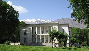
Also worth mentioning is the Saadabad palace complex in northern Tehran, a summer residence of the last Shah. In the area with an area of 410 hectares there are several palaces. The largest building is the White Palace, formerly the ceremonial and reception palace of Reza Shah Pahlavi (1878–1944) and his son Mohammad Reza Pahlavi (1919–1980). Other buildings are the Palace of the Mother of the Shah, the Palace of the Crown Prince, the Black Palace and the Green Palace, the oldest and most architecturally most important building in the entire complex.
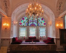
The Niavaran palace complex in northeast Tehran is another summer residence of the former Shah of Iran. On a park-like area of around eleven hectares in the affluent Niavaran district, there are more than 20 buildings, including the Sahebqaraniyeh Palace from the Qajar era, which was built in 1870 . The Pahlavi family stayed in the Niavaran palace complex for much of their time. Several buildings have been opened to visitors since 2000.
The sites of the tomb of Imam Khomeini and the cemetery of southern Tehran Behescht-e Zahra with the blood well are considered symbols of the Islamic Republic . The mausoleum in the south of Tehran has four towers, each 91 meters high. The height of 91 meters was chosen according to the age of Khomeini when he died in 1989. As a result, he would have been born in 1898, or the Islamic lunar calendar , in which the year is eleven days shorter than the solar calendar, was used to calculate his age.
The tallest structure in Iran is the 435-meter-high Borj-e Milad television tower in the Gischā district of Tehran , which was completed in 2007 . It is the sixth tallest television tower in the world .

Shams-ol-Emareh - Golestan Palace
Saadabad Palace Complex : White Palace
Niavaran Palace Complex : One Hall


Parks

Basically, it is time-consuming to create green areas in the high altitude and dry areas of Tehran. So it took a long time to create public parks the size of a megacity. For example, Park-e Schahr, which is designated as the “Central Park ”, is only 26 hectares in size. Even today, huge residential areas are almost completely devoid of green, and you have to walk for a long time to reach one of the larger complexes. In the meantime, the city administration has recognized the value of public green spaces and parks, especially in the fast growing north of the city.
In Tehran there are around 800 mostly small and very small parks. Well-known parks are Daneschdschu Park, Sa'ei Park and Schatrandsch Park. One of the largest is Mellat Park , which was called Shahanshahi Park ( Park of the Empire ) until the Iranian Revolution in 1979 . It is bordered by Valiasr Road to the east and Parkway (Chamran) and Seoul Road to the west.
Laleh Park is located in the city center, north of Tehran University . To the east of the park is the Ministry of Agriculture, to the northwest the Carpet Museum and to the west the Museum of Contemporary Art. There are many coffee shops, fast food restaurants, shopping malls and designer stores nearby .

In the Niavaran district lies the Jamschidieh Park , named after the Qajar prince Jamschid Davallu Kajar, to whom the Iranian Empress Farah Pahlavi dedicated the park. In the park at the foot of the Kolakchal Mountain there are numerous restaurants, teahouses, picnic areas and an open-air amphitheater. Another park in Niavaran is Niavaran Park , located south of the palace .
Schahr-e Bazi (formerly Luna Park) is the name of Tehran's largest amusement park . It is located in the north of the city near the Chamran highway and the front of the Evin district.
Chitgar Park is located directly on the city limits to District 22, in the province of Tehran . At 14.5 square kilometers, it is one of the largest parks in the province. You can go cycling and ice skating there. The Kan and Vardavard rivers flow through the man-made forest. The plan is to create an artificial lake between the Chitgar hills. The park can be reached via the country road and by subway .
Sports

Tehran was the first city in the Middle East to host the Asian Games in 1974 . 2,363 athletes from 25 countries took part.
The Azadi sports complex with a capacity of 110,000 spectators, the largest stadium in Tehran. It used to be known as "Aryamehr". The latter name, a title of the Emperor Shah Mohammad Reza Pahlavi , during whose reign the complex was built, was changed after the 1979 revolution. The Iranian national soccer team plays their most important international matches there. This is also where the games of Persepolis and Esteghlal in the top football league ( Iranian Pro League ) take place.
The most successful football club is Persepolis. The club is the record champions in Iran with eight titles. Other clubs are Pas (the venue is the Shahid Dastgerdi Stadium), Rah Ahan (plays in the Derachshan Stadium), Saba Battery (the venue is the Derachshan Stadium) and Saipa (plays in the Enghelab Stadium).
Because of the high temperatures and air pollution, outdoor sports are very strenuous. Badminton, tennis and golf are mostly played, but roller skating is also popular. The most important sports also include wrestling and weightlifting. Tehran hosted the World Wrestling Championships in 1959, 1973, 1998 and 2002. Numerous horse races and polo games also take place in Tehran .
Outside the city, water and winter sports can also be practiced. The ski areas around 30–50 kilometers north of Tehran are very popular. In the Elburs mountain ranges north of Tehran there are countless ski slopes at altitudes of 2500–3000 meters with ideal conditions and facilities at affordable prices, such as Dizin . The ski area near Totschāl is considered the fourth highest ski region in the world.
shop

The bazaar of Tehran is worth seeing . With an alley length of almost ten kilometers and over 10,000 shops, it is the largest covered bazaar in the world. In the small shops the visitor is offered a large selection of goods, from precious carpets to silver and copper work to food and exotic spices.
Separate areas have been set up on the market for the various trades. There you can watch the craftsmen at work. The bazaar is open every day except Friday and religious holidays. The bazaar was laid out in the Qajar era. Another large bazaar is located in the suburb of Tajrish , in northern Tehran.
In 2020 the shopping center "IRAN MALL" (English), Persian, opened in the northwest of Tehran بازار بزرگ ايران, DMG Bāzār-e bozorg-e Īrān , 'Great Market of Iran'. The Iran Mall is the largest shopping center in the world in relation to the total built-up area of 1.95 million m².
Economy and Infrastructure
business
Greater Tehran is the country's largest industrial and commercial center, where 65 percent of all industrial products in Iran are produced. In the industrial plants of the Iranian capital, among other things, cotton textiles, food, cement and bricks are produced. Other important economic sectors are petrochemicals, electricity generation and distribution, traffic engineering and the automotive industry, aluminum and steel industry, and water and wastewater management.
The National Iranian Oil Company in the capital manages the crude oil industry, which is concentrated in Abadan and other regions of the country. Most of the economy is under state control. Only small businesses are privately owned. The Research Institute of Petroleum Industry is significantly involved in the research .
The Iranian capital is the seat of the Tehran Stock Exchange (TSE), founded in 1967 . A second exchange, the Iranian Oil Exchange , based on the island of Kish in the Persian Gulf , opened on February 17, 2008. The operating company is the "International Iran Oil Bourse Company", which is majority owned by the Oil Industry Pension Fund in Tehran.
Problems are caused by heavy air pollution, around 80% of which was caused by traffic as of 2016, as well as by house fires in winter and industrial emissions. In 2016 there were around 3.5 million vehicles in the city, many of them from the state-owned production of the Iran-Khodro Group, some of which use more than twice as much fuel compared to modern foreign cars.
The scarcity of water and the lack of parks and wooded areas in the area exacerbate the ecological problems. There is also an above-average pollution of drinking water with pollutants. One consequence of this is an increase in asthma and cardiovascular diseases as well as allergies among the residents of Tehran. The environmental pollution in the capital is one of the highest in the world.
traffic
Long-distance transport

With the two airports Mehrabad International Airport (THR) and the Imam Khomeini International Airport (IKA), which opened on May 8, 2004, Tehran has connections to international air traffic.
The airport Mehrabad is located five kilometers west of Tehran's center. Travel time to the city is 45 minutes by airport bus and 30 minutes by taxi. The Imam Khomeini International Airport is located 30 kilometers south of Tehran. The travel time to the city is around an hour and 30 minutes by bus and around an hour by taxi. Air travel within the country is very convenient and also very cheap. Tickets have to be booked well in advance as the flights are often full.
There is a connection to Europe with intercity buses. From the Istanbul bus station Esenler buses run daily up to Tehran. The excellent motorway network of Iran with roads of Central European standard is centralized on Tehran.
The Tehran main station is by the Islamic Republic of Iran Railways operated. All major cities in the country can be reached by long-distance trains, including Mashhad , Ahwas , Tabriz , Qom , Khorramshahr and Isfahan . The only international connection is a pair of trains to Istanbul .
In May 2008 it was announced that Iran would build a Transrapid from Tehran to the eastern pilgrimage town of Mashad, 850 km away. Iran hopes to reduce the current travel times of 2.5 days by bus to up to two hours.
In 2005 there were an average of three traffic fatalities per hour in Iran, that is around 27,000 per year. This put the country in first place in international statistics.
Local transport, city highways


The traffic situation, especially in the city center, has been very tense for some time. The increased number of inhabitants has resulted in an everyday traffic blackout. The main reason for this is the lack of an efficient local public transport system. A large part of the population is still dependent on the use of buses and taxis.
The first buses drove in the Iranian capital in 1927. In total, more than 5,000 buses of various types operate on around 250 main routes and around 100 express routes. The bus system carries the main load in local public transport. The roughly 4,000 minibuses serve over 100 lines and connect the outskirts and suburbs with the city center. The insufficient supply is offset by a great demand for transport options. That is why bus passengers also use taxis: a total of around 30,000 drive on the streets of Tehran.
The Tehran trolleybus has been operating in the city since 1992; it is the only trolleybus operation in Iran. The originally 17.1 kilometer long route network was at times served by up to five lines, today there is only one line on an approximately two kilometer long section.
Tehran is the best city in Western Asia with inner-city highways and expressways. They run through all parts of the city, albeit often at greater distances from the traditional residential areas. Wherever possible, embankments, crosses and driveways are lavishly greened. In many places, pedestrian bridges ensure that residents can get to the bus stops without any major detours.
On March 7, 1999, the first line (line 5 - Tehran-Karadsch-Mehrschahr-Schnellbahn) of the subway in Tehran was opened. Sections of Line 2 followed on February 21, 2000, and part of Line 1 was also put into operation on August 28, 2001. The three lines are operated by the "Tehran Urban & Suburban Railway Company".
media
Tehran is the country's media center. The most important daily newspapers appear here ( Dschomhuri-ye Eslami , Resalat , Keyhan , Achbar , Ettelā'āt ), including some English-language newspapers ( Tehran Times , Kayhan International , Iran Daily , Iran News ).
The daily newspaper Hamshahri ("The Fellow Citizen") published in Tehran is the most widely read newspaper in the country. It was founded in 1992 by the former mayor Gholamhossein Karbastschi and is published by the city's magistrate. The readership is predominantly supporters of the progressively oriented "Party of the Servants of Construction".
Keyhan ("Die Welt") is the daily newspaper with the second highest circulation. The Kayhan Society is the publisher of the newspaper, which has been published since 1943. Through its connection to the international news agencies AFP , AP and Reuters , it is largely independent of the state Iranian news agency IRNA . The readers are rather conservative and areclose tothe revolutionary leader Seyyed Ali Chāmene'i .
The daily newspaper "Iran", headquartered in Tehran, is one of the ten most widely read newspapers and is the only state-financed daily newspaper in the country. The publisher is the Iranian news agency IRNA. The readership can be assigned to the political camp of reformers around the former President Mohammad Chātami .
The literary and art magazine Nafeh has been published in Tehran since 1998 .
The newspapers, but also the state radio and television stations, are subject to state censorship . In addition, there are over 30 Iranian television channels from the San Fernando Valley, California , near Los Angeles , which can be received in Tehran via satellite or the Internet. These channels, which cannot be reached by the Iranian censors, played an important role in coordinating the demonstrations during the student protests in 2003.
education

The numerous universities in Tehran include: Allameh Tabatabai University, Amirkabir University of Technology, Alzahra University , Bagher Aloloum University, Baghiatollah University, Baqiyatallah Medical Science University, Comprehensive University of Technology, Imam Ali- Army Officers University , Imam Hossein University , Imam Sadegh University, Institute for Studies in Theoretical Physics and Mathematics (IPM), International University of Iran, Iran University of Medical Sciences , Iran University of Science and Technology (IUST), Azad Islamic University and KN Tusi University of Technology .
Other important universities are: Medical University for the Army of the Islamic Republic of Iran, NAJA University of Police, Payame Noor University , Shahed University, Shahid Beheschti University , Shahid Beheschti University of Medical Sciences and Health Services , Shahid Sattari Aviation Engineering University, Sharif University of Technology , Tarbiat Moallem University, Tarbiat Modares University, Tehran University of Applied Sciences and Technology, Tehran University of Medical Sciences, Tehran University of Tarbiat Moallem, Tehran University , Emam-Reza -University, University of Islamic Sects, University of Social Welfare and Rehabilitation Sciences, Kharazmi University, as well as the University of Arts.
sons and daughters of the town
Tehran is the birthplace of numerous prominent personalities.
See also
literature
- Peter Georg Ahrens: The development of the city of Tehran. Leske, Opladen 1966, OCLC 6004240 .
- Ralf Burnicki, Maryam Sharif: The street cleaners of Tehran. Lyrics from Iran , Edition Av, Frankfurt 2004, ISBN 3-936049-41-6 .
- Cornel Braun: Tehran, Marrakech and Madrid. Your water supply with the help of qanats. Dümmler, Bonn 1974, ISBN 3-427-75521-5 .
- Sonia Seddighi, Betty Mahmoody (ed.): Betty Mahmoody, an American in Tehran. Das Arabisches Buch, Berlin 1995, ISBN 3-923446-80-2 .
- Martin Seger : Tehran. An urban geographic study. Springer-Verlag GmbH, 1982, ISBN 3-211-81368-3 .
- Manfred Stammel: The Perception of Prosperity and Poverty. Spiritual historical development and indigenous cognition using the example of an extended family group in Tehran. wvb Wissenschaftlicher Verlag, Berlin 2005, ISBN 3-86573-064-7 .
Web links
- Literature from and about Tehran in the catalog of the German National Library
- Tehran . In: Ehsan Yarshater (Ed.): Encyclopædia Iranica . (English, iranicaonline.org - including references).
- Link catalog on the subject of Tehran (English) at curlie.org (formerly DMOZ )
- Islamic City Council of Tehran (Persian)
- Geographical Information Center of the City of Tehran ( Memento from January 23, 2007 in the Internet Archive ) (Persian, English); in the Internet Archive
- German Embassy School Tehran
Individual evidence
- ^ Statistical Center of Iran: Tehran City. Retrieved September 20, 2017 .
- ↑ Official demographic statistics 2011 .
- ↑ See transliteration .
- ↑ See H. Wehr: Arabic Dictionary , Wiesbaden 1968, p. 515.
- ^ Wilhelm Eilers: Geographical naming in and around Iran. An overview in examples. Bavarian Academy of Sciences. Meeting reports, year 1982, issue 5, CH Beck, Munich 1982, p. 12.
- ↑ Why Tehran is falling dangerously. In: gfz-potsdam.de . December 7, 2018, accessed December 19, 2018 .
- ↑ Mahmud Haghshenas Haghighi, Mahdi Motagh: Ground surface response to continuous compaction of aquifer system in Tehran, Iran: Results from a long-term multi-sensor InSAR analysis. In: Remote Sensing of Environment. 221, 2019, p. 534, doi: 10.1016 / j.rse.2018.11.003 .
- ↑ Mohammad Ashtari Jafari, Dennis Hatzfeld, Nasrollah Kamalian: Microseismicity in the region of Tehran . In: Tectonophysics . tape 395 , no. 3-4 , January 2005, pp. 193-208 , doi : 10.1016 / j.tecto.2004.09.011 (English).
- ↑ Rudolph Chimelli: Iran is considering relocating the capital to an earthquake-poor area. In: Süddeutsche.de . May 11, 2010, accessed October 16, 2016 .
- ↑ Iran: Tehran City. In: citypopulation.de. Retrieved November 5, 2019 .
- ↑ worldweather.org
- ^ German Weather Service: Climate Information Tehran. (PDF) German Weather Service, accessed on June 18, 2021 .
- ^ Dvora Hacohen: To Repair a Broken World. The Life of Henrietta Szold, Founder of Hadassah , Havard University Press, Cambridge, Massachusetts & London 1921, ISBN 978-0-674-25918-8 (pdf edition), p. 308
- ↑ USHMM Holocaust Encyclopedia: Tehran Children
- ↑ Yad Vashem -Online: The “Tehran Children” arrive in Eretz Israel , February 1943
- ↑ Tehran 1877 - map from kk Major August Krziž - from the Austrian Academy of Sciences - Woldan Collection
- ↑ Mercer's 2018 Quality of Living Rankings. Retrieved August 18, 2018 .
- ^ The Washington Institute for Near East Policy: Iran's Municipal Elections: A Turning Point for the Reform Movement? .
- ↑ Middle-east-online: Ahmadinejad Tehran defeat confirmed , December 21, 2006.
- ↑ Iran Daily - Front Page - 12/23/06. See section: Winners of Tehran City Council Vote . (No longer available online.) In: iran-daily.com. Archived from the original on September 3, 2007 ; accessed on January 11, 2020 (English).
- ↑ a b c d Eliz Sanasarian: Religious Minorities in Iran. Cambridge University Press, Cambridge 2000, ISBN 0-521-77073-4 .
- ↑ «Գանձասար» -ի հարցազրոյցը ՝ Թեհրանի հայոց թեմի առաջնորդ Տ. Սեպուհ արք. Սարգսեանի հետ [ Gandzasar's interview with Archbishop Sepuh Sargsyan]. Ալիք ( Alik ) November 5, 2016.
- ↑ Yadman Sazeh Company: Official website ( Memento of the original from October 4, 2006 in the Internet Archive ) Info: The archive link was inserted automatically and has not yet been checked. Please check the original and archive link according to the instructions and then remove this notice.
- ↑ See Persian Wikipedia article .
- ↑ Largest malls worldwide, by GLA 2020. Accessed on July 6, 2021 (English).
- ↑ Die Zeit: Lexicon Iran ( Memento from October 23, 2007 in the Internet Archive )
- ↑ Oil course opens in Iran's Kish Island. (No longer available online.) In: presstv.com. February 17, 2008, archived from the original on February 2, 2009 ; accessed on April 21, 2019 .
- ↑ Plans for Iran's Oil Exchange with no discernible progress. (Not available online.) In: bfai.de . July 23, 2007, archived from the original on March 6, 2008 ; accessed on May 4, 2020 .
- ↑ Tehran is suffocating in smog. In: dw.com. November 17, 2016, accessed October 15, 2020 .
- ↑ Iran's car production rises to a record level. (No longer available online.) In: bfai.de. Federal Agency for Foreign Trade , archived from the original on March 6, 2008 ; accessed on November 7, 2019 .
- ↑ Freidoun Gharib: Public transport in Tehran . In: TU international - magazine for international graduates of the Technical University of Berlin . No. 54 . TU Berlin, August 2003, ISSN 0935-2740 , p. 26–30 ( full text ( memento of November 27, 2005 in the Internet Archive ) [PDF; 344 kB ; accessed on November 10, 2020]).