
Amir Kabir Dam
| Amir Kabir Dam | |||||||
|---|---|---|---|---|---|---|---|
 |
|||||||
|
|||||||
|
|||||||
| Coordinates | 35 ° 57 '20 " N , 51 ° 5' 30" E | ||||||
| Data on the structure | |||||||
| Construction time: | 1957–1961/1962 | ||||||
| Height of the barrier structure : | 180 m | ||||||
| Building volume: | 0.75 million m³ | ||||||
| Crown length: | 390 (or 417?) M | ||||||
| Power plant output: | 90 MW | ||||||
| Data on the reservoir | |||||||
| Water surface | 40 km² | ||||||
| Storage space | 205 million m³ | ||||||

The Amir Kabir Dam ( Persian سد امیرکبیرThat) as Sadd-e Karaj is known, is a large dam on the river Karaj (Karaj) in Iran northwest of Tehran . It is named after the former Iranian Prime Minister Amir Kabir .
Construction
The dam's arch dam is 180 m high and doubly curved. The first considerations about the construction of the dam date back to the time of Reza Shah Pahlavi . However, it would take until 1952 before the first concrete plans were tackled. The first plans were drawn up as part of the Point IV program .
In 1956, the approval process was initiated and construction work began by the American company Morrison-Knudsen . Morrison-Knudsen was one of the largest construction companies in the world and built the Hoover Dam in the USA from 1931 to 1935 . The construction work ran continuously in three shifts 24 hours a day. More than 2000 workers, technicians and engineers were involved in the construction. On February 24, 1963, the dam was handed over to its destination. The construction work was financed entirely from the oil revenues of the state NIOC .
The dam fulfills several purposes, including hydropower generation and drinking water supply for the city of Tehran as well as the electricity supply for the city. The reservoir is also popular as a destination for excursions and there are opportunities for water sports in summer, such as boating and water skiing.
On June 20, 1990, the dam wall was damaged in an earthquake measuring 7.3 on the Richter scale (the so-called Manjil earthquake ). Many cracks appeared in an area about 18 m below the top of the wall. Between March 4 and July 4, 1991 the dam was repaired and reinforced with rock anchors. The nearby Manjil Dam was also affected by the earthquake .
The Amir Kabir dam is depicted on the back of the Iranian 20 rial banknote from 1970.
Pictures of the construction of the dam

Foundation work

Preparatory work for laying the turbine pipes

Concrete work
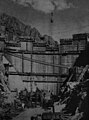
Status of work 1960


literature
- Isam S. Sahawneh: Rehabilitation Works of the Sefid Rud Dam. In: VSL News. Vol. 2, No. 2, 1991, p. 13, digital version (PDF; 427 kB) .
See also
- List of the largest dams on earth
- List of the largest reservoirs on earth
- List of the largest hydroelectric plants in the world
- List of power plants in Iran
- List of dams in the world (Iran)
Web links
- Iran Soil & Water Engineering Site Iran Dams: Amir-Kabir (Karaj) ( Memento from October 15, 2007 in the Internet Archive )