Sefid Rud dam
| Sefid Rud dam | |||||||
|---|---|---|---|---|---|---|---|
| Reservoir | |||||||
|
|||||||
|
|
|||||||
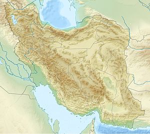
| Coordinates | 36 ° 45 ′ 31 ″ N , 49 ° 23 ′ 16 ″ E | ||||||
| Data on the structure | |||||||
| Construction time: | 1956-1952 | ||||||
| Height of the barrier structure : | 105 m | ||||||
| Crown length: | 425 m | ||||||
| Crown width: | 8 m | ||||||
| Power plant output: | 87 MW | ||||||
| Data on the reservoir | |||||||
| Storage space | 1.67 billion m³ | ||||||
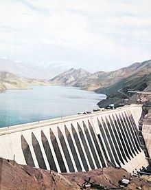
The Sefid Rud Dam also known as the Shahbanu Farah Dam ( Persian سد شهبانو فرح) or Manchil Dam ( Persian سد منجیل; سد سفیدرود) is a large dam at the confluence of the Schahrud and Qezel Uzan rivers.
The dam, started in 1956 and completed by a French consortium in 1962, is located at the entrance to the Sefid Rud gorge through the Elburs Mountains . It is 105 meters high and 425 meters long and holds a maximum of 1.67 billion cubic meters of water.
With the dam, the water supply in the Gilan plain was regulated, which led to an expansion of the arable land by initially 60,000 (today 188,000) hectares. In winter the Sefi Rud carries large amounts of water, while in summer there is low water. Until the construction of the dam, the water ran off unused in winter, while in summer there was no water to irrigate the fields in Gilan. By regulating the river, the rice cultivation area could be increased by half.
There is a hydroelectric power station at the foot of the dam . The original capacity of 35 MW was expanded to 87 MW.
The construction costs of the dam, including the connecting canals, amounted to Rls 7,700 million (EUR 200 million).
See also
- List of the largest dams on earth
- List of the largest reservoirs on earth
- List of power plants in Iran
- List of dams in the world (Iran)
literature
- Hans Bobek : Iran. Problems of an underdeveloped country of ancient culture. 2nd Edition. Diesterweg, Frankfurt am Main et al. 1964.


