
Mörbitz
The Mörbitz is a between Waldkirchen / Erzgeb. and Augustusburg forest area in Saxony (Germany).
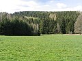
geography
The Mörbitz and the Heidelberg (506.5 m) form the northern part of the Börnicher ridge . The subsoil of the Mörbitz consists of mica slate and is not very suitable for arable farming. The Mörbitz area is traversed by the deeply cut valleys of the Staupenbach and the Mörbitzbach, both of which flow into the Zschopau . The Urlstein and the Two Rocks south of the Heidelberg are to be mentioned as prominent landmarks.
history
Flora and fauna
Historical descriptions of the area mention beech , fir and maple as tree species . Today the forest consists mainly of spruce , but there are also smaller stands of pine , beech , hornbeam , oak , Douglas fir and larch . The original vegetation with precious hardwoods is mainly on the difficult to access steep slopes of the Zschopau . With the recent afforestation by private owners and forest conversion measures in the state forest, other tree species are also being planted. Red elder and buckthorn can be found among shrub species . On the western and southwestern edge (towards Waldkirchen) the Mörbitz dissolves into a loose field-forest structure. The Staupenbach forms the border between the forest on the Waldkirchen side, which is mainly privately or communally owned, and the state forest. At the Staupenbach there are sometimes very wet to boggy meadows that still have extensive stocks of forest cowslip and other meadow plants ( cuckoo carnation , meadow knotweed ), previously existing orchids and sundew stocks have apparently died out due to abandonment or intensive use (cattle pasture). Main game species in the moerbitz are deer - and wild , next come u. a. Fox and badger in front.
Economic use
On the Staupenbach, the water power was used by the Busch or Rachel mill ( ⊙ ), built in 1845 as a grinding and cutting mill with an attached bakery , first through an overshot water wheel and from 1942 through two turbines. The name Rachelmühle is derived from the expression Rachel for a deep valley. In 1867 Ernst Louis Klotz from Witzschdorf bought the mill and at the same time applied for a license, which he finally received after several correspondence. After the First World War , a production facility for wooden goods such as handcarts, sledges, ironing boards and wooden slippers was established. Production ceased in 1952 and the water turbines continued to generate electricity until 1956. It was connected to the public power grid. In 1980 the building was converted into a residential building.
To ensure the quality of the yarns produced by the "Saxon Nähfadenfabrik" in Witzschdorf increase was in 1860 at distemper creek near the Zschopau a cotton bleaching and -färberei ( ⊙ built). The Staupenbach supplied the clear water and drive energy required for production. With the construction of the Hahn workers' settlement in 1872, a fire water pond ( ⊙ ) was created because the fire brigade could not reach the settlement quickly enough in the event of a fire . For this purpose, the stream was led into an artificial run about 300 meters upstream. The pond was later used as a bathing pond and today, along with some others, is used for fishing.
The Staupenbach has also been used since 1973 for the process water supply of the "VEB Texturseidenwerk Flöha, Witzschdorf section". For this purpose, a reservoir was built about 200 meters above the Buschmühle and a supply line to the central water tank in Witzschdorf was built. Some of them were made into drinking water here. With the end of production and the later liquidation of the plants in 1992, the supply is given up.
photos
In the Staupenbachtal

Staupenbachtal

The Urlstein seen from the south

Dyeing and bleaching works as well as the “Hahn” workers' estate (on the right in the picture) in Mörbitz


literature
- The middle Zschopau area (= values of our homeland . Volume 28). 1st edition. Akademie Verlag, Berlin 1977, p. 134.
Web links
Coordinates: 50 ° 47 ′ 0 ″ N , 13 ° 6 ′ 0 ″ E