
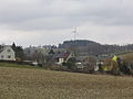
Waldkirchen / Erzgeb.
|
Waldkirchen / Erzgeb.
Community Grünhainichen
|
|
|---|---|
 |
|
| Height : | 453 m above sea level NN |
| Area : | 8.96 km² |
| Residents : | 1120 (May 9, 2011) |
| Population density : | 125 inhabitants / km² |
| Incorporation : | March 1, 2009 |
| Postal code : | 09437 |
| Primaries : | 037294, 03725 |
Waldkirchen / Erzgeb. has been a part of the community Grünhainichen in the Erzgebirgskreis in Saxony (Germany) since March 1st, 2009 . The municipality of Grünhainichen also belongs to the Wildenstein administrative association, like Waldkirchen before , while the district of Zschopenthal belongs to Waldkirchen .
history
Waldkirchen im Erzgebirge is mentioned for the first time in the feudal book of Friedrich III, the Strict , Margrave of Meißen and Landgrave of Thuringia , from the winter of 1349/1350 together with the neighboring villages of Börnichen / Erzgeb. (Burnichin) and Grünhainichen (Heinichin) mentioned in a document as "Waltkirchen". The actual establishment of the place probably took place earlier in the course of the settlement of the Ore Mountains, about the origin of the first settlers can only be speculated. As can still be seen today from the layout of the village and the field, Waldkirchen was created as a typical Waldhufendorf village. The farms are to the right and left of the village stream, the original hooves extend north to the Staupenbachtal ( Mörbitzgrund ) and south to the Krumhermersdorfer Bach.
Waldkirchen developed from a church at the end of the village in the direction of Grünhainichen , from which the name of the place is derived, along a nameless side valley of the Zschopau. With the Reformation in 1539, Waldkirchen became an independent parish. The place was the official village of the Office Augustusburg (formerly Schellenberg). The Zschopenthal settlement was built on the Zschopau itself (first mentioned in church records in 1663), and a blue paint factory was built there in 1687 . This was in operation until 1848 and was then converted into a weaving and twisting mill. On June 1, 1850, the community of Zschopenthal and the estate district Blaufarbenwerk Zschopenthal were incorporated. In 1865 the covered wooden bridge over the Zschopau was replaced by a stone bridge. In 1866, when the Zschopautalbahn was opened, it was connected to the rail network. The volunteer fire brigade was founded in 1874. A new church was built in 1901 and, from 1936 onwards, again bears the name “St. Georg ".
On November 27, 1918, Waldkirchen was renamed Waldkirchen-Zschopenthal . From the mid-1920s, the place developed into a stronghold of the NSDAP in the Ore Mountains. From 1936 onwards, a community of settlers built twelve homes.
The place name Waldkirchen-Zschopenthal was on October 1, 1939 by order of the Reichsstatthalters Martin Mutschmann in Waldkirchen / Erzgeb. changed. In an air raid that originally targeted Chemnitz , 25 houses were totally destroyed and another 42 were badly damaged in the night of February 14-15, 1945. Six people died in this attack.
Waldkirchen was always in close contact with the neighboring villages of Grünhainichen , Borstendorf and Börnichen . Waldkirchen was originally the center of a parish to which Krumhermersdorf also belonged for a time during the Thirty Years' War . The parish was only dissolved at the beginning of the 20th century, when the former subsidiary communities became independent. Today the pastor of Waldkirchen also looks after the Börnichen and Grünhainichen parishes. Since the 1990s, the places mentioned have been combined in the Wildenstein Administrative Association (after a hill between Börnichen, Waldkirchen and Grünhainichen).
Merger with Grünhainichen
On March 1, 2009, the previously independent communities Grünhainichen and Waldkirchen merged to form the new community Grünhainichen.
Population development
The following population figures refer to December 31 of the previous year with the territory January 2007:
1982 to 1988
- 1982-1373
- 1983-1360
- 1984-1335
- 1985-1305
- 1986-1286
- 1987-1266
- 1988-1204
1989 to 1995
- 1989-1207
- 1990-1191
- 1991-1170
- 1992 - 1171
- 1993-1154
- 1994 - 1161
- 1995 - 1197
1996 to 2002
- 1996 - 1183
- 1997-1201
- 1998-1203
- 1999 - 1221
- 2000-1220
- 2001 - 1214
- 2002 - 1214
2003 to 2007
- 2003 - 1213
- 2004 - 1201
- 2005 - 1200
- 2006 - 1185
- 2007 - 1173
- Source: State Statistical Office of the Free State of Saxony
coat of arms
The coat of arms of the former municipality shows the eponymous church "in the forest". In the lower part of the coat of arms reference is made to the tradition of blue paintwork with the tools of the blue paintworkers on a blue background.
Infrastructure
traffic
_(1).JPG)
Waldkirchen has a train station on the Annaberg-Buchholz and Bf-Flöha railway line (Zschopautalbahn), which is served by the DB subsidiary Erzgebirgsbahn . The federal highway 174 can be reached via a feeder in Gornau .
Economy and industry
While agriculture initially dominated the town as the main line of business, the manufacture of wooden toys and utensils began to emerge in the 17th century , which was carried out especially on behalf of Grünhainichner publishing houses.
In Zschopenthal you can still visit the former blue paint factory in Zschopenthal next to the mill .
Attractions
The original church, from which the place name is derived, today only serves as a burial chapel, of the originally rich medieval furnishings only remains. The Protestant church in the middle village above the district of Stein, which defines the townscape today, was built in 1900/1901 by a Chemnitz master builder in the New Renaissance style. Below the church is the school, built in 1905, which today houses a primary school after various modifications after the Second World War.
The Wichernhaus (also known as “The Stift” for short in Waldkirchen parlance) of the Inner Mission is located close to the corridor border to Börnichen . It was founded in 1852 and goes back to the judicial officer Friedrich August Förster in Augustusburg , who was in correspondence with Johann Hinrich Wichern in Hamburg . For financial reasons, the house had to be closed in 1865; it was not reopened until 1881 under the direction of the Inner Mission. Today there is a dormitory and a workshop for mentally handicapped people in the buildings, which are managed by the Diakonie , Stadtmission Chemnitz eV. Station 90 of the Royal Saxon Triangulation is located on Ullmanns Kuppe on the road towards Augustusburg .
Personalities
- Adolf Drechsler (1815–1888), astronomer, meteorologist and philosopher
- Günther Trommer (1918–1990), politician (SPD), member of the North Rhine-Westphalian state parliament
- Frank Schubert (* 1949), enduro athlete
- Rolf Hübler (1956–2013), enduro athlete
photos

St. George Church
View from Mitteldorf to the Wichernhaus
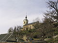
View of the church from the Stein district

Old church, today's cemetery chapel
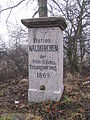
Triangulation station


literature
- Waldkirchen near Zschopau . In: August Schumann : Complete State, Post and Newspaper Lexicon of Saxony. 12th volume. Schumann, Zwickau 1825, p. 399 f.
- The parish Waldkirchen In: New Saxon Church Gallery, Ephorie Marienberg. Strauch Verlag, Leipzig, Sp. 693–726 ( digitized version )
- The middle Zschopau area (= values of our homeland . Volume 28). 1st edition. Akademie Verlag, Berlin 1977, pp. 134-137.
- District Office Middle Erzgebirgskreis, Ed .: On the history of the cities and municipalities in the Middle Erzgebirgskreis , a time table (parts 1–3)
- Richard Steche : Waldkirchen. In: Descriptive representation of the older architectural and art monuments of the Kingdom of Saxony. 6th booklet: Amtshauptmannschaft Flöha . CC Meinhold, Dresden 1886, p. 86.
- Gisela Lorenz: Family book of the parish Waldkirchen with Grünhainichen and Börnichen (district Zschopau) 1548 to 1715. Leipzig: AMF 1999 (= Central German local family books of the AMF 4)
Web links
Individual evidence
- ↑ Small-scale municipality sheet for Grünhainichen. (PDF; 0.23 MB) State Statistical Office of the Free State of Saxony , September 2014, accessed on January 29, 2015 .
- ↑ a b Das Sachsenbuch, Kommunal-Verlag Sachsen KG, Dresden, 1943
- ↑ StBA: Area changes from January 2nd to December 31st, 2009