Iranian highlands
The Iranian highlands , also Persian plateau ( Persian فلات ایران Falāt-e Īrān ) and similarly called, is a mountainous region in Asia , between the Mesopotamia in the west and the Hindu Kush region in the east.
Delimitation and name
The northern border of the highlands lies in Central Asia , in the south the Persian Gulf , the Strait of Hormuz and the Gulf of Oman border the area. It includes not only Iranian territory, but also parts of Afghanistan , Azerbaijan , Pakistan and Turkmenistan . The name is based on the early Iranian- speaking peoples who call themselves " Aryans " , that is to say that branch of the Indo-Europeans , which began in the 2nd millennium BC. BC populated and cultivated the region. The term is often equated with the Iranian-influenced cultural region, referred to by the Encyclopaedia Iranica as Iranian Cultural Continent and by some Iranists as "Greater Iran", which largely coincides with the Iranian highlands and, beyond these, in particular to neighboring regions in the Caucasus , encroached in Central Asia and Anatolia .
Landscape and geology
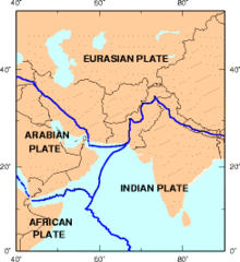
The highlands are formed from a tectonic plate ( Iranian plate ) as part of the Eurasian plate , wedged between the Arab and Indian plates . It belongs to the Alpid mountain belt , which merges in the north in the Kurdistan region into the Anatolian highlands and the Caucasus region and continues in the east in the Hindu Kush region, the Pamirs and the Himalayas . The actual fold mountains , which border the highlands as marginal mountains , are the Elbursgebirge ( Kuh-e Alborz ) in the north, against the Caspian Sea and Kopet Dag and Aladağlar against the Karakum , in the west and southwest the Zagros Mountains against the Euphrates lowlands and the Persian Gulf. In the southeast, the highlands pass over the mountain ranges Kuh-e Jebal Barez , Kuh-e Birag , Kuh-e Taftan and Kuh-i Sultan group and the Jaz Murian valley into the mountainous region of Balochistan . The highlands themselves cannot be assigned to the Alpid orogeny, but rather to be seen in connection with the formations of the Urals and Hajar (Omanzug). Due to the active tectonics, the region is prone to earthquakes and shows recent volcanism.
The highlands are divided by the NW- SE trending tributaries of the Zagros, the Kuhrudkette (Kuh-e Rud), Kuh-e Davaran and Kuh-e Banan . The great deserts of the plateau (Lut / Dasht-e Lut, Dascht-e Kawir, Rigestan, Dascht-e Margoh, Jaz Murian, Hamum-i Mashkel) lie between the mountain ranges and the Kuhrud .
Web links
- Iran (Iranian Plateau) from Encyclopædia Britannica 1911
- Map of the Iranian Highlands , on peakbagger.com
Individual evidence
- ^ Robert H. Dyson: The archaeological evidence of the second millennium BC on the Persian plateau . ISBN 0-521-07098-8 ( openlibrary.org ).
- ↑ James Bell: A System of Geography, Popular and Scientific . Archibald Fullarton , 1832, p. 7, 284, 287, 288 ( limited preview in Google Book search).
- ↑ Article Iranian highlands , in: Britannica .
- ^ So Richard Nelson Frye : Greater Iran. A 20th-century odyssey . Second edition. Mazda Publications, Costa Mesa / CA 2011, ISBN 1-56859-177-2 , p. XI.
- ↑ O. Thiele: On the age of metamorphosis in central Iran . In: Communications from the Geological Society in Vienna . tape 58 . Vienna 1965, p. 87–101 ( University of Innsbruck [PDF; accessed on May 16, 2018]).
- ↑ Nasrollah Mansur: The Iranian high plateau and the earthquake problem . In: Nasser Kanani, A. Ahgary (eds.): Gahname. Trade journal of the Association of Iranian Natural Scientists and Engineers (VINI) in the Federal Republic of Germany V. No. 9 ( PDF , vini.de [accessed on January 1, 2009]).


