Strait of Hormuz
| Strait of Hormuz | ||
|---|---|---|
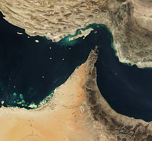
| Strait of Hormuz satellite image | ||
| Connects waters | Persian Gulf | |
| with water | Gulf of Oman , Arabian Sea | |
| Separates land mass | Arabian Peninsula | |
| of land mass | Asia | |
| Data | ||
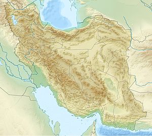
| Geographical location | 26 ° 34 ′ N , 56 ° 15 ′ E | |
|
|
||
| Smallest width | 55 km | |
| Coastal towns | Bandar Abbas | |
| Islands | Hormuz | |
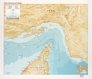
| Strait of Hormuz map | ||
The Strait of Hormuz ( Persian تنگه هرمز Tange-ye Hormoz , Arabic مضيق هرمز, DMG Maḍīq Hurmuz ) is a strait 55 kilometers (30 nautical miles ) wide at the narrowest point between the opposite mainland coasts , which connects the Persian Gulf in the west with the Gulf of Oman , the Arabian Sea and the Indian Ocean in the east. The narrowest point between the islands of Larak (Iran) and Great Quoin, Salāma (Oman) is only about 38 kilometers (20 nautical miles).
geography
It lies between an indentation on the coast of Iran and the Musandam peninsula, which protrudes from Arabia and belongs to Oman as an exclave . The Strait of Hormuz has been an important shipping route since ancient times . All shipping traffic to and from the oil ports of Kuwait , Qatar , Bahrain , Iraq , the United Arab Emirates and Iran runs through them , as well as most of the Saudi Arabian traffic. Because blocking the road would block supplies from significant parts of the Middle East's oil regions, it is of global strategic importance (approximately one-fifth of global oil supplies).
history
Until the 16th century, the Strait of Hormuz was the main waterway on the trade route from Europe to India . The important port city of Hormuz (probably on the mainland north of the road), which probably gave the name to the Strait of Hormuz, the island of Hormuz and the former Kingdom of Hormuz, was located on it.
There were also trade contacts with the Empire of China . The Strait of Hormuz and the areas to the west were a destination for the treasure fleet of Chinese Admiral Zheng He in the early 15th century. By traveling Vasco da Gama the trade monopoly of the Arabs was broken, because the sea route around the Cape of Good Hope was until the opening of the Suez Canal the Hauptschifffahrtsweg.
Since the beginning of the 19th century, Great Britain had cultivated a close relationship with the sheikdoms on the Gulf Coast, in particular with the Sultan of Oman, as he controlled access to the Strait of Hormuz, which was of great importance for the British trade routes to India (cf. . also contract man ).
Since 1971 there has been a conflict between Iran and the United Arab Emirates over Abu Musa and the Tunb Islands , which are of particular strategic importance with regard to the control of the Strait of Hormuz.
Economical meaning
The road is the main bottleneck for oil exports to Asia (China, India, Japan), Western Europe and the USA. Tankers with 16.5–17 million barrels of oil (2004; 25 percent of world oil consumption, 2013; 40 percent of world oil consumption) valued at 1 billion US dollars (at an oil price of around 60 dollars / barrel) pass through them daily. For this purpose, there are two “virtual boxes”, each 3 kilometers wide and 35 kilometers long, for incoming and outgoing traffic ( traffic separation area ) as international shipping routes .
In connection with the threatened US attack on Iran because of its nuclear program in 2006/2007 , the US government feared that the road would be closed by means of cruise missiles . For this reason, in early 2007 aircraft carriers and mine clearance attendants were positioned near the strait.
In the context of the dispute over the Iranian nuclear program , the First Vice President of Iran, Mohammad Reza Rahimi , threatened to close the Strait of Hormuz if an oil embargo was imposed on Iran at the end of December 2011 .
Legal situation

In order to cross the Strait of Hormuz, ships must cross the territorial waters of Oman and Iran. The passage is to be regulated according to the UN Convention on the Law of the Sea . According to this agreement, ships have the right of transit passage . Warships are treated like merchant ships and are allowed to travel quickly through the road without prior notice. The Agreement on the Law of the Sea was signed by Iran, but not ratified , so it has not yet become valid for the Strait of Hormuz. If Iran acceded to the agreement, it would only grant those states that have also acceded to the Convention on the Law of the Sea the more extensive rights. The US has not yet acceded to this agreement.
Both states have signed the Geneva Convention on the Law of the Sea , but only the US has ratified it. According to these conventions, ships have the right of peaceful passage in the Strait of Hormuz. Stricter requirements apply to warships. Submarines are only allowed to drive through the street when they have surfaced and flagged. All warships must obtain permission from Iran before they can pass through. Iran continues to claim the right to permit the passage of military ships.
The USA continues to allow its warships to pass the Strait of Hormuz unannounced, invoking customary international law, which was codified under the United Nations Convention on the Law of the Sea. However, the US never acceded to the Convention on the Law of the Sea.
Web links
Individual evidence
- ^ The Strait of Hormuz is the world's most important oil transit chokepoint - Today in Energy - US Energy Information Administration (EIA). Retrieved July 30, 2019 .
- ^ Energy Statistics from the US Government
- ↑ US Navy Positioning to Protect Strait of Hormuz, Tuesday, Feb. 20, 2007 ( Memento of February 23, 2007 in the Internet Archive )
- ↑ Islamic Republic News Agency (IRNA) : 1st VP: No single drop of oil will pass through Hormuz Strait if Iran oil is banned from December 27, 2011. Accessed January 16, 2012.
- ^ US Department of State : Limits in the Sea, National Claims to Maritime Restrictions. (PDF; 7.8 MB) May 25, 2000, archived from the original on January 13, 2008 ; Retrieved March 14, 2012 .


