Bandar Abbas
| Bandar Abbas | ||
|---|---|---|
|
|
||
| Basic data | ||
| Country: |
|
|
| Province : | Hormozgan | |
| Coordinates : | 27 ° 11 ′ N , 56 ° 18 ′ E | |
| Height : | 7 m | |
| Residents : | 526,648 (2016 census) | |
| Area code : | 0761 | |
| Time zone : | UTC +3: 30 | |
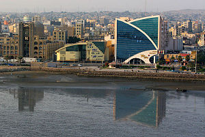
Bandar Abbas ( Persian بندر عباس, DMG Bandar [-e] Abbās , 'Port of Abbas') is the capital of the Hormozgan Province in southern Iran on the Persian Gulf and one of the headquarters of the Iranian Navy .
The city is named after the Shah Abbas I. It has the largest port in Iran and has long been known under the name Gamron. In 2016 it had 526,648 inhabitants. In front of the city is the island of Hormuz .
From the international airport you can fly to the nearby Dubai and Sharjah in the United Arab Emirates in addition to domestic destinations . It is 1331 km by land to the capital Tehran .
history
Emergence
The village, which today bears the name Bandar Abbas, was already an important port city in the time of Darius I. In the course of its long history, the city has changed its name several times. After the conquest of Persia by Alexander , the city was named Hormirzad.
In 1507 the Portuguese occupied the city of Šahrū and gave it the name Comorão, which became Gamron in English . In 1615, the Safavid Shah Abbas I, with the support of a squadron of the East India Company from Bandar-e Jask , succeeded in wresting the island of Hormoz and the port built on it from Portuguese rule. In 1623 he moved the port to the mainland and gave the city there its current name, Bandar Abbas. Sir Thomas Herbert gave in his travels in Persia (1627-1629) the international name of the place with Gamrou, Gomrow or Cummeroon.
Although the city owned the main Safavid port, it grew slowly. Around 1670 the number of houses was estimated at 1400 to 1500. This fact is mainly due to the poor supply of fresh water and food, as no agricultural cultivation was possible in the region due to the great heat and drought in summer.
Nevertheless, the city developed into a central trading point. Trade with Great Britain , India and the Netherlands was conducted through the city's port. The import of spices from the Netherlands made them influential trading partners.
Decay
In the course of the uprising and invasion of the Afghans in 1722 and the end of the Safavid dynasty, five years later a few thousand Baluchi attacked Bandar Abbas and looted large parts of the trading facilities. In 1736 the Afsharid dynasty was established, the first of which, Nadir Shah Bandar Abbas, disregarded and instead built Bushehr to become the most important port city, which was closer to the important cities of Shiraz and Isfahan . Even the British and Dutch factories and branches left the city by 1762.
Bandar Abbas now fell into the hands of the Omani sultans, who allowed the British East India Company to enter the city. There were multiple Persian raids on Bandar Abbas and the city repeatedly proved to be a burden on Oman. In 1868 the Qajars took control of Bandar Abbas. The city was ravaged by cholera during this time , but maritime trade developed again via the port. The main trading partners were again India and Great Britain, the British consulate reopened in 1900.
Resurgence
In the 20th century, the economy initially recovered only slowly. Under Reza Shah Pahlavi , a spinning mill and a fish processing factory were built in Bandar Abbas. The population continued to grow slowly. Estimates assume 20,000 inhabitants in 1928, 15,000 or 11,000 in 1937 and 17,710 in 1956. The majority of the city's residents were Shiites .
In 1964 it was decided to build a new port 8 km southwest of the city center, which was opened in 1967. The port quickly became an important transshipment point for ore from the region. As early as 1973, 300,000 gross register tons were loaded. Also in 1973, Bandar Abbas became a headquarters of the Iranian Navy and was connected to the country's motorway network. In 1966 a new television building was built in the style of local architecture, which later received an architecture award from the Aga Khan Foundation . Farah Pahlavi's office took over the planning and coordination .
With the economic boom and the new political importance, the population also rose rapidly. In 1966 around 34,000 people lived in Bandar Abbas, 10 years later there were already almost 90,000, only the region around the state capital Tehran had even higher growth rates.
In the 1990s, 75% of imports from the Persian Gulf passed through the port in Bandar Abbas.
climate
Bandar Abbas is a popular winter travel destination for Iranians, as the temperatures in winter are a pleasant 25 to 28 ° C during the day, while in summer they can easily rise to 45 ° C. Then there is an unbearable sultriness.
traffic
The port of Bandar Abbas is one of the most important overseas ports in Iran.
Bandar Abbas is the southern terminus of the north-south railroad from Mashhad .
To the east of the city is the Bandar Abbas International Airport . From there there are direct connections to Tehran and Dubai .
See also
Web links
- Cities of Iran. Bandar Abbas. In: IranChamber.com. (English).
Individual evidence
- ↑ Iran. Cities. In: CityPopulation.de. September 8, 2019, accessed February 5, 2020 .
- ↑ Emily Ruete : The Father's Journey. Memoirs of an Arab Princess. In: digital.staatsbibliothek-berlin.de. Volume 2, 1886, pp. 121–122 , accessed on August 30, 2019 (digitized version from the Berlin State Library).


