Gulf of Oman
| Gulf of Oman | |
|---|---|
|
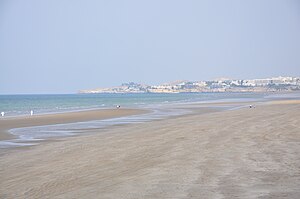
Beach near Muscat |
|
| Waters | Arabian Sea |
| Land mass | Arabian Peninsula , Asia |
| Geographical location | 24 ° 43 ′ N , 58 ° 20 ′ E |
| width | 405.5 km |
| depth | approx. 450 km |
| surface | 181,000 km² |
| Greatest water depth | 3694 m |
| Islands | Jazīrat Lima , Sawadi Islands , Dimaniyat Islands , Al Fahal , Snoopy Island |
| Tributaries | That |
|
Coast at Tschahbahar |
|
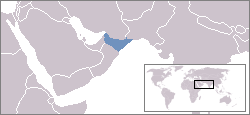
The Gulf of Oman ( Arabic خليج عُمان Chalīdsch Omān , DMG Ḫalīǧ ʿUmān ; oftenin Persian tooدریای ایران Daryā-e Īrān , "Iranian Sea", orدریای فارس Daryā-e Fārs , "Persian Sea") is the northwest arm of the Arabian Sea , which is connected to the Persian Gulf by the Strait of Hormuz .
Demarcation
![]() Map with all coordinates: OSM | WikiMap
Map with all coordinates: OSM | WikiMap
The International Hydrographic Organization (IHO) names the Gulf of Oman's borders:
- In the northwest (against the Persian Gulf ): a line between Ras Limah ( 25 ° 56 '44 " N , 56 ° 27' 21" O ) in the east of the Musandam -Halbinsel and Ras al cow ( 25 ° 47 '52 " N , 57 ° 17 ′ 52 ″ E ) on the coast of Iran
- In the southeast (towards the Arabian Sea ): a line between Ras al-Hadd ( 22 ° 31 ′ 57 ″ N , 59 ° 47 ′ 59 ″ E ) and Jiwani ( 25 ° 2 ′ 13 ″ N , 61 ° 44 ′ 24 ″ O ) on the southwest coast of Pakistan
According to this demarcation , the small island of Jazīrat Lima off Cape Ras Limah falls just under the Gulf of Oman. Other islands in the Gulf of Oman are Sawadi Islands , Ad Dimaniyat Islands and Al Fahal , all belonging to Oman.
According to the CIA demarcation, the Strait of Hormuz, which according to IHO belongs to the Persian Gulf, begins on the Omani (western) side 40 kilometers further south in comparison, namely instead of Ras Limah at Ras Diba ( 25 ° 35 ′ 47 ″ N , 56 ° 21 ′ 15 ″ E ).
John Gordon Lorimer (1908) established the demarcation between the Gulf of Oman and the Persian Gulf on the island of Jazīrat Musandam . The northeast corner of the island of Ras Musandam ( 26 ° 23 '11 " N , 56 ° 31' 41" O ), or 49 kilometers north of Ras Limah.
geography
The bay is about 450 km deep and 330 km wide. The maximum water depth is 3694 m. The coordinates that define the border line to the Arabian Sea according to IHO are 340.64 km apart. As an access route to the Persian Gulf, the Gulf of Oman is of great strategic importance, as the Gulf states are important oil production areas for the global economy. The Gulf of Oman is bordered by Iran and Pakistan in the north, the United Arab Emirates in the west and Oman in the south . South of Cape Ras al-Hadd on the east coast of Oman and east of Cape Ràs Jiyùnigeht on the south coast of Pakistan, it merges into the Arabian Sea .
Important ports on the coast of the Gulf of Oman are Muscat in Oman and Tschahbahar in Iran. According to this delimitation, Gwadar in Pakistan is already outside of the Gulf of Oman on the Arabian Sea. Iran intends to develop Bandar-e Jask , where it already has a naval base, into a major oil export port.
Web links
Gulf of Oman . In: Ehsan Yarshater (Ed.): Encyclopædia Iranica (English, including references)
Individual evidence
- ↑ International Hydrographic Organization: Limits of Oceans and Seas, 3rd edition, 1953 , p. 20
- ↑ Central Intelligence Agency: Strait of Hormuz and Vicinity (map from 1987)
- ↑ John Gordon Lorimer: Gazetteer of the Persian Gulf. Vol. II. Geographical and Statistical. Musandam, p. 1284
- ↑ Jask to Dubai (Dubayy) and Jazireh-ye Qeshm (Marine Chart: SA_2888_0)
- ↑ a b Article Gulf of Oman in the Great Soviet Encyclopedia (BSE) , 3rd edition 1969–1978 (Russian)


