
Musandam
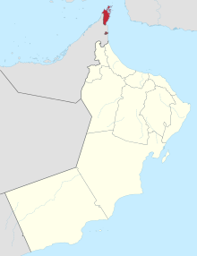


Musandam ( Arabic مسندم, DMG Musandam ) is a governorate (Arabic muḥāfaẓa ) in the north of the Sultanate of Oman with an area of 1,800 km² and 28,378 inhabitants (census December 7, 2003). The peninsula and offshore islands are located on the southern, Arabian side of the Strait of Hormuz . Musandam is therefore of great geopolitical and strategic value.
description
Musandam is an exclave , an outsourced part and not spatially connected to the national territory. In the northern area of Musandam, the only Iranian language on the Arabian Peninsula , the Kumzari , is spoken. Between Musandam and Oman there is a distance of around 100 kilometers through the United Arab Emirates . The Madha exclave also belongs administratively to Wilaya Musandam .
The main town of Musandam is al-Chasab , which has grown rapidly in recent years. In addition to its importance as a military base , fishing and the handling of goods (especially for Iranian smugglers' boats) are important. A restricted military area until 2005, the tourist infrastructure is also increasingly being expanded. There is great potential here due to the uniqueness of the landscape in Musandam, which is also known as “Norway of Arabia” because of its fjords .
The governorate also includes several islands close to the coast, including the very small Telegraph Island , which is known for its history .
geology
The coast is the result of the movement of the earth's crust . The Arabian Plate is slowly pushing under the Eurasian Plate , causing Musandam to sink and the nearby Iranian mountains to be prone to earthquakes.
Administrative structure
The Musandam Governorate is divided into four units ( wilayat ):
- al-Khasab (capital of the governorate)
- Bucha
- Dibba al-Baya
- Madha , itself an exclave that is surrounded by the territory of the United Arab Emirates , halfway between Musandam and the Omani region of al-Batina .
The head of administration is a so-called muhafiz . The current Muhafiz is Chalifa bin Murdas bin Ahmad al-Busaʿidi.
Geographical location
| Strait of Hormuz | Strait of Hormuz | Strait of Hormuz |
| Persian Gulf |
.svg)
|
Gulf of Oman |
| United Arab Emirates (Emirate of Ra's al-Khaimah ) | United Arab Emirates (Emirate of Fujairah ) | Gulf of Oman |
Web links
- Literature about Musandam in the catalog of the German National Library
- Musandam Governorate
Coordinates: 26 ° 0 ' N , 56 ° 18' E