
Fujairah (emirate)
|
الفجيرة al-Fuǧaira
|
|||
|---|---|---|---|
  |
|||
| Symbols | |||
|
|||
| Basic data | |||
| Country | United Arab Emirates | ||
| Capital | Fujairah | ||
| surface | 1165 km² | ||
| Residents | 213,712 (2015) | ||
| density | 183 inhabitants per km² | ||
| ISO 3166-2 | AE-FU | ||
| politics | |||
| emir | Hamad ibn Muhammad ash-Sharqi | ||
 |
|||


Coordinates: 25 ° 12 ' N , 56 ° 18' E
Fujairah , also known as Fujairah (English) ( Arabic إمارة الفجيرة, DMG Imārat al-Fuǧaira ), is one of the seven emirates that make up the United Arab Emirates (UAE). The population is around 214,000 (2015 estimate). The emirate is named after the port city of Fujairah , which is also its capital.
structure
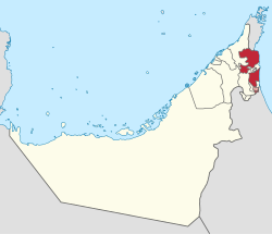
The emirate consists of two similarly sized parts of the country, which make up the majority of the total of 1165 km². Both parts of the country lie east of the Hajar Mountains on the east coast of the United Arab Emirates on the Gulf of Oman . The emirate has two cities, the capital Fujairah in the southern part of the country and the city of Dibba in the northern part.
In addition, there is an area administered jointly with the Emirate of Sharjah and the small exclave Ohala (اوحلة) belonging to Oman. On the northern border of the southern part of Fujairah is the Oman-owned Madha exclave . Fujairah and the Gulf of Oman also enclose the Khor Fakkan and Kalba exclaves belonging to Sharjah , which were still fought over in the first half of the 20th century.
The administrative division into the two municipalities of Fujairah and Dibba, which in addition to the cities, also includes around 34 villages, is not identical. The municipality of Fujairah not only includes the southern part of the country with the emirate capital and the exclave Ohala, but also the southwest and west of the northern part of the country. The municipality of Dibba also includes an uninhabited mountain area of around 242 km², where the Wadi-Wuraya reserve is located.
history
In 1902, Fujairah, then only a few houses, split off from the Emirate of Sharjah . On December 2, 1971, Great Britain released the former Trucial States , which also included Fujairah, into independence. Under the leadership of Abu Dhabi , the United Arab Emirates were founded from the former Trucial States Abu Dhabi, Dubai , Sharjah , Ajman , Umm al-Qaiwain , and Fujairah. Ra's al-Khaimah joined in 1972 as the seventh emirate.
Ruler
The Arab tribe asch-Sharqi and the emir are the rulers of the Emirate of Fujairah on the Gulf of Oman .
- 1903–1938 Hamad I.
- 1952-1975 Muhammad
- 1975 - Hamad II.
flag
When Hamad II came to power in 1975, he abolished the previous completely red flag and took over the federal flag of the United Arab Emirates with its three additional horizontal stripes green, white and black.
economy
Fujairah is economically largely dependent on Abu Dhabi . The emirate does not have its own oil wells, but it has larger cultivation areas for vegetables, date palms and other foods. The port economy and tourism are increasingly important sources of income. Fishing also plays a role.
Postage stamps
With the country names Fujeira and al-Fudschaira mostly large-format postage stamps with different motifs are sold, which are not primarily produced for postal use in the country, but as artificial collector's items and thus serve as an additional source of income for the country.
literature
- Fred Scholz (ed.): The small Gulf states . Klett-Perthes, Gotha and Stuttgart 1999
Web links
- Government Fudschairas (Engl.)
- Statistical Yearbook for Fujairah (2018)
- Statistical Yearbook for Fujairah (1997-2017)
Individual evidence
- ↑ Abdulla Al Khaddeim: GIS Initiatives for The Strategic Development of The Emirate of Fujairah
- ^ Emirate of Fujairah: Statistical Map 2013
Abu Dhabi | Ajman | Dubai | Fujairah | Ras al-Khaimah | Sharjah | Umm al-Qaiwain