
Calf

Kalba ( Arabic كلباء, DMG Kalbāʾ , occasionally Chelbah or similar) is a coastal settlement in the east of the United Arab Emirates .
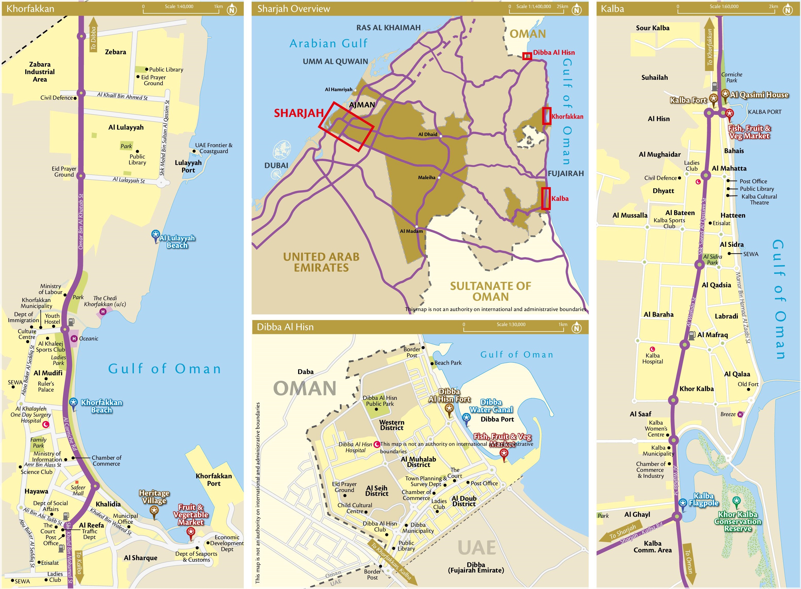
Kalba is an exclave of the Emirate of Sharjah on the Gulf of Oman and was an independent (eighth) emirate from 1903 to 1952. The emirate of Kalba also included the Khor Fakkan exclave , 30 kilometers north, and the Dibba al Hesn exclave , 60 kilometers north, both also on the coast of the Gulf of Oman. So that the former emirate Kalba corresponds to today's Eastern Region of the Emirate of Sharjah, with its three Municipalities (municipalities).
Exclave Kalba
The Kalba exclave covers about 100 km² and 35,000 inhabitants. On the land side, Kalba is surrounded by the Emirate of Fujairah in the north, an area administered jointly by Fujairah and Sharjah in the west, an exclave of Fujairah in the southwest and the Sultanate of Oman in the south. The only road to Sharjah, the E 102 Sharjah-Kalba-Road, leads through the Wadi al-Qur in the Hajar Mountains, part of the Emirate of Ra's al-Khaimah .
City structure
The districts of Kalba include, from north to south: Sour Kalba, Suhaila, Al Hisn, Bahais, Al Mughaidar, Al Mahatta. Dhyatt, Al Bateen, Al Mussalla, Hatteen, Al Sidra, Al Qadsia, Al Baraha, Labradi, Al Mafraq, Al Qalaa, Khor Kalba, Al Saaf, Al Ghayl
Emirate of Kalba

The fishing village of Kalba, which was founded 2,500 years ago, was occupied by the Portuguese from 1507 to 1623 and the Persian from 1737 to 1743, like the Khor Fakkan to the north. The Portuguese built a fort in Kalba and the Arabs built the Al-Hisn Fort on the remains. After the Persians were driven out, the entire region of Sharjah and Ra's al-Khaimah fell under the rule of Huwala at the end of the 18th century -Tribe belonging clans of the Qawasim or the dynasty of the al-Qasimi , which in turn was forced under the British Protectorate Treaty from 1820. After the Qasimi power had disintegrated into the Emirates of Sharjah and Ra's al-Khaimah in 1869 and the asch-Sharqi ruling in Fujairah had shaken off the suzerainty of the Qasimi, the Qasimi prince Majid ibn Sultan al-Qasimi (1871–1900) began in 1871. to create a power base in Kalba for the intra-dynastic struggles. Formally, however, Kalba initially continued to see himself as part of Sharjah, also under Majid's successor Hamad ibn Majid al-Qasimi (1900-1903). After further intra-dynastic disputes, however, Kalba (with Khor Fakkan) and Dibba fell away from Sharjah in 1903 .
From the mid-1920s to the early 1930s, the Qasimi in Kalba suffered from repeated attacks, especially from the Sharqiyyin from Fujairah. Any troop deployments from Sharjah were blocked by the fact that the land access to Sharjah, the Wadi al-Qur, was controlled by Ra's al-Khaimah. Under the local rulers Sayyid ibn Hamad al-Qasimi (1903-1937) and Hamad ibn Sayyid al-Qasimi (1937-1951), however, Kalba was recognized by the British on December 8, 1936 as an independent emirate of the contracting states . In return, the Emir of Kalba concluded oil concession agreements with the British Iraq Petroleum Company in 1937 and negotiations for the construction of a runway for the Royal Air Force began. After Hamad's death, Kalba fell to the Emir Saqr ibn Sultan al-Qasimi of Sharjah in May 1951 and was reintegrated into Sharjah in 1952.
Khor Kalba

In contrast to the port cities of Fujairah and Khor Fakkan, Kalba has so far hardly been developed economically or in terms of tourism, but it has a modern hospital and a football club (Al-Ittihad Kalba). The area north of the city of Kalba is still mainly used for agriculture. South of the city is the mangrove swamp Khor Kalba (Khawr Kalba), which is a bird sanctuary.
swell
- Detlef Müller-Mahn: United Arab Emirates - a federal state with a wealth gap . In: Fred Scholz (ed.): The small Gulf states - Perthes country profiles , pages 209ff. Klett-Perthes, Gotha and Stuttgart 1999
- Lothar Rathmann : History of the Arabs - From the beginnings to the present , Volume 3 (The Arab liberation movement in the fight against imperialist colonial rule, 1917–1945), page 243f. Akademie-Verlag, Berlin 1974
- Muḥammad Mursī ʻAbd Allaah: The United Arab Emirates - A Modern History , pp . 307-315 . Taylor & Francis, London 1978
- worldstatesmen.org: United Arab Emirates, Kalba
Web links
- planetware.com: Kalba, United Arab Emirates
- flaggenlexikon.de: Kalba
Individual evidence
- ^ Historical Summary of Events in the Persian Gulf Shaikhdoms and the Sultanate of Muscat and Oman, 1928-1953 , p. 143
- ↑ OnTheWorldMap: Kalba (map with designated districts)
Coordinates: 25 ° 2 ′ N , 56 ° 21 ′ E